METAR & TAF 7M7
7M7 does not publish a METAR.
Showing the nearest reporting station: KTKX (KENNETT MEML) · 11.1 NM away. Conditions at 7M7 may differ.
METAR · KTKX
Observed 04:55Z
KTKX 270455Z AUTO 20004KT 10SM CLR 29/29 A2989 RMK AO2
- Wind
- 200° @ 4 kt
- Visibility
- 10 SM
- Temp / Dew
- 29°C / 29°C
- Altimeter
- 29.89 inHg
- Clouds
- CLR
- Density alt
- 2,058 ft
- Ceiling
- Unlimited
- Rules
- VFR
Airport info & contacts
Manager on record, flight service, ARTCC, attendance schedule and pattern altitude — published by the FAA and refreshed every 28 days.
Location
- From city
- 2 NM E
- VFR sectional
- ST LOUIS
- ARTCC
- ZME · MEMPHIS
- NOTAM facility
- JBR (NOTAM-D)
Airport manager
- Name
- JEFF PUCKETT
- Phone
- 870-324-2358
- Address
- 194 W. COURT, PIGGOTT AR 72454
Flight service · Hours
- FSS JBR
- JONESBORO1-800-WX-BRIEF
- Attendance
- Unattended
Frequencies
Tap any row to copy the frequency to your clipboard.
Runways & pattern
Full pagePattern entry · RWY 18
LEFT TRAFFICRunway end performance
| End | TORA | TODA | ASDA | LDA | VGSI | Approach lights | Obstruction |
|---|---|---|---|---|---|---|---|
| 36 | — | — | — | — | — | — | 35', trees, 1330' from thr, 185' R of cntrln, slope 32 |
Declared distances in feet. TORA = takeoff run available, TODA = takeoff distance, ASDA = accelerate-stop, LDA = landing distance.
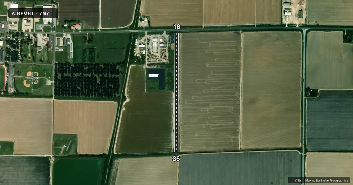
Airport sketch
Runways drawn to scale from FAA survey coordinates, rendered over satellite imagery. Not for navigation.
Approaches & charts
Services on the field
Fuel grades, oxygen, maintenance, ramp storage and lighting — as declared to the FAA by the airport operator.
Fuel & services
- Fuel
- Not available
- Oxygen (bottled)
- Not available
- Oxygen (bulk)
- Not available
- Airframe repair
- Not available
- Power plant repair
- Not available
- Other services
- AGRI,INSTR
Ramp & ground
- Transient storage
- Tie-down
- Landing fee
- No fee published
- Customs
- Not available
- Lighting schedule
- SEE RMK
- Beacon schedule
- SS-SR
- Beacon
- White / Green (civil land)(WG)
- Wind indicator
- Lighted
- Segmented circle
- Yes
Fuel & FBOs
Cheapest 100LL and Jet A on the field and nearby. Always confirm with the FBO before taxi.
Airport notes
Surface conditions, obstructions, local procedures, lighting outages and other notes published with each FAA cycle.
General notes
- SOUTH END OF RY 18/36 FLOODED AFTER HEAVY RAIN.
- FOR CD CTC MEMPHIS ARTCC AT 901-368-8453/8449.
Lighting notes
- ACTVT MIRL RY 18/36 - CTAF.
Approach & departure obstructions
- 18+20 FT HWY 51 FT FM RY END.
- 3615 FT DITCH 10 FT FM THLD.
- 18APCH SLOPE 27:1 BASED ON DSPLCD THLD.
- 36APCH SLOPE 44:1 BASED ON DSPLCD THLD.
Other notes
- MANAGERPIGGOTT ARPT COMMISSION CHAIRMAN.
VFR map & nearby airports
VFR sectional. Tap any ICAO chip to open that airport.
Key facts · 7M7
Answer card- ICAO
- 7M7
- Name
- PIGGOTT MUNI
- Location
- PIGGOTT, ARKANSAS
- Elevation
- 275 ft MSL
- Traffic pattern altitude
- 1,275 ft MSL (1,000 AGL)
- Control tower
- Non-towered (use CTAF)
- Total runways
- 1
- Longest runway
- 18/36 · 2,550 ft
- Published ILS approaches
- 0
- Published frequencies
- 1
- Magnetic variation
- 2°
- Current flight rules
- VFR
- Current wind
- 200° at 4 kt
- Favored runway now
- RWY 18
Piggott Muni is in Piggott, Arkansas. The field elevation is 275 ft MSL. It has one runway, 18/36 and the longest runway is 2,550 ft of asphalt. There is no control tower, so traffic is self-announce on CTAF 122.9.
No ILS approaches are published here. Pattern altitude is not published in the Chart Supplement. Use the standard 1,000 ft AGL for light piston operations unless the current Chart Supplement says otherwise. The runway lights on 18/36 are medium intensity and are activated from the CTAF. That is useful after sunset. Verify the current lighting setup before departure.
The published remarks matter here. The south end of runway 18/36 can flood after heavy rain. Runway 18 has a displaced-threshold obstacle note with a highway close to the departure end. Runway 36 also has a displaced-threshold note plus a ditch near the threshold. The approach slopes are tight on both ends. That makes a stabilized approach important, especially if you are new to the field. For clearance delivery, Memphis ARTCC is the published contact. Check the current Chart Supplement before you go if you need any updated operational detail.