METAR & TAF 37M
37M does not publish a METAR.
Showing the nearest reporting station: KTKX (KENNETT MEML) · 12.3 NM away. Conditions at 37M may differ.
METAR · KTKX
Observed 00:35Z
KTKX 250035Z AUTO 00000KT 10SM CLR 23/23 A3007 RMK AO2
- Wind
- 000° @ 0 kt
- Visibility
- 10 SM
- Temp / Dew
- 23°C / 23°C
- Altimeter
- 30.07 inHg
- Clouds
- CLR
- Density alt
- 1,082 ft
- Ceiling
- Unlimited
- Rules
- VFR
Airport info & contacts
Manager on record, flight service, ARTCC, attendance schedule and pattern altitude — published by the FAA and refreshed every 28 days.
Location
- From city
- 2 NM W
- VFR sectional
- ST LOUIS
- ARTCC
- ZME · MEMPHIS
- NOTAM facility
- STL (NOTAM-D)
Airport manager
- Name
- RONNIE BROWN
- Phone
- 573-737-2616
- Address
- PO BOX 219, HORNERSVILLE MO 63855
Flight service · Hours
- FSS STL
- SAINT LOUIS1-800-WX-BRIEF
- Attendance
- Unattended
Frequencies
Tap any row to copy the frequency to your clipboard.
Runways & pattern
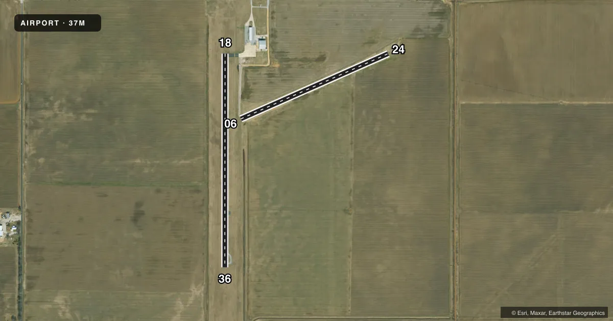
Full pagePattern entry · RWY 18
LEFT TRAFFICAirport sketch
Runways drawn to scale from FAA survey coordinates, rendered over satellite imagery. Not for navigation.
Approaches & charts
Services on the field
Fuel grades, oxygen, maintenance, ramp storage and lighting — as declared to the FAA by the airport operator.
Fuel & services
- Fuel
- Not available
- Other services
- AGRI
Ramp & ground
- Transient storage
- Tie-down
- Hangar
- Landing fee
- No fee published
- Customs
- Not available
- Wind indicator
- Yes
- Segmented circle
- No
Fuel & FBOs
Cheapest 100LL and Jet A on the field and nearby. Always confirm with the FBO before taxi.
Airport notes
Surface conditions, obstructions, local procedures, lighting outages and other notes published with each FAA cycle.
General notes
- CROP DUSTING OPERATIONS ON & INVOF ARPT.
- BE ALERT TO LRG PIVOT IRRIGATION SYS ON WEST SIDE OF RWY.
- NIGHT OPERATIONS NOT RECOMMENDED AT THIS AIRPORT.
- RY 06/24 MARKED WITH LARGE YELLOW CONES.
- FOR CD CTC MEMPHIS ARTCC AT 901-368-8453/8449.
Runway surface & condition
- 18/36DAYTIME OPNS ONLY.
- 18/36RY 18/36 WIDTH VARIANCE 47-50 FT.
Other notes
- ESTABD PRIOR OCT 1959.
VFR map & nearby airports
VFR sectional. Tap any ICAO chip to open that airport.
Key facts · 37M
Answer card- ICAO
- 37M
- Name
- HORNERSVILLE MEML
- Location
- HORNERSVILLE, MISSOURI
- Elevation
- 248 ft MSL
- Traffic pattern altitude
- 1,248 ft MSL (1,000 AGL)
- Control tower
- Non-towered (use CTAF)
- Total runways
- 2
- Longest runway
- 18/36 · 2,648 ft
- Published ILS approaches
- 0
- Published frequencies
- 1
- Magnetic variation
- 2°
- Current flight rules
- VFR
- Current wind
- 000° at 0 kt
- Favored runway now
- –
Hornersville Meml (37M) sits in Hornersville, Missouri. The field elevation is 248 ft MSL. It has two runways. The longest is 18/36 at 2,648 ft. Runway 06/24 is turf at 2,000 ft. There is no control tower. CTAF 122.9 is the published traffic frequency.
No ILS approaches are published here. Pattern altitude is not published, so use the standard 1,000 ft AGL pattern for light piston operations unless the current Chart Supplement says otherwise. The airport has a few operational notes that matter on a first visit. Runway 06/24 is marked with large yellow cones. Runway 18/36 is listed as daytime only. Night operations are not recommended at this airport. Crop dusting operations occur on and near the field. Large pivot irrigation systems are also reported on the west side of the runway.
There are no on-field FBOs listed. Plan on calling the airport operator or the field directly before arrival if you need current services. Clearance delivery is handled through Memphis ARTCC per the published remarks. This is a small non-towered field with limited runway length, so keep your arrival simple, stay alert for ag traffic and verify current notes in the FAA Chart Supplement before you go.