METAR & TAF 4M9
Current METAR
Observed 15:15Z
K4M9 271515Z AUTO 20006KT 10SM CLR 30/27 A2995 RMK A01
- Wind
- 200° @ 6 kt
- Visibility
- 10 SM
- Temp / Dew
- 30°C / 27°C
- Altimeter
- 29.95 inHg
- Clouds
- CLR
- Density alt
- 2,126 ft
- Ceiling
- Unlimited
- Rules
- VFR
Airport info & contacts
Manager on record, flight service, ARTCC, attendance schedule and pattern altitude — published by the FAA and refreshed every 28 days.
Location
- From city
- 3 NM W
- VFR sectional
- ST LOUIS
- ARTCC
- ZME · MEMPHIS
- NOTAM facility
- JBR (NOTAM-D)
Airport manager
- Name
- MATT WOOLARD
- Phone
- 870-323-0304
- Address
- P.O. BOX 451, CORNING AR 72422
Flight service · Hours
- FSS JBR
- JONESBORO1-800-WX-BRIEF
- Attendance
- MON-FRI · 0700-1900
- SAT · 0800-1200
- SUN · UNATTNDD
Frequencies
Tap any row to copy the frequency to your clipboard.
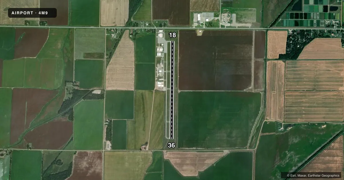
Runways & pattern
Full pagePattern entry · RWY 18
LEFT TRAFFICRunway end performance
| End | TORA | TODA | ASDA | LDA | VGSI | Approach lights | Obstruction |
|---|---|---|---|---|---|---|---|
| 18 | — | — | — | — | PAPI 2-box left(3°) | — | 20', pole, 675' from thr, 200' R of cntrln, slope 23 |
| 36 | — | — | — | — | PAPI 2-box left(3°) | — | 11', road, 510' from thr, 0' R of cntrln, slope 28 |
Declared distances in feet. TORA = takeoff run available, TODA = takeoff distance, ASDA = accelerate-stop, LDA = landing distance.
Airport sketch
Runways drawn to scale from FAA survey coordinates, rendered over satellite imagery. Not for navigation.
Approaches & charts
Services on the field
Fuel grades, oxygen, maintenance, ramp storage and lighting — as declared to the FAA by the airport operator.
Fuel & services
- Fuel
- 100LLA
- Oxygen (bulk)
- Not available
- Airframe repair
- Major
- Power plant repair
- Major
- Other services
- AGRI
Ramp & ground
- Transient storage
- Tie-down
- Landing fee
- No fee published
- Customs
- Not available
- Lighting schedule
- SEE RMK
- Beacon schedule
- SS-SR
- Beacon
- White / Green (civil land)(WG)
- Wind indicator
- Lighted
- Segmented circle
- No
Fuel & FBOs
Cheapest 100LL and Jet A on the field and nearby. Always confirm with the FBO before taxi.
Airport notes
Surface conditions, obstructions, local procedures, lighting outages and other notes published with each FAA cycle.
General notes
- FOR CD CTC MEMPHIS ARTCC AT 901-368-8453/8449.
Lighting notes
- ACTVT REIL RWY 18 & 36; PAPI RWY 18 & 36; MIRL RWY 18/36; AND TWY LGTS - CTAF.
Fuel notes
- 100LLSELF SVC 100LL & JET A AVBL 24 HRS WITH CREDIT CARD.
Other notes
- THIS AIRPORT HAS BEEN SURVEYED BY THE NATIONAL GEODETIC SURVEY.
VFR map & nearby airports
VFR sectional. Tap any ICAO chip to open that airport.
Key facts · 4M9
Answer card- ICAO
- 4M9
- Name
- CORNING MUNI
- Location
- CORNING, ARKANSAS
- Elevation
- 293.2 ft MSL
- Traffic pattern altitude
- 1,293.2 ft MSL (1,000 AGL)
- Control tower
- Non-towered (use CTAF)
- Total runways
- 1
- Longest runway
- 18/36 · 4,299 ft
- Published ILS approaches
- 0
- Published frequencies
- 2
- Magnetic variation
- 1°
- Current flight rules
- VFR
- Current wind
- 200° at 6 kt
- Favored runway now
- RWY 18
Corning Muni sits in Corning, Arkansas. Field elevation is 293.2 ft MSL. The airport has one runway. Runway 18/36 is 4,299 ft long with asphalt pavement. It is a non-towered field. CTAF and UNICOM are both 123.0. No ILS approaches are published here.
Pattern altitude is not published. Use the standard 1,000 ft AGL for light piston traffic unless local procedures or the current Chart Supplement say otherwise. The field has runway end identifier lights on 18 and 36. PAPI is installed on both ends. Medium intensity runway lights serve runway 18/36. Taxiway lights are controlled on the common traffic advisory frequency.
Corning Municipal Airport is the on-field FBO. It carries 100LL and Jet A. Self-serve fuel is available 24 hours with a credit card. For clearance delivery, contact Memphis ARTCC before departure if you need IFR coordination. This is a small, non-towered airport. Keep your scan tight in the pattern. Verify the current Chart Supplement for any local procedures before you go.