METAR & TAF KARG
Current METAR
Observed 08:56Z
KARG 270856Z AUTO 18005KT 9SM CLR 26/26 A2990 RMK AO2 SLP123 T02560256 53001 $
- Wind
- 180° @ 5 kt
- Visibility
- 9 SM
- Temp / Dew
- 26°C / 26°C
- Altimeter
- 29.90 inHg
- Clouds
- CLR
- Density alt
- 1,691 ft
- Ceiling
- Unlimited
- Rules
- VFR
Airport info & contacts
Manager on record, flight service, ARTCC, attendance schedule and pattern altitude — published by the FAA and refreshed every 28 days.
Location
- From city
- 4 NM NE
- VFR sectional
- MEMPHIS
- ARTCC
- ZME · MEMPHIS
- NOTAM facility
- ARG (NOTAM-D)
Airport manager
- Name
- STACY HOGGARD
- Phone
- 870-886-5432
- Address
- 11 SKY WATCH, WALNUT RIDGE AR 72476
Flight service · Hours
- FSS JBR
- JONESBORO1-800-WX-BRIEF
- Attendance
- MON-SUN · 0800-1700
Frequencies
Tap any row to copy the frequency to your clipboard.
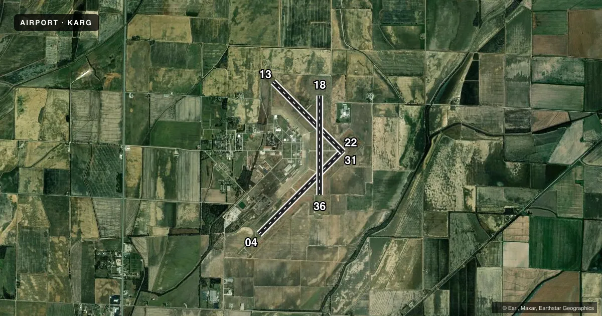
Runways & pattern
Full pagePattern entry · RWY 18
LEFT TRAFFIC| Runway | Heading (°M) | Length | Surface | Traffic |
|---|---|---|---|---|
| 04/22 | 44° / 224° | 6,001 ft | ASPH | Standard L |
| 13/31 | 134° / 314° | 5,003 ft | CONC | Standard L |
| 18/36Favored | 179° / 359° | 5,001 ft | CONC | Standard L |
Runway end performance
| End | TORA | TODA | ASDA | LDA | VGSI | Approach lights | Obstruction |
|---|---|---|---|---|---|---|---|
| 04 | — | — | — | — | — | MALSF | — |
| 22 | — | — | — | — | PAPI 4-box left(3°) | — | — |
| 13 | — | — | — | — | — | — | 15', road, 600' from thr, 0' R of cntrln, slope 26 |
| 31 | — | — | — | — | — | — | 1', berm, 220' from thr, 0' R of cntrln, slope 20 |
| 18 | — | — | — | — | — | ODALS | 15', road, 1000' from thr, 0' R of cntrln, slope 50 |
Declared distances in feet. TORA = takeoff run available, TODA = takeoff distance, ASDA = accelerate-stop, LDA = landing distance.
Airport sketch
Runways drawn to scale from FAA survey coordinates, rendered over satellite imagery. Not for navigation.
Approaches & charts
ILS · 1
Services on the field
Fuel grades, oxygen, maintenance, ramp storage and lighting — as declared to the FAA by the airport operator.
Fuel & services
- Fuel
- 100LLA
- Oxygen (bottled)
- Not available
- Oxygen (bulk)
- Not available
- Airframe repair
- Major
- Power plant repair
- Major
- Other services
- AFRT,AGRI,INSTR
Ramp & ground
- Transient storage
- Tie-down
- Hangar
- Landing fee
- No fee published
- Customs
- Not available
- Lighting schedule
- SEE RMK
- Beacon schedule
- SS-SR
- Beacon
- White / Green (civil land)(WG)
- Wind indicator
- Lighted
- Segmented circle
- Yes
Fuel & FBOs
Cheapest 100LL and Jet A on the field and nearby. Always confirm with the FBO before taxi.
Airport notes
Surface conditions, obstructions, local procedures, lighting outages and other notes published with each FAA cycle.
General notes
- GOVERNMENT CONTRACT FUEL AVBL.
- AGRICULTURAL OPS ON AND INVOF ARPT APR THRU SEP.
- MIGRATORY BIRDS INVOF ARPT OCT THRU JAN.
- FOR CD CTC MEMPHIS ARTCC AT 901-368-8453/8449.
Lighting notes
- ACTVT MALSF RWY 04; ODALS RWY 18; REIL RWY 18; MIRL RWY 04/22, RWY 18/36 - CTAF.
Fuel notes
- 100LLSELF SVC FUEL AVBL 24 HRS WITH CC/FULL SVC AVBL 0800-1700.
- AJET A SELF SVC FUEL AVBL 24 HRS WITH CC/FULL SVC AVBL 0800-1700.
Other notes
- 1IF ARPT ATTENDANT NOT AVBL, CALL 870-886-5432. FEE CHRG UNLESS PRIOR ARRANGEMENTS MADE.
VFR map & nearby airports
VFR sectional. Tap any ICAO chip to open that airport.
Key facts · KARG
Answer card- ICAO
- KARG
- Name
- WALNUT RIDGE RGNL
- Location
- WALNUT RIDGE, ARKANSAS
- Elevation
- 279 ft MSL
- Traffic pattern altitude
- 1,279 ft MSL (1,000 AGL)
- Control tower
- Non-towered (use CTAF)
- Total runways
- 3
- Longest runway
- 04/22 · 6,001 ft
- Published ILS approaches
- 1
- Published frequencies
- 2
- Magnetic variation
- 1°
- Current flight rules
- VFR
- Current wind
- 180° at 5 kt
- Favored runway now
- RWY 18
Walnut Ridge Regional Airport is in Walnut Ridge, Arkansas. Field elevation is 279 ft MSL. The airport has three runways. The longest is runway 04/22 at 6,001 ft. There is no control tower, so plan to use CTAF 122.8 for all local traffic calls.
The field has one ILS approach to runway 18. Pattern altitude is not published, so use the standard 1,000 ft AGL for light piston operations unless the current Chart Supplement says otherwise. The on-field FBO is Walnut Ridge Regional Airport. It carries 100LL and Jet A Prist. Self-serve fuel is available 24 hours with credit card. Full service is available from 0800 to 1700. If the airport attendant is not available, call the airport number before you arrive.
A few local items matter here. Agricultural operations occur on and near the apron through September. Migratory birds are in the area from October through January. Runway lighting is published on 04, 18 and 04/22 plus 18/36, so check the lighting setup before a night arrival. Clearance delivery goes through Memphis ARTCC. For a first-time arrival, the big items are the non-towered pattern work, the active ag traffic and the bird activity in season.