METAR & TAF KCVK
KCVK does not publish a METAR.
Showing the nearest reporting station: KARG (WALNUT RIDGE RGNL) · 32.0 NM away. Conditions at KCVK may differ.
METAR · KARG
Observed 17:56Z
KARG 271756Z AUTO 25008KT 10SM CLR 33/27 A2990 RMK AO2 SLP121 T03330267 10333 20256 58020 $
- Wind
- 250° @ 8 kt
- Visibility
- 10 SM
- Temp / Dew
- 33°C / 27°C
- Altimeter
- 29.90 inHg
- Clouds
- CLR
- Density alt
- 3,074 ft
- Ceiling
- Unlimited
- Rules
- VFR
Airport info & contacts
Manager on record, flight service, ARTCC, attendance schedule and pattern altitude — published by the FAA and refreshed every 28 days.
Location
- From city
- 3 NM NE
- VFR sectional
- KANSAS CITY
- ARTCC
- ZME · MEMPHIS
- NOTAM facility
- JBR (NOTAM-D)
Airport manager
- Name
- JOHN MANNING
- Phone
- 870-751-0248
- Address
- 20 AIRPORT LANE, CHEROKEE VILLAGE AR 72529
Flight service · Hours
- FSS JBR
- JONESBORO1-800-WX-BRIEF
- Attendance
- MON-FRI · 0800-1600
Frequencies
Tap any row to copy the frequency to your clipboard.
Runways & pattern
Full pagePattern entry · RWY 22
LEFT TRAFFICRunway end performance
| End | TORA | TODA | ASDA | LDA | VGSI | Approach lights | Obstruction |
|---|---|---|---|---|---|---|---|
| 04 | — | — | — | — | PAPI 2-box left(3°) | — | — |
| 22 | — | — | — | — | PAPI 2-box left(3°) | — | — |
Declared distances in feet. TORA = takeoff run available, TODA = takeoff distance, ASDA = accelerate-stop, LDA = landing distance.
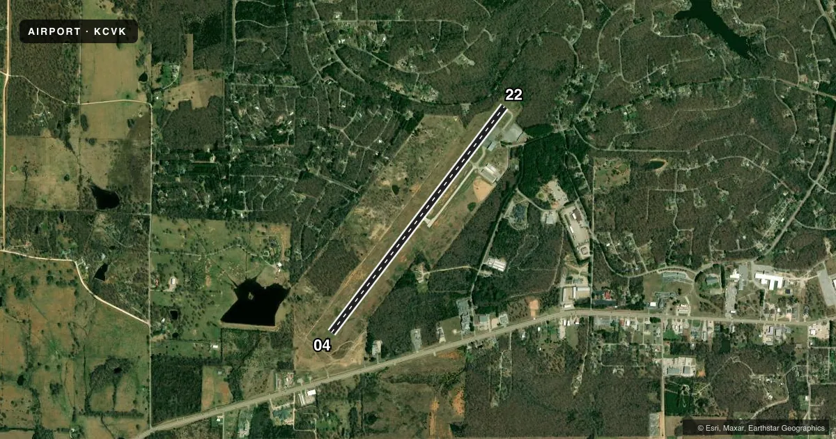
Airport sketch
Runways drawn to scale from FAA survey coordinates, rendered over satellite imagery. Not for navigation.
Approaches & charts
Services on the field
Fuel grades, oxygen, maintenance, ramp storage and lighting — as declared to the FAA by the airport operator.
Fuel & services
- Fuel
- 100LLA
- Airframe repair
- Major
- Power plant repair
- Major
Ramp & ground
- Transient storage
- Tie-down
- Landing fee
- No fee published
- Customs
- Not available
- Lighting schedule
- SEE RMK
- Beacon schedule
- SS-SR
- Beacon
- White / Green (civil land)(WG)
- Wind indicator
- Lighted
- Segmented circle
- Yes
Fuel & FBOs
Cheapest 100LL and Jet A on the field and nearby. Always confirm with the FBO before taxi.
Airport notes
Surface conditions, obstructions, local procedures, lighting outages and other notes published with each FAA cycle.
General notes
- RY 22 HAS 15+ FT DROP OFF 150 FT FM END OF PAVEMENT (304 FT FM DSPLCD THLD).
- FOR CD CTC MEMPHIS ARTCC AT 901-368-8453/8449.
Lighting notes
- ACTVT MIRL RY 04/22 - CTAF.
Fuel notes
- 100LLSELF-SERVICE FUEL AVBL 24 HRS WITH CREDIT CARD (100LL & JET A)
Approach & departure obstructions
- 22APCH SLOPE 50:1 TO DSPLCD THLD.
VFR map & nearby airports
VFR sectional. Tap any ICAO chip to open that airport.
Key facts · KCVK
Answer card- ICAO
- KCVK
- Name
- SHARP COUNTY RGNL
- Location
- ASH FLAT, ARKANSAS
- Elevation
- 717.1 ft MSL
- Traffic pattern altitude
- 1,717.1 ft MSL (1,000 AGL)
- Control tower
- Non-towered (use CTAF)
- Total runways
- 1
- Longest runway
- 04/22 · 5,158 ft
- Published ILS approaches
- 0
- Published frequencies
- 2
- Magnetic variation
- 2°
- Current flight rules
- VFR
- Current wind
- 250° at 8 kt
- Favored runway now
- RWY 22
Sharp County Regional Airport sits in Ash Flat, Arkansas. The field elevation is 717.1 ft MSL. It has one runway. Runway 04/22 is 5,158 ft long with asphalt pavement. There is no control tower. CTAF and UNICOM are both 122.7.
No ILS approaches are published here. The published pattern altitude is not listed, so use the standard 1,000 ft AGL for light piston operations unless the current Chart Supplement says otherwise. The airport is served by Sharp County Regional Airport Authority on the field. It carries AVGAS 100LL and Jet A Prist. Self-service fuel is available 24 hours with credit card for 100LL and Jet A.
A few local items matter on arrival. Runway 22 has a significant drop off beyond the pavement, with the published note calling out a 15 plus foot drop off near the departure end. The approach slope to the displaced threshold on 22 is 50 to 1. Runway lights for 04/22 are activated by CTAF. For clearance delivery, contact Memphis ARTCC before departure. If you are planning a night or low-visibility arrival, verify the lighting and runway condition in the current Chart Supplement and with the airport operator before you go.