METAR & TAF M70
M70 does not publish a METAR.
Showing the nearest reporting station: KARG (WALNUT RIDGE RGNL) · 7.4 NM away. Conditions at M70 may differ.
METAR · KARG
Observed 14:56Z
KARG 271456Z AUTO 15010KT 10SM CLR 29/24 A2996 RMK AO2 SLP142 T02940244 58001 $
- Wind
- 150° @ 10 kt
- Visibility
- 10 SM
- Temp / Dew
- 29°C / 24°C
- Altimeter
- 29.96 inHg
- Clouds
- CLR
- Density alt
- 1,969 ft
- Ceiling
- Unlimited
- Rules
- VFR
Airport info & contacts
Manager on record, flight service, ARTCC, attendance schedule and pattern altitude — published by the FAA and refreshed every 28 days.
Location
- From city
- 1 NM SE
- VFR sectional
- ST LOUIS
- ARTCC
- ZME · MEMPHIS
- NOTAM facility
- JBR (NOTAM-D)
Airport manager
- Name
- CHRIS WHEELER
- Phone
- 870-248-1141
- Address
- 2006 AIRWAYS LANE, POCAHONTAS AR 72455
Flight service · Hours
- FSS JBR
- JONESBORO1-800-WX-BRIEF
- Attendance
- 0800-1700
Frequencies
Tap any row to copy the frequency to your clipboard.
Runways & pattern
Full pagePattern entry · RWY 18
LEFT TRAFFICRunway end performance
| End | TORA | TODA | ASDA | LDA | VGSI | Approach lights | Obstruction |
|---|---|---|---|---|---|---|---|
| 18 | — | — | — | — | PAPI 2-box left(3°) | — | 38', tree, 660' from thr, 330' R of cntrln, slope 12 |
| 36 | — | — | — | — | PAPI 2-box left(3°) | — | 15', road, 480' from thr, 0' R of cntrln, slope 18 |
Declared distances in feet. TORA = takeoff run available, TODA = takeoff distance, ASDA = accelerate-stop, LDA = landing distance.
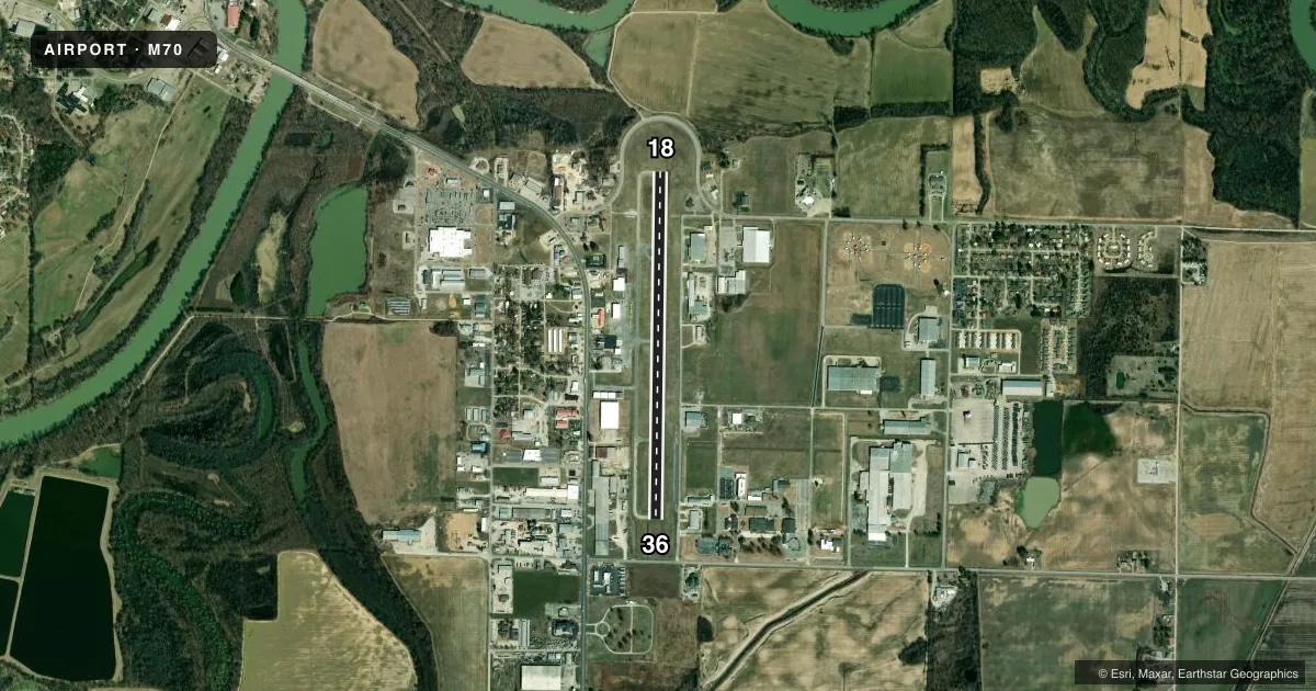
Airport sketch
Runways drawn to scale from FAA survey coordinates, rendered over satellite imagery. Not for navigation.
Approaches & charts
Services on the field
Fuel grades, oxygen, maintenance, ramp storage and lighting — as declared to the FAA by the airport operator.
Fuel & services
- Fuel
- 100LLA
- Oxygen (bottled)
- Not available
- Oxygen (bulk)
- Not available
- Airframe repair
- Major
- Power plant repair
- Major
- Other services
- AGRI,AMB,INSTR
Ramp & ground
- Transient storage
- Tie-down
- Landing fee
- No fee published
- Customs
- Not available
- Lighting schedule
- SEE RMK
- Beacon schedule
- SS-SR
- Beacon
- White / Green (civil land)(WG)
- Wind indicator
- Lighted
- Segmented circle
- Yes
Fuel & FBOs
Cheapest 100LL and Jet A on the field and nearby. Always confirm with the FBO before taxi.
Airport notes
Surface conditions, obstructions, local procedures, lighting outages and other notes published with each FAA cycle.
General notes
- FOR CD CTC MEMPHIS ARTCC AT 901-368-8453/8449.
Lighting notes
- ACTVT REIL RWY 18 & 36; MIRL RWY 18/36 - CTAF. PAPI RWY 18 & 36 OPER CONS.
Fuel notes
- 100LL24 HR SELF SVC FUEL AVBL WITH CREDIT CARD (100LL & JET A)
- AFULL SVC AVBL (JET A).
Other notes
- 1FOR SRVC AFTR HRS CALL 870-260-8283
VFR map & nearby airports
VFR sectional. Tap any ICAO chip to open that airport.
Key facts · M70
Answer card- ICAO
- M70
- Name
- POCAHONTAS MUNI
- Location
- POCAHONTAS, ARKANSAS
- Elevation
- 273.3 ft MSL
- Traffic pattern altitude
- 1,273.3 ft MSL (1,000 AGL)
- Control tower
- Non-towered (use CTAF)
- Total runways
- 1
- Longest runway
- 18/36 · 4,000 ft
- Published ILS approaches
- 0
- Published frequencies
- 2
- Magnetic variation
- 1°
- Current flight rules
- VFR
- Current wind
- 150° at 10 kt
- Favored runway now
- RWY 18
Pocahontas Muni sits in Pocahontas, Arkansas. Field elevation is 273.3 ft MSL. The airport has one runway. Runway 18/36 is 4,000 ft long with asphalt pavement. The field is non-towered. CTAF and UNICOM are both 122.8. No ILS approaches are published here. Pattern altitude is not published, so verify the current Chart Supplement before flying the pattern.
The on-field FBO is Pocahontas Municipal Airport. It carries 100LL and Jet A. The published remarks say 24-hour self-service fuel is available with a credit card for both fuels. Jet A full service is also available. If you need service after hours, call the number in the Chart Supplement before arrival.
Runway 18 and 36 have runway end identifier lights. Medium intensity runway lights are controlled by CTAF. Precision approach path indicators operate continuously on both ends. For a first visit, plan for a simple single-runway setup with no published ILS. Clearance delivery is handled through Memphis ARTCC, so get that sorted early if you need it. The airport sits in northeast Arkansas, so watch the current weather and any local visibility or wind issues before you go.