METAR & TAF X33
X33 does not publish a METAR.
Showing the nearest reporting station: KPOF (POPLAR BLUFF RGNL BUSINESS) · 22.6 NM away. Conditions at X33 may differ.
METAR · KPOF
Observed 16:53Z
KPOF 271653Z AUTO 22011KT 10SM CLR 32/24 A2991 RMK AO2 SLP120 T03170244 $
- Wind
- 220° @ 11 kt
- Visibility
- 10 SM
- Temp / Dew
- 32°C / 24°C
- Altimeter
- 29.91 inHg
- Clouds
- CLR
- Density alt
- 2,840 ft
- Ceiling
- Unlimited
- Rules
- VFR
Airport info & contacts
Manager on record, flight service, ARTCC, attendance schedule and pattern altitude — published by the FAA and refreshed every 28 days.
Location
- From city
- 5 NM NNE
- VFR sectional
- ST LOUIS
- ARTCC
- ZME · MEMPHIS
- NOTAM facility
- STL (NOTAM-D)
Airport manager
- Name
- JARRET FICKE
- Phone
- 573-996-6934
- Address
- 110 NORTH GRAND AVENUE, DONIPHAN MO 63935
Flight service · Hours
- FSS STL
- SAINT LOUIS1-800-WX-BRIEF
- Attendance
- IREG
Frequencies
Tap any row to copy the frequency to your clipboard.
Runways & pattern
Full pagePattern entry · RWY 25
RIGHT TRAFFICRunway end performance
| End | TORA | TODA | ASDA | LDA | VGSI | Approach lights | Obstruction |
|---|---|---|---|---|---|---|---|
| 07 | — | — | — | — | — | — | 75', trees, 760' from thr, 0' R of cntrln, slope 7 |
| 25 | — | — | — | — | — | — | 10', trees, 290' from thr, 75' R of cntrln, slope 9 |
Declared distances in feet. TORA = takeoff run available, TODA = takeoff distance, ASDA = accelerate-stop, LDA = landing distance.
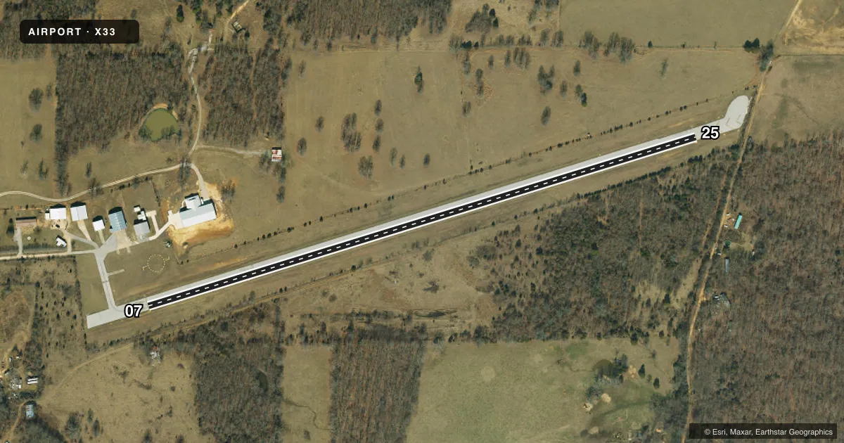
Airport sketch
Runways drawn to scale from FAA survey coordinates, rendered over satellite imagery. Not for navigation.
Approaches & charts
Services on the field
Fuel grades, oxygen, maintenance, ramp storage and lighting — as declared to the FAA by the airport operator.
Fuel & services
- Fuel
- Not available
- Airframe repair
- Minor
- Power plant repair
- Minor
Ramp & ground
- Transient storage
- Tie-down
- Lighting schedule
- SEE RMK
- Wind indicator
- Yes
- Segmented circle
- Yes
Fuel & FBOs
Cheapest 100LL and Jet A on the field and nearby. Always confirm with the FBO before taxi.
Airport notes
Surface conditions, obstructions, local procedures, lighting outages and other notes published with each FAA cycle.
General notes
- WILDLIFE MAY BE ON RYS MORNING & EVENING HRS.
- FOR CD CTC MEMPHIS ARTCC AT 901-368-8453/8449.
Lighting notes
- ACTVT LIRL RWY 07/25 - CTAF.
Runway surface & condition
- 07/25RWY 7/25 THR LTG NSTD DUE TO LCTN, COLOR OF LGTS, NR OF LGTS.
- 07/25WIDTH VARIANCE 57-60 FT.
Approach & departure obstructions
- 07+1-2 FT GND 0-75 FT FM RWY RELCTD THLD 100-125 FT LEFT.
- 25RWY 25 +1-2 BRUSH & HIGH GND; 0-200 FT FM RWY END; 100-125 FT RIGHT; TREES & +1-10 FT BRUSH; 100-200 FT FM RWY END; 100-125 FT LEFT.
- 07APCH RATIO 13:1 TO DSPLCD THLD
Other notes
- SEE LETTER DEC 30, 1988.
VFR map & nearby airports
VFR sectional. Tap any ICAO chip to open that airport.
Key facts · X33
Answer card- ICAO
- X33
- Name
- DONIPHAN MUNI
- Location
- DONIPHAN, MISSOURI
- Elevation
- 635 ft MSL
- Traffic pattern altitude
- 1,635 ft MSL (1,000 AGL)
- Control tower
- Non-towered (use CTAF)
- Total runways
- 1
- Longest runway
- 07/25 · 2,560 ft
- Published ILS approaches
- 0
- Published frequencies
- 1
- Magnetic variation
- 3°
- Current flight rules
- VFR
- Current wind
- 220° at 11 kt
- Favored runway now
- RWY 25
Doniphan Muni (X33) sits in Doniphan, Missouri. Field elevation is 635 ft MSL. The airport has one runway. Runway 07/25 is 2,560 ft long and asphalt. There is no control tower. CTAF is 122.9. No ILS approaches are published here.
Pattern altitude is not published. Use the standard 1,000 ft AGL unless the current Chart Supplement says otherwise. That puts the pattern at 1,635 ft MSL based on the field elevation. The runway lighting is nonstandard at the thresholds, so brief yourself before night work. Low intensity runway lights on 07/25 are activated by CTAF. Wildlife may be on the runway during morning and evening hours.
There are no on-field FBOs listed in the facts. Contact the airport operator directly before arrival if you need fuel or ground support. Runway 25 has brush, high ground and trees near the departure end. Runway 07 has a ground obstruction near the displaced threshold. The runway width varies between 57 and 60 feet. This is a small uncontrolled field, so plan your spacing. Watch your arrival path. Check the current Chart Supplement if you need the latest notes before you go.