METAR & TAF KPOF
Current METAR
Observed 16:53Z
KPOF 271653Z AUTO 22011KT 10SM CLR 32/24 A2991 RMK AO2 SLP120 T03170244 $
- Wind
- 220° @ 11 kt
- Visibility
- 10 SM
- Temp / Dew
- 32°C / 24°C
- Altimeter
- 29.91 inHg
- Clouds
- CLR
- Density alt
- 2,463 ft
- Ceiling
- Unlimited
- Rules
- VFR
Airport info & contacts
Manager on record, flight service, ARTCC, attendance schedule and pattern altitude — published by the FAA and refreshed every 28 days.
Location
- From city
- 3 NM E
- VFR sectional
- ST LOUIS
- ARTCC
- ZME · MEMPHIS
- NOTAM facility
- POF (NOTAM-D)
Airport manager
- Name
- GARY PRIDE
- Phone
- 573-686-8669
- Address
- 101 OAK STREET, POPLAR BLUFF MO 63901
Flight service · Hours
- FSS STL
- SAINT LOUIS1-800-WX-BRIEF
- Attendance
- 0700-1600
Frequencies
Tap any row to copy the frequency to your clipboard.
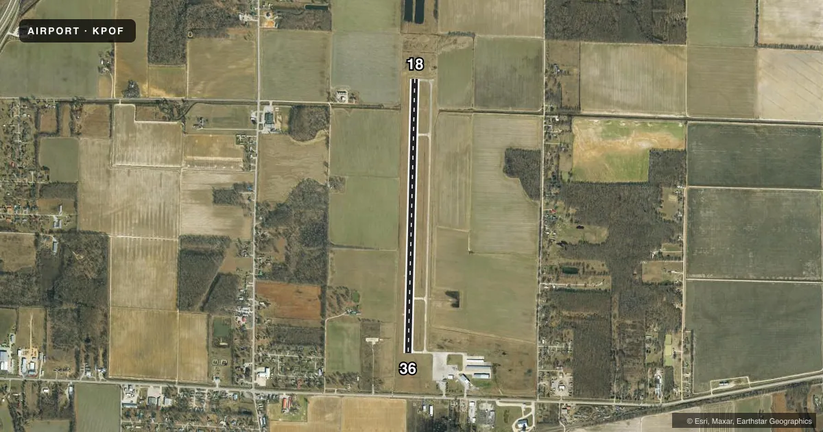
Runways & pattern
Full pagePattern entry · RWY 18
LEFT TRAFFICRunway end performance
| End | TORA | TODA | ASDA | LDA | VGSI | Approach lights | Obstruction |
|---|---|---|---|---|---|---|---|
| 18 | — | — | — | — | PAPI 4-box left(3°) | — | — |
| 36 | — | — | — | — | VASI 4-box left(3°) | — | — |
Declared distances in feet. TORA = takeoff run available, TODA = takeoff distance, ASDA = accelerate-stop, LDA = landing distance.
Airport sketch
Runways drawn to scale from FAA survey coordinates, rendered over satellite imagery. Not for navigation.
Approaches & charts
Services on the field
Fuel grades, oxygen, maintenance, ramp storage and lighting — as declared to the FAA by the airport operator.
Fuel & services
- Fuel
- 100LLA
- Oxygen (bottled)
- Not available
- Oxygen (bulk)
- Not available
- Airframe repair
- Major
- Power plant repair
- Major
- Other services
- AFRT,CHTR,INSTR,RNTL,SALES,SURV
Ramp & ground
- Transient storage
- Tie-down
- Hangar
- Landing fee
- No fee published
- Customs
- Not available
- Lighting schedule
- SEE RMK
- Beacon schedule
- SS-SR
- Beacon
- White / Green (civil land)(WG)
- Wind indicator
- Lighted
- Segmented circle
- Yes
Fuel & FBOs
Cheapest 100LL and Jet A on the field and nearby. Always confirm with the FBO before taxi.
Airport notes
Surface conditions, obstructions, local procedures, lighting outages and other notes published with each FAA cycle.
General notes
- CROP DUSTING ACFT ON & INVOF ARPT FM MARCH TO AUGUST.
- FOR CD CTC MEMPHIS ARTCC AT 901-368-8453/8449.
Lighting notes
- MIRL RWY 18/36, SS-SR; CTAF TO CHG INTST; 7 CLICKS FOR HIGH, 5 CLICKS FOR MED OR LWR INTST. VASI RWY 36 & PAPI RWY 18 - CTAF.
Approach & departure obstructions
- 36RWY 36 APCH SLOPE 28:1 TO DSPLCD THLD.
VFR map & nearby airports
VFR sectional. Tap any ICAO chip to open that airport.
Key facts · KPOF
Answer card- ICAO
- KPOF
- Name
- POPLAR BLUFF RGNL BUSINESS
- Location
- POPLAR BLUFF, MISSOURI
- Elevation
- 330.8 ft MSL
- Traffic pattern altitude
- 1,330.8 ft MSL (1,000 AGL)
- Control tower
- Non-towered (use CTAF)
- Total runways
- 1
- Longest runway
- 18/36 · 5,008 ft
- Published ILS approaches
- 0
- Published frequencies
- 2
- Magnetic variation
- 0°
- Current flight rules
- VFR
- Current wind
- 220° at 11 kt
- Favored runway now
- RWY 18
Poplar Bluff Rgnl Business is in Poplar Bluff, Missouri. Field elevation is 330.8 ft MSL. The airport has one runway, 18/36, which is 5,008 ft long. It is an untowered field, so plan to self-announce on CTAF 123.0. No ILS approaches are published here. Pattern altitude is not published, so use the standard 1,000 ft AGL for light piston traffic unless the current Chart Supplement says otherwise.
The on-field FBO is Poplar Bluff Municipal Airport. It carries 100LL and Jet A. Call (573) 686-8669 before arrival if you need current service details. Medium intensity runway lights are available on runway 18/36 from sunset to sunrise. Use CTAF to change intensity. The field also has a VASI on runway 36 and a PAPI on runway 18.
One item to watch is the runway 36 approach slope note in the Chart Supplement. Crop dusting aircraft also operate on and near the airport from March through August. For clearance delivery, Memphis ARTCC is listed in the remarks. If you are planning a night arrival or a first visit, review the current Chart Supplement and expect normal non-towered traffic flow on 123.0.