METAR & TAF KTKX
Current METAR
Observed 17:15Z
KTKX 271715Z AUTO 25013KT 10SM CLR 34/29 A2988 RMK AO2
- Wind
- 250° @ 13 kt
- Visibility
- 10 SM
- Temp / Dew
- 34°C / 29°C
- Altimeter
- 29.88 inHg
- Clouds
- CLR
- Density alt
- 2,654 ft
- Ceiling
- Unlimited
- Rules
- VFR
Airport info & contacts
Manager on record, flight service, ARTCC, attendance schedule and pattern altitude — published by the FAA and refreshed every 28 days.
Location
- From city
- 1 NM SE
- VFR sectional
- ST LOUIS
- ARTCC
- ZME · MEMPHIS
- NOTAM facility
- STL (NOTAM-D)
Airport manager
- Name
- SAMMY JEWELL
- Phone
- 573-888-5846
- Address
- PO BOX 623, KENNETT MO 63857
Flight service · Hours
- FSS STL
- SAINT LOUIS1-800-WX-BRIEF
- Attendance
- MON-SAT · 0800-1700
- SUN · 1300-1700
Frequencies
Tap any row to copy the frequency to your clipboard.
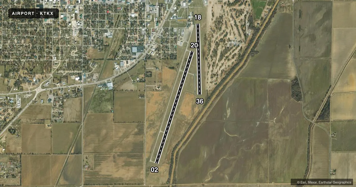
Runways & pattern
Full pagePattern entry · RWY 20
LEFT TRAFFIC| Runway | Heading (°M) | Length | Surface | Traffic |
|---|---|---|---|---|
| 02/20Favored | 18° / 198° | 5,000 ft | CONC | 02 R |
| 18/36 | 179° / 359° | 3,012 ft | ASPH | 36 R |
Runway end performance
| End | TORA | TODA | ASDA | LDA | VGSI | Approach lights | Obstruction |
|---|---|---|---|---|---|---|---|
| 02 | — | — | — | — | PAPI 4-box left(3°) | — | 43', tree, 1065' from thr, 300' R of cntrln, slope 20 |
| 20 | — | — | — | — | PAPI 4-box left(3°) | — | 45', tree, 1560' from thr, 390' R of cntrln, slope 30 |
| 36 | — | — | — | — | — | — | 33', trees, 543' from thr, 140' R of cntrln, slope 10 |
Declared distances in feet. TORA = takeoff run available, TODA = takeoff distance, ASDA = accelerate-stop, LDA = landing distance.
Airport sketch
Runways drawn to scale from FAA survey coordinates, rendered over satellite imagery. Not for navigation.
Approaches & charts
Services on the field
Fuel grades, oxygen, maintenance, ramp storage and lighting — as declared to the FAA by the airport operator.
Fuel & services
- Fuel
- 100LLA
- Oxygen (bottled)
- Not available
- Oxygen (bulk)
- Not available
- Airframe repair
- Major
- Power plant repair
- Major
- Other services
- RNTL
Ramp & ground
- Transient storage
- Tie-down
- Landing fee
- No fee published
- Customs
- Not available
- Lighting schedule
- SEE RMK
- Beacon schedule
- SS-SR
- Beacon
- White / Green (civil land)(WG)
- Wind indicator
- Lighted
- Segmented circle
- Yes
Fuel & FBOs
Cheapest 100LL and Jet A on the field and nearby. Always confirm with the FBO before taxi.
Airport notes
Surface conditions, obstructions, local procedures, lighting outages and other notes published with each FAA cycle.
General notes
- AIRPORT PHONE (573) 888-1339.
- FOR CD CTC MEMPHIS ARTCC AT 901-368-8453/8449.
Lighting notes
- MIRL RYS 18/36 & 02/20 ON LOW INTST DUSK-0300; TO INCR INTST & ACTVT MIRL RYS 18/36 & 02/20 & REIL RYS 02; 20 FM 2300-DAWN - CTAF. PAPI RYS 02 & 20 ON 24 HRS.
VFR map & nearby airports
VFR sectional. Tap any ICAO chip to open that airport.
Key facts · KTKX
Answer card- ICAO
- KTKX
- Name
- KENNETT MEML
- Location
- KENNETT, MISSOURI
- Elevation
- 261.8 ft MSL
- Traffic pattern altitude
- 1,261.8 ft MSL (1,000 AGL)
- Control tower
- Non-towered (use CTAF)
- Total runways
- 2
- Longest runway
- 02/20 · 5,000 ft
- Published ILS approaches
- 0
- Published frequencies
- 2
- Magnetic variation
- 0°
- Current flight rules
- VFR
- Current wind
- 250° at 13 kt
- Favored runway now
- RWY 20
Kennett Memorial Airport sits in Kennett, Missouri. The field elevation is 261.8 ft MSL. It has two runways. The longest is 5,000 ft on runway 02/20. The airport is non-towered. CTAF and UNICOM are both 122.8.
No ILS approaches are published here. Pattern altitude is not published, so use the standard 1,000 ft AGL for light piston operations unless the current Chart Supplement says otherwise. The on-field FBO is Kennett Memorial Airport. It carries 100LL and Jet A Prist. Call the airport at (573) 888-1339 for current service details.
Runway 02/20 has medium intensity lights that run low intensity from dusk to 0300. From 2300 to dawn, use the CTAF to raise light intensity and turn on the runway end identifier lights for 02 and 20. Precision approach path indicators are available on 02 and 20 around the clock. For clearance delivery, Memphis ARTCC is listed in the remarks. First-time pilots should plan for a quiet non-towered field with simple comms, then verify any current procedures in the FAA Chart Supplement before departure.