METAR & TAF 7M4
7M4 does not publish a METAR.
Showing the nearest reporting station: KHKA (BLYTHEVILLE MUNI) · 17.3 NM away. Conditions at 7M4 may differ.
METAR · KHKA
Observed 12:53Z
KHKA 271253Z AUTO 15007KT 10SM CLR 26/22 A2997 RMK AO2 SLP145 T02610217 PWINO $
- Wind
- 150° @ 7 kt
- Visibility
- 10 SM
- Temp / Dew
- 26°C / 22°C
- Altimeter
- 29.97 inHg
- Clouds
- CLR
- Density alt
- 1,549 ft
- Ceiling
- Unlimited
- Rules
- VFR
Airport info & contacts
Manager on record, flight service, ARTCC, attendance schedule and pattern altitude — published by the FAA and refreshed every 28 days.
Location
- From city
- 2 NM SW
- VFR sectional
- MEMPHIS
- ARTCC
- ZME · MEMPHIS
- NOTAM facility
- JBR (NOTAM-D)
Airport manager
- Name
- JUSTIN BAGLEY
- Phone
- 870-763-0200
- Address
- 200 COUNTRY CLUB ROAD, OSCEOLA AR 72370
Flight service · Hours
- FSS JBR
- JONESBORO1-800-WX-BRIEF
- Attendance
- Unattended
Frequencies
Tap any row to copy the frequency to your clipboard.
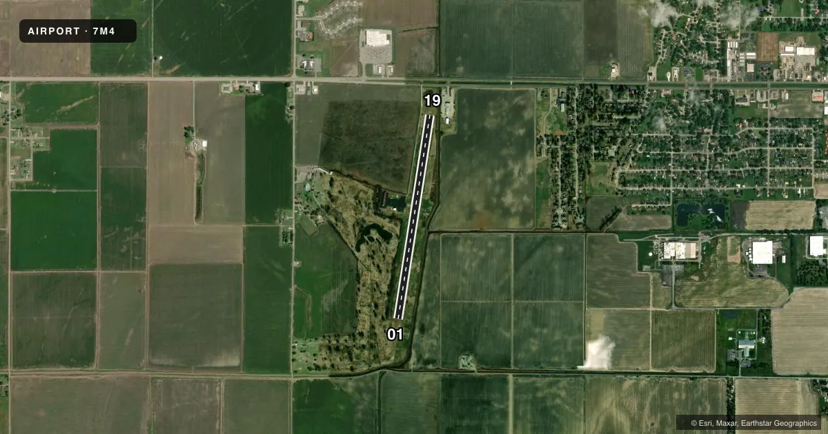
Runways & pattern
Full pagePattern entry · RWY 19
LEFT TRAFFICRunway end performance
| End | TORA | TODA | ASDA | LDA | VGSI | Approach lights | Obstruction |
|---|---|---|---|---|---|---|---|
| 01 | — | — | — | — | — | — | 25', tree, 815' from thr, 275' R of cntrln, slope 24 |
| 19 | — | — | — | — | PAPI 2-box left(3°) | — | 31', pole, 550' from thr, 380' R of cntrln, slope 11 |
Declared distances in feet. TORA = takeoff run available, TODA = takeoff distance, ASDA = accelerate-stop, LDA = landing distance.
Airport sketch
Runways drawn to scale from FAA survey coordinates, rendered over satellite imagery. Not for navigation.
Approaches & charts
Services on the field
Fuel grades, oxygen, maintenance, ramp storage and lighting — as declared to the FAA by the airport operator.
Fuel & services
- Fuel
- 100LL
- Oxygen (bottled)
- Not available
- Oxygen (bulk)
- Not available
- Airframe repair
- Not available
- Power plant repair
- Not available
- Other services
- AGRI
Ramp & ground
- Transient storage
- Tie-down
- Hangar
- Landing fee
- No fee published
- Customs
- Not available
- Lighting schedule
- SEE RMK
- Beacon schedule
- SS-SR
- Beacon
- White / Green (civil land)(WG)
- Wind indicator
- Lighted
- Segmented circle
- Yes
Fuel & FBOs
Cheapest 100LL and Jet A on the field and nearby. Always confirm with the FBO before taxi.
Airport notes
Surface conditions, obstructions, local procedures, lighting outages and other notes published with each FAA cycle.
General notes
- FOR CD CTC MEMPHIS APCH AT 901-842-8457.
Lighting notes
- ACTVT REIL RWY 19; MIRL RWY 01/19 - CTAF.
Fuel notes
- 100LLFUEL AVBL 24 HRS WITH CREDIT CARD.
Other notes
- IF HARWELL ARPT IS CLSD.
- 1FOR ARPT ATTENDANT CALL 870-532-7309.
VFR map & nearby airports
VFR sectional. Tap any ICAO chip to open that airport.
Key facts · 7M4
Answer card- ICAO
- 7M4
- Name
- OSCEOLA MUNI
- Location
- OSCEOLA, ARKANSAS
- Elevation
- 234.7 ft MSL
- Traffic pattern altitude
- 1,234.7 ft MSL (1,000 AGL)
- Control tower
- Non-towered (use CTAF)
- Total runways
- 1
- Longest runway
- 01/19 · 3,799 ft
- Published ILS approaches
- 0
- Published frequencies
- 4
- Magnetic variation
- 2°
- Current flight rules
- VFR
- Current wind
- 150° at 7 kt
- Favored runway now
- RWY 19
Osceola Muni sits in Osceola, Arkansas. Field elevation is 234.7 ft MSL. The airport has one runway. Runway 01/19 is 3,799 ft of asphalt. There is no control tower. Pattern altitude is not published, so light piston traffic should plan on the standard 1,000 ft AGL unless the current Chart Supplement says otherwise.
No ILS approaches are published here. Memphis Approach handles the approach and departure side on the listed frequencies. The field is a simple setup, but the lighting details matter at night. Runway 19 has REIL lighting. Medium intensity runway lighting is available on both runway ends and is controlled by CTAF.
Osceola Municipal Airport is the on-field FBO. It carries 100LL. Fuel is available 24 hours with credit card. For airport attendant service, call the number listed in the remarks. If you are planning a stop because Harwell Airport is closed, verify the current field status before you launch. This is a low-elevation Arkansas airport with no tower, so expect self-announce traffic and standard local coordination on CTAF.