METAR & TAF 6M8
6M8 does not publish a METAR.
Showing the nearest reporting station: KJBR (JONESBORO MUNI) · 21.6 NM away. Conditions at 6M8 may differ.
METAR · KJBR
Observed 15:53Z
KJBR 271553Z AUTO 17009KT 10SM CLR 32/24 A2995 RMK AO2 SLP136 T03170239 PWINO $
- Wind
- 170° @ 9 kt
- Visibility
- 10 SM
- Temp / Dew
- 32°C / 24°C
- Altimeter
- 29.95 inHg
- Clouds
- CLR
- Density alt
- 2,274 ft
- Ceiling
- Unlimited
- Rules
- VFR
Airport info & contacts
Manager on record, flight service, ARTCC, attendance schedule and pattern altitude — published by the FAA and refreshed every 28 days.
Location
- From city
- 1 NM E
- VFR sectional
- MEMPHIS
- ARTCC
- ZME · MEMPHIS
- NOTAM facility
- JBR (NOTAM-D)
Airport manager
- Name
- WAYNE HENDRIX
- Phone
- (870) 375-3025
- Address
- 1 ELM STREET, MARKED TREE AR 72365
Flight service · Hours
- FSS JBR
- JONESBORO1-800-WX-BRIEF
- Attendance
- IREG
Frequencies
Tap any row to copy the frequency to your clipboard.
Runways & pattern
Full pagePattern entry · RWY 18
LEFT TRAFFICRunway end performance
| End | TORA | TODA | ASDA | LDA | VGSI | Approach lights | Obstruction |
|---|---|---|---|---|---|---|---|
| 18 | — | — | — | — | PAPI 2-box left(3°) | — | — |
| 36 | — | — | — | — | PAPI 2-box left(3°) | — | 15', road, 500' from thr, 0' R of cntrln, slope 20 |
Declared distances in feet. TORA = takeoff run available, TODA = takeoff distance, ASDA = accelerate-stop, LDA = landing distance.
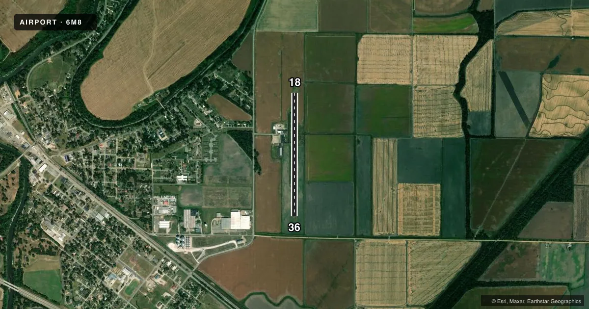
Airport sketch
Runways drawn to scale from FAA survey coordinates, rendered over satellite imagery. Not for navigation.
Approaches & charts
Services on the field
Fuel grades, oxygen, maintenance, ramp storage and lighting — as declared to the FAA by the airport operator.
Fuel & services
- Fuel
- Not available
- Airframe repair
- Not available
- Power plant repair
- Not available
- Other services
- AGRI
Ramp & ground
- Transient storage
- Tie-down
- Hangar
- Landing fee
- No fee published
- Customs
- Not available
- Lighting schedule
- SEE RMK
- Beacon schedule
- SS-SR
- Beacon
- White / Green (civil land)(WG)
- Wind indicator
- Lighted
- Segmented circle
- Yes
Fuel & FBOs
Cheapest 100LL and Jet A on the field and nearby. Always confirm with the FBO before taxi.
Airport notes
Surface conditions, obstructions, local procedures, lighting outages and other notes published with each FAA cycle.
General notes
- NUMEROUS AGRICULTURAL ACFT OPNS FM FEB-NOV 500 FT AGL AND BELOW.
- FOR CD CTC MEMPHIS APCH AT 901-842-8457.
Lighting notes
- ACTVT MIRL RY 18/36 - CTAF.
Other notes
- 1FOR SVC AFT HRS CALL 870-358-2024.
VFR map & nearby airports
VFR sectional. Tap any ICAO chip to open that airport.
Key facts · 6M8
Answer card- ICAO
- 6M8
- Name
- MARKED TREE MUNI
- Location
- MARKED TREE, ARKANSAS
- Elevation
- 219 ft MSL
- Traffic pattern altitude
- 1,219 ft MSL (1,000 AGL)
- Control tower
- Non-towered (use CTAF)
- Total runways
- 1
- Longest runway
- 18/36 · 3,200 ft
- Published ILS approaches
- 0
- Published frequencies
- 2
- Magnetic variation
- 2°
- Current flight rules
- VFR
- Current wind
- 170° at 9 kt
- Favored runway now
- RWY 18
Marked Tree Muni is in Marked Tree, Arkansas. The field elevation is 219 ft MSL. It has one runway. Runway 18/36 is 3,200 ft of asphalt, so plan your landing distance with that length in mind.
There is no control tower. CTAF is 122.8. The same frequency is listed for UNICOM. Medium intensity runway lights on 18/36 are activated by using the common traffic advisory frequency. No ILS approaches are published here, so check the current FAA Chart Supplement and your approach setup before you go.
The pattern altitude is not published. Use the standard 1,000 ft AGL for light piston traffic unless ATC or the current Chart Supplement says otherwise. Clearance delivery is handled through Memphis Approach at 901-842-8457. After-hours service is available by phone at 870-358-2024.
One operational item matters here. Agricultural aircraft activity is common from February through November and it can be down at 500 ft AGL and below. Expect to keep a sharp scan in the pattern and on departure. There are no on-field FBOs listed in the facts, so contact the airport operator directly before arrival, or call the field on CTAF/UNICOM for current FBO availability.