METAR & TAF 8M2
8M2 does not publish a METAR.
Showing the nearest reporting station: KJBR (JONESBORO MUNI) · 19.5 NM away. Conditions at 8M2 may differ.
METAR · KJBR
Observed 03:53Z
KJBR 270353Z AUTO 21004KT 10SM CLR 29/26 A2991 RMK AO2 SLP126 T02940261 $
- Wind
- 210° @ 4 kt
- Visibility
- 10 SM
- Temp / Dew
- 29°C / 26°C
- Altimeter
- 29.91 inHg
- Clouds
- CLR
- Density alt
- 1,996 ft
- Ceiling
- Unlimited
- Rules
- VFR
Airport info & contacts
Manager on record, flight service, ARTCC, attendance schedule and pattern altitude — published by the FAA and refreshed every 28 days.
Location
- From city
- 3 NM S
- VFR sectional
- MEMPHIS
- ARTCC
- ZME · MEMPHIS
- NOTAM facility
- JBR (NOTAM-D)
Airport manager
- Name
- CORY JOHNSON
- Phone
- (870) 930-4555
- Address
- PO BOX 46, WEINER AR 72749
Flight service · Hours
- FSS JBR
- JONESBORO1-800-WX-BRIEF
- Attendance
- Unattended
Frequencies
Tap any row to copy the frequency to your clipboard.
Runways & pattern
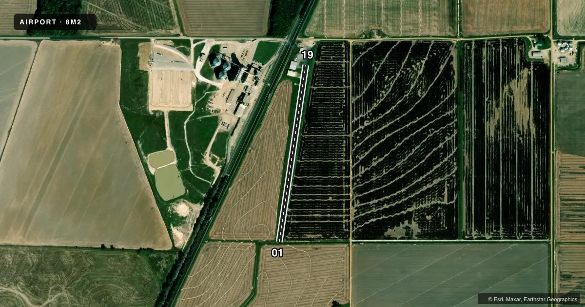
Full pagePattern entry · RWY 19
LEFT TRAFFICAirport sketch
Runways drawn to scale from FAA survey coordinates, rendered over satellite imagery. Not for navigation.
Approaches & charts
Services on the field
Fuel grades, oxygen, maintenance, ramp storage and lighting — as declared to the FAA by the airport operator.
Fuel & services
- Fuel
- Not available
- Airframe repair
- Not available
- Power plant repair
- Not available
- Other services
- AGRI
Ramp & ground
- Transient storage
- Tie-down
- Landing fee
- No fee published
- Wind indicator
- Yes
- Segmented circle
- No
Fuel & FBOs
Cheapest 100LL and Jet A on the field and nearby. Always confirm with the FBO before taxi.
Airport notes
Surface conditions, obstructions, local procedures, lighting outages and other notes published with each FAA cycle.
General notes
- NUMEROUS AGRICULTURAL ACFT OPNS.
- FOR CD CTC MEMPHIS ARTCC AT 901-368-8453/8449.
Runway surface & condition
- 01/19RWY 01/19 2000 FT X 28 FT ASPH SUPERIMPOSED ON RWY 19 END, REMAINDER TURF.
Approach & departure obstructions
- 19ROAD 60' FM NORTH END OF RY.
Other notes
- ESTAB PRIOR TO 1959.
VFR map & nearby airports
VFR sectional. Tap any ICAO chip to open that airport.
Key facts · 8M2
Answer card- ICAO
- 8M2
- Name
- SALLY WOFFORD
- Location
- WEINER, ARKANSAS
- Elevation
- 245 ft MSL
- Traffic pattern altitude
- 1,245 ft MSL (1,000 AGL)
- Control tower
- Non-towered (use CTAF)
- Total runways
- 1
- Longest runway
- 01/19 · 2,330 ft
- Published ILS approaches
- 0
- Published frequencies
- 1
- Magnetic variation
- 3°
- Current flight rules
- VFR
- Current wind
- 210° at 4 kt
- Favored runway now
- RWY 19
Sally Wofford Airport (8M2) sits in Weiner, Arkansas. Field elevation is 245 ft MSL. The airport has one runway. Runway 01/19 is 2,330 ft long with asphalt-turf surface. The published runway note says the 19 end has asphalt superimposed. The rest is turf. There is no control tower. CTAF is 122.9. No ILS approaches are published.
Pattern altitude is not published. Use 1,000 ft AGL for light piston operations unless the current Chart Supplement says otherwise. That puts the pattern at 1,245 ft MSL based on the field elevation. The airport has a published remark that numerous agricultural aircraft operations occur. Expect that traffic mix to matter more than usual here. A road is also noted 60 ft from the north end of runway 19, so pay attention on the southbound end of the strip.
There are no on-field FBOs listed. Plan on confirming services with the airport operator or by phone before you go. For clearance delivery, Memphis ARTCC is the published contact. This is a small, non-towered field with a short runway and mixed surfaces. It is the kind of place where a current briefing matters more than assumptions.