METAR & TAF M60
M60 does not publish a METAR.
Showing the nearest reporting station: KSRC (SEARCY RGNL) · 23.2 NM away. Conditions at M60 may differ.
METAR · KSRC
Observed 16:56Z
KSRC 271656Z AUTO VRB04KT 10SM CLR 35/26 A2994 RMK AO2 SLP135 T03500261 $
- Wind
- VAR @ 4 kt
- Visibility
- 10 SM
- Temp / Dew
- 35°C / 26°C
- Altimeter
- 29.94 inHg
- Clouds
- CLR
- Density alt
- 2,623 ft
- Ceiling
- Unlimited
- Rules
- VFR
Airport info & contacts
Manager on record, flight service, ARTCC, attendance schedule and pattern altitude — published by the FAA and refreshed every 28 days.
Location
- From city
- 4 NM E
- VFR sectional
- MEMPHIS
- ARTCC
- ZME · MEMPHIS
- NOTAM facility
- JBR (NOTAM-D)
Airport manager
- Name
- MICHAEL-JOHN GRAY - CO. JUDGE
- Phone
- 870-731-5516
- Address
- P.O. BOX 300, AUGUSTA AR 72006
Flight service · Hours
- FSS JBR
- JONESBORO1-800-WX-BRIEF
- Attendance
- Unattended
Frequencies
Tap any row to copy the frequency to your clipboard.
Runways & pattern
Full pagePattern entry · RWY 27
LEFT TRAFFICRunway end performance
| End | TORA | TODA | ASDA | LDA | VGSI | Approach lights | Obstruction |
|---|---|---|---|---|---|---|---|
| 09 | — | — | — | — | PAPI 2-box left(3°) | — | 4', road, 300' from thr, 0' R of cntrln, slope 25 |
| 27 | — | — | — | — | PAPI 2-box left(3.04°) | — | 30', trees, 850' from thr, 75' R of cntrln, slope 21 |
Declared distances in feet. TORA = takeoff run available, TODA = takeoff distance, ASDA = accelerate-stop, LDA = landing distance.
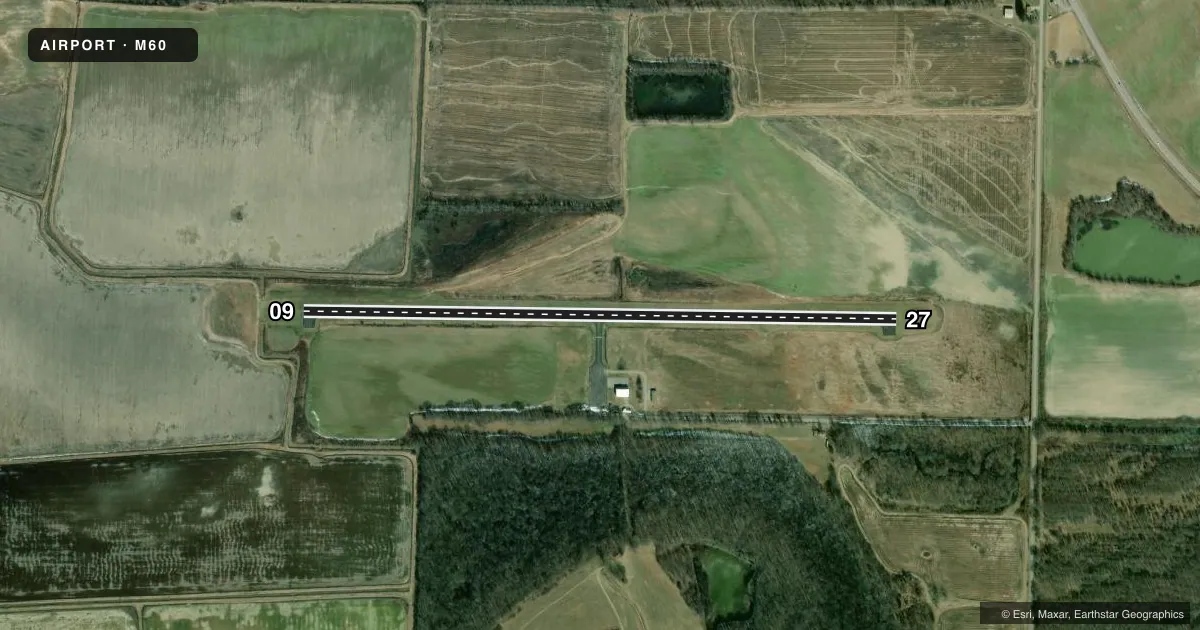
Airport sketch
Runways drawn to scale from FAA survey coordinates, rendered over satellite imagery. Not for navigation.
Approaches & charts
Services on the field
Fuel grades, oxygen, maintenance, ramp storage and lighting — as declared to the FAA by the airport operator.
Fuel & services
- Fuel
- Not available
- Airframe repair
- Not available
- Power plant repair
- Not available
- Other services
- AGRI
Ramp & ground
- Transient storage
- Tie-down
- Landing fee
- No fee published
- Lighting schedule
- SEE RMK
- Beacon schedule
- SS-SR
- Beacon
- White / Green (civil land)(WG)
- Wind indicator
- Lighted
- Segmented circle
- Yes
Fuel & FBOs
Cheapest 100LL and Jet A on the field and nearby. Always confirm with the FBO before taxi.
Airport notes
Surface conditions, obstructions, local procedures, lighting outages and other notes published with each FAA cycle.
General notes
- DEER ON & INVOF ARPT.
- FOR CD CTC MEMPHIS ARTCC AT 901-368-8453/8449.
Lighting notes
- ACTVT MIRL RY 09/27 - CTAF.
VFR map & nearby airports
VFR sectional. Tap any ICAO chip to open that airport.
Key facts · M60
Answer card- ICAO
- M60
- Name
- WOODRUFF COUNTY
- Location
- AUGUSTA, ARKANSAS
- Elevation
- 200 ft MSL
- Traffic pattern altitude
- 1,200 ft MSL (1,000 AGL)
- Control tower
- Non-towered (use CTAF)
- Total runways
- 1
- Longest runway
- 09/27 · 3,797 ft
- Published ILS approaches
- 0
- Published frequencies
- 1
- Magnetic variation
- 1°
- Current flight rules
- VFR
- Current wind
- 000° at 4 kt
- Favored runway now
- RWY 27
Woodruff County Airport (M60) sits in Augusta, Arkansas. Field elevation is 200 ft MSL. The airport has one runway. Runway 09/27 is 3,797 ft long with an asphalt surface. There is no control tower. CTAF is 122.9.
No ILS approaches are published here. Pattern altitude is not published, so use the standard 1,000 ft AGL for light piston traffic unless the current Chart Supplement says otherwise. The field is a simple non-towered stop, so keep your scan tight in the pattern and listen well on CTAF. Medium intensity runway lights on 09/27 are activated by the common traffic advisory frequency. That helps for night arrivals, but you still need to verify lighting status before you go.
Deer are reported on and near the airport. That is the main local hazard to plan for, especially at dawn and dusk. For clearance delivery, Memphis ARTCC is listed in the remarks with the published phone numbers. There are no on-field FBOs listed in the facts, so contact the airport operator directly before arrival if you need fuel or ramp details.