METAR & TAF KSRC
Current METAR
Observed 18:56Z
KSRC 271856Z AUTO 20008KT 10SM CLR 36/24 A2988 RMK AO2 SLP115 T03610244 $
- Wind
- 200° @ 8 kt
- Visibility
- 10 SM
- Temp / Dew
- 36°C / 24°C
- Altimeter
- 29.88 inHg
- Clouds
- CLR
- Density alt
- 2,898 ft
- Ceiling
- Unlimited
- Rules
- VFR
Airport info & contacts
Manager on record, flight service, ARTCC, attendance schedule and pattern altitude — published by the FAA and refreshed every 28 days.
Location
- From city
- 3 NM S
- VFR sectional
- MEMPHIS
- Pattern altitude
- 800 ft AGL · 1,065 ft MSL
- ARTCC
- ZME · MEMPHIS
- NOTAM facility
- SRC (NOTAM-D)
Airport manager
- Name
- ROGER PEARSON
- Phone
- 501-279-1080
- Address
- 2609 S MAIN, SEARCY AR 72143
Flight service · Hours
- FSS JBR
- JONESBORO1-800-WX-BRIEF
- Attendance
- 0700-1800
Frequencies
Tap any row to copy the frequency to your clipboard.
Runways & pattern
Full pagePattern entry · RWY 19
LEFT TRAFFICRunway end performance
| End | TORA | TODA | ASDA | LDA | VGSI | Approach lights | Obstruction |
|---|---|---|---|---|---|---|---|
| 01 | — | — | — | — | PAPI 4-box left(3°) | MALSR | — |
| 19 | — | — | — | — | PAPI 4-box left(3°) | — | 25', tree, 1050' from thr, 300' R of cntrln, slope 34 |
Declared distances in feet. TORA = takeoff run available, TODA = takeoff distance, ASDA = accelerate-stop, LDA = landing distance.
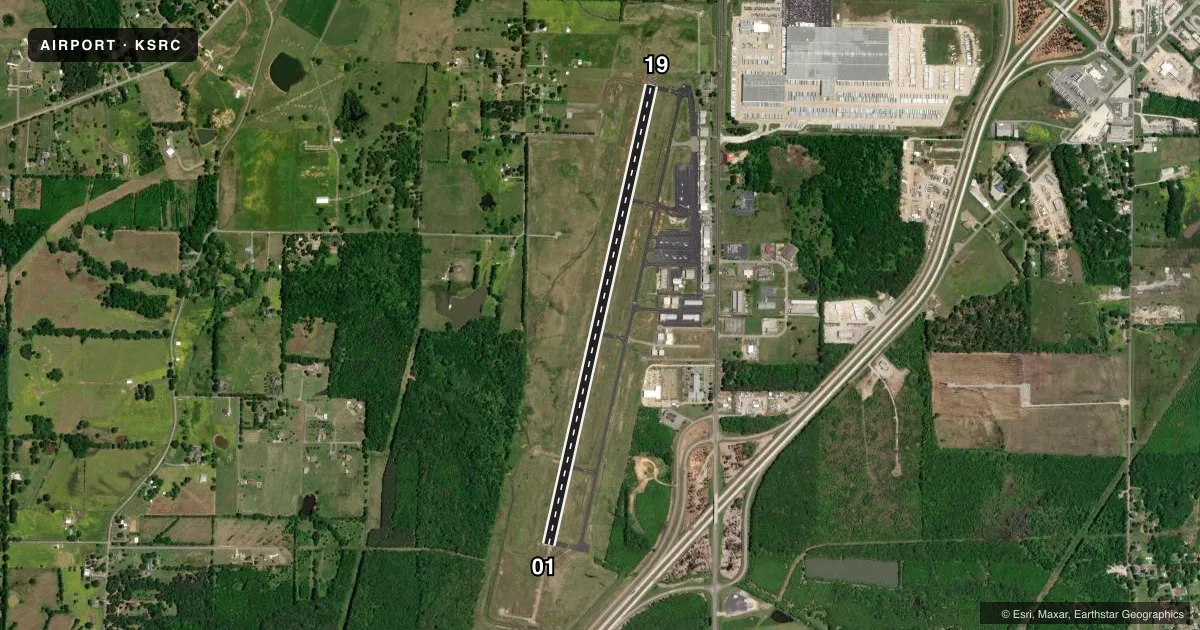
Airport sketch
Runways drawn to scale from FAA survey coordinates, rendered over satellite imagery. Not for navigation.
Approaches & charts
ILS · 1
Services on the field
Fuel grades, oxygen, maintenance, ramp storage and lighting — as declared to the FAA by the airport operator.
Fuel & services
- Fuel
- 100LLA
- Oxygen (bottled)
- High pressure
- Oxygen (bulk)
- High pressure
- Airframe repair
- Major
- Power plant repair
- Major
- Other services
- AGRI,AMB,INSTR,RNTL,SALES
Ramp & ground
- Transient storage
- Tie-down
- Hangar
- Landing fee
- No fee published
- Customs
- Not available
- Lighting schedule
- SEE RMK
- Beacon schedule
- SS-SR
- Beacon
- White / Green (civil land)(WG)
- Wind indicator
- Lighted
- Segmented circle
- No
Fuel & FBOs
Cheapest 100LL and Jet A on the field and nearby. Always confirm with the FBO before taxi.
Airport notes
Surface conditions, obstructions, local procedures, lighting outages and other notes published with each FAA cycle.
General notes
- NMRS AGRICULTURAL ACFT OPNS FM FEB-NOV 500 FT AGL & BLW.
- NMRS GYROCOPTER OPNS DALGT HRS.
- NMRS STUDENT PILOT OPNS.
- NO LINE OF SIGHT BTN RWY ENDS - SMALL ACFT.
- FOR CD WHEN UNA VIA FREQ CTC LITTLE ROCK APCH 501-379-2908 OR LITTLE ROCK ATCT 501-379-2911.
Lighting notes
- DUSK-DAWN. MIRL RWY 01/19 PRESET LOW INTST; TO INCR INTST ACTVT - CTAF.
Fuel notes
- 100LL100LL AVBL SELF SERVE WITH CREDIT CARD. FOR JET A FUEL OR SVC AFT HRS CALL 501-279-1080.
VFR map & nearby airports
VFR sectional. Tap any ICAO chip to open that airport.
Key facts · KSRC
Answer card- ICAO
- KSRC
- Name
- SEARCY RGNL
- Location
- SEARCY, ARKANSAS
- Elevation
- 264.5 ft MSL
- Traffic pattern altitude
- 1,064.5 ft MSL (800 AGL)
- Control tower
- Non-towered (use CTAF)
- Total runways
- 1
- Longest runway
- 01/19 · 6,008 ft
- Published ILS approaches
- 1
- Published frequencies
- 5
- Magnetic variation
- 2°
- Current flight rules
- VFR
- Current wind
- 200° at 8 kt
- Favored runway now
- RWY 19
Searcy Regional Airport sits in Searcy, Arkansas. Field elevation is 264.5 ft MSL. The airport has one runway, 01/19, which is 6,008 ft long. There is no control tower. Pattern altitude is 800 ft AGL, which is 1,064.5 ft MSL.
Runway 01 has the published ILS approach. The field is used heavily by student pilots. Expect gyrocopter traffic in daylight hours. Agricultural aircraft also operate here from February through November at 500 ft AGL and below. Small aircraft should also plan for limited sightline between runway ends. That matters when you are trying to build situational awareness on the ground.
Lighting is simple but useful. From dusk to dawn, the medium intensity runway lights on 01/19 come up at low intensity by default. Use the CTAF to increase intensity. Searcy Municipal Airport is on the field. It carries AVGAS 100LL and Jet A Prist. Self-serve 100LL is available with a credit card. For Jet A fuel or after-hours service, call the FBO directly at (501) 279-1080. If you need clearance delivery by phone, Little Rock Approach and Little Rock Tower numbers are published in the Chart Supplement. Check the current FAA Chart Supplement for any noise or curfew restrictions before flying into the field.