METAR & TAF KHBZ
KHBZ does not publish a METAR.
Showing the nearest reporting station: KBVX (BATESVILLE RGNL) · 22.0 NM away. Conditions at KHBZ may differ.
METAR · KBVX
Observed 16:56Z
KBVX 271656Z AUTO 13005KT 10SM CLR 34/25 A2995 RMK AO2 SLP138 T03440250 $
- Wind
- 130° @ 5 kt
- Visibility
- 10 SM
- Temp / Dew
- 34°C / 25°C
- Altimeter
- 29.95 inHg
- Clouds
- CLR
- Density alt
- 3,027 ft
- Ceiling
- Unlimited
- Rules
- VFR
Airport info & contacts
Manager on record, flight service, ARTCC, attendance schedule and pattern altitude — published by the FAA and refreshed every 28 days.
Location
- From city
- 2 NM NE
- VFR sectional
- MEMPHIS
- Pattern altitude
- 798 ft AGL · 1,430 ft MSL
- ARTCC
- ZME · MEMPHIS
- NOTAM facility
- JBR (NOTAM-D)
Airport manager
- Name
- CHARLES EVANS
- Phone
- 501-362-3294
- Address
- 2111 AIRPORT RD, HEBER SPRINGS AR 72543
Flight service · Hours
- FSS JBR
- JONESBORO1-800-WX-BRIEF
- Attendance
- 0800-1700
Frequencies
Tap any row to copy the frequency to your clipboard.
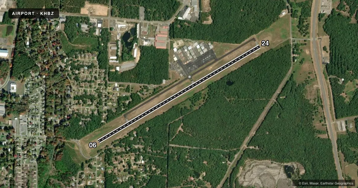
Runways & pattern
Full pagePattern entry · RWY 06
LEFT TRAFFICRunway end performance
| End | TORA | TODA | ASDA | LDA | VGSI | Approach lights | Obstruction |
|---|---|---|---|---|---|---|---|
| 06 | — | — | — | — | PAPI 2-box left(3°) | — | 34', trees, 705' from thr, 180' R of cntrln, slope 14 |
| 24 | — | — | — | — | PAPI 2-box left(3°) | — | — |
Declared distances in feet. TORA = takeoff run available, TODA = takeoff distance, ASDA = accelerate-stop, LDA = landing distance.
Airport sketch
Runways drawn to scale from FAA survey coordinates, rendered over satellite imagery. Not for navigation.
Approaches & charts
Services on the field
Fuel grades, oxygen, maintenance, ramp storage and lighting — as declared to the FAA by the airport operator.
Fuel & services
- Fuel
- 100LLA
- Oxygen (bottled)
- Low pressure
- Oxygen (bulk)
- Not available
- Airframe repair
- Major
- Power plant repair
- Major
- Other services
- INSTR,RNTL
Ramp & ground
- Transient storage
- Tie-down
- Landing fee
- No fee published
- Customs
- Not available
- Lighting schedule
- SEE RMK
- Beacon schedule
- SS-SR
- Beacon
- White / Green (civil land)(WG)
- Wind indicator
- Lighted
- Segmented circle
- Yes
Fuel & FBOs
Cheapest 100LL and Jet A on the field and nearby. Always confirm with the FBO before taxi.
Airport notes
Surface conditions, obstructions, local procedures, lighting outages and other notes published with each FAA cycle.
General notes
- RWY 06/24 NO LINE OF SIGHT BTN RY ENDS.
- FOR CD CTC MEMPHIS ARTCC AT 901-368-8453/8449.
- DEER ON & INVOF ARPT.
Lighting notes
- DUSK-DAWN. ACTVT REIL RWY 06/24 AND MIRL RWY 06/24 - CTAF.
Fuel notes
- 100LLSELF-SERVICE FUEL AVBL 24 HRS WITH CREDIT CARD (100LL & JET A)
Other notes
- THIS AIRPORT HAS BEEN SURVEYED BY THE NATIONAL GEODETIC SURVEY.
VFR map & nearby airports
VFR sectional. Tap any ICAO chip to open that airport.
Key facts · KHBZ
Answer card- ICAO
- KHBZ
- Name
- HEBER SPRINGS MUNI
- Location
- HEBER SPRINGS, ARKANSAS
- Elevation
- 632.3 ft MSL
- Traffic pattern altitude
- 1,430.3 ft MSL (798 AGL)
- Control tower
- Non-towered (use CTAF)
- Total runways
- 1
- Longest runway
- 06/24 · 4,002 ft
- Published ILS approaches
- 0
- Published frequencies
- 2
- Magnetic variation
- 0°
- Current flight rules
- VFR
- Current wind
- 130° at 5 kt
- Favored runway now
- RWY 06
Heber Springs Muni sits in Heber Springs, Arkansas. Field elevation is 632.3 ft MSL. The airport has one runway. Runway 06/24 is 4,002 ft of asphalt, so plan your performance with that length in mind. There is no control tower. CTAF and UNICOM are both 122.7.
Pattern altitude is 798 ft AGL, which is 1,430.3 ft MSL. No ILS approaches are published here, so check the current FAA Chart Supplement and your approach options before you go. The published remarks also matter here. Runway end identifier lights and medium intensity runway lights on 06/24 are activated from dusk to dawn on the CTAF. Self-service fuel is available 24 hours with credit card for 100LL and Jet A. The airport also notes that runway 06/24 has no line of sight between runway ends. Deer are on and near the field, so keep a sharp scan on taxi, takeoff and landing.
Heber Springs Municipal Airport is the on-field FBO. It carries AVGAS 100LL and Jet A Prist. For clearance delivery, contact Memphis ARTCC before departure if you need it. First-time arrivals should also review the current Chart Supplement for any operational notes before flying in.