METAR & TAF 2A2
2A2 does not publish a METAR.
Showing the nearest reporting station: KCCA (CLINTON MUNI) · 3.9 NM away. Conditions at 2A2 may differ.
METAR · KCCA
Observed 13:15Z
KCCA 271315Z AUTO 00000KT 10SM CLR 27/24 A2998 RMK AO2
- Wind
- 000° @ 0 kt
- Visibility
- 10 SM
- Temp / Dew
- 27°C / 24°C
- Altimeter
- 29.98 inHg
- Clouds
- CLR
- Density alt
- 2,940 ft
- Ceiling
- Unlimited
- Rules
- VFR
Airport info & contacts
Manager on record, flight service, ARTCC, attendance schedule and pattern altitude — published by the FAA and refreshed every 28 days.
Location
- From city
- 5 NM NE
- VFR sectional
- MEMPHIS
- ARTCC
- ZME · MEMPHIS
- NOTAM facility
- JBR (NOTAM-D)
Airport manager
- Name
- MIKE FOOTE
- Phone
- 501-253-4590
- Address
- 302 NORTHRIDGE RD., CLINTON AR 72031
Flight service · Hours
- FSS JBR
- JONESBORO1-800-WX-BRIEF
- Attendance
- UNATTENDED
Frequencies
Tap any row to copy the frequency to your clipboard.
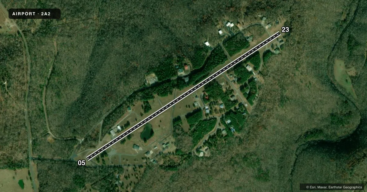
Runways & pattern
Full pagePattern entry · RWY 05
LEFT TRAFFICRunway end performance
| End | TORA | TODA | ASDA | LDA | VGSI | Approach lights | Obstruction |
|---|---|---|---|---|---|---|---|
| 05 | — | — | — | — | VASI 2-box left(3.5°) | — | 50', trees, 500' from thr, 35' R of cntrln, slope 6 |
| 23 | — | — | — | — | PAPI 2-box left(3°) | — | 5', trees, 360' from thr, 120' R of cntrln, slope 32 |
Declared distances in feet. TORA = takeoff run available, TODA = takeoff distance, ASDA = accelerate-stop, LDA = landing distance.
Airport sketch
Runways drawn to scale from FAA survey coordinates, rendered over satellite imagery. Not for navigation.
Approaches & charts
Services on the field
Fuel grades, oxygen, maintenance, ramp storage and lighting — as declared to the FAA by the airport operator.
Fuel & services
- Fuel
- Not available
Ramp & ground
- Transient storage
- Not published
- Lighting schedule
- SEE RMK
- Beacon schedule
- SS-SR
- Beacon
- White / Green (civil land)(WG)
- Wind indicator
- Lighted
- Segmented circle
- No
Fuel & FBOs
Cheapest 100LL and Jet A on the field and nearby. Always confirm with the FBO before taxi.
Airport notes
Surface conditions, obstructions, local procedures, lighting outages and other notes published with each FAA cycle.
General notes
- DEER ON & INVOF RY.
- RY 05/23 CLSD TO ACFT GROSS WT GREATER THAN 12,500 LBS.
- FOR CD CTC MEMPHIS ARTCC AT 901-368-8453/8449.
- WX INFO - CTAF (6 CLICKS).
- BEGINNING 10 FT BYD EAST END OF RWY 23 PAVEMENT, GND HAS APRX 10FT DROP OVER 40 FT LEN.
- BEGINNING 50 FT BYD WEST END OF RWY 5 PAVEMENT, GND HAS APRX 25 FT DROP OVER 125 FT LEN.
Lighting notes
- ACTVT REIL RWYS 05 & 23; VASI RWY 05; MIRL RWY 05/23 - CTAF.
Approach & departure obstructions
- 05VASI UNUSABLE BYD 2 DEGS LEFT & 7 DEGS RIGHT OF CENTERLINE.
- 05APCH SLOPE 18:1 TO DTHR.
VFR map & nearby airports
VFR sectional. Tap any ICAO chip to open that airport.
Key facts · 2A2
Answer card- ICAO
- 2A2
- Name
- HOLLEY MOUNTAIN AIRPARK
- Location
- CLINTON, ARKANSAS
- Elevation
- 1,270 ft MSL
- Traffic pattern altitude
- 2,270 ft MSL (1,000 AGL)
- Control tower
- Non-towered (use CTAF)
- Total runways
- 1
- Longest runway
- 05/23 · 4,795 ft
- Published ILS approaches
- 0
- Published frequencies
- 2
- Magnetic variation
- 2°
- Current flight rules
- VFR
- Current wind
- 000° at 0 kt
- Favored runway now
- –
Holley Mountain Airpark sits near Clinton, Arkansas. Field elevation is 1,270 ft MSL. The airport has one runway. Runway 05/23 is 4,795 ft long and asphalt. There is no control tower. CTAF and UNICOM are both 122.7. No ILS approaches are published here.
Pattern altitude is not published. Use the standard 1,000 ft AGL pattern unless local procedures or current Chart Supplement remarks say otherwise. The field has runway end identifier lights on 05 and 23. Medium intensity runway lights are also on 05 and 23. They are controlled by CTAF. A visual approach slope indicator is on runway 05. The remarks also note a drop in terrain beyond the west end of runway 5. There is a smaller drop beyond the east end of runway 23. Deer are reported on and near the runway, so a careful scan on taxi, takeoff and landing is smart.
There are no on-field FBOs listed in the facts. Contact the airport operator or the FBO directly by phone before arrival if you need fuel or handling. Runway 05/23 is closed to aircraft over 12,500 lb gross weight. For clearance delivery, Memphis ARTCC is the contact listed in the Chart Supplement. Weather information is available on CTAF by keying the microphone six times.