METAR & TAF 12A
12A does not publish a METAR.
Showing the nearest reporting station: KCXW (CONWAY RGNL) · 14.4 NM away. Conditions at 12A may differ.
METAR · KCXW
Observed 16:35Z
KCXW 271635Z AUTO 25008KT 10SM CLR 36/24 A2993 RMK A01
- Wind
- 250° @ 8 kt
- Visibility
- 10 SM
- Temp / Dew
- 36°C / 24°C
- Altimeter
- 29.93 inHg
- Clouds
- CLR
- Density alt
- 2,916 ft
- Ceiling
- Unlimited
- Rules
- VFR
Airport info & contacts
Manager on record, flight service, ARTCC, attendance schedule and pattern altitude — published by the FAA and refreshed every 28 days.
Location
- From city
- 5 NM SE
- VFR sectional
- MEMPHIS
- ARTCC
- ZME · MEMPHIS
- NOTAM facility
- JBR (NOTAM-D)
Airport manager
- Name
- BILL HOOTEN
- Phone
- 501-514-0204
- Address
- 52 CESSNA AVE., GREENBRIER AR 72058
Flight service · Hours
- FSS JBR
- JONESBORO1-800-WX-BRIEF
- Attendance
- Unattended
Frequencies
Tap any row to copy the frequency to your clipboard.
Runways & pattern
Full pagePattern entry · RWY 18
LEFT TRAFFICRunway end performance
| End | TORA | TODA | ASDA | LDA | VGSI | Approach lights | Obstruction |
|---|---|---|---|---|---|---|---|
| 18 | — | — | — | — | — | — | 70', tree, 240' from thr, 95' R of cntrln, slope 0 |
Declared distances in feet. TORA = takeoff run available, TODA = takeoff distance, ASDA = accelerate-stop, LDA = landing distance.
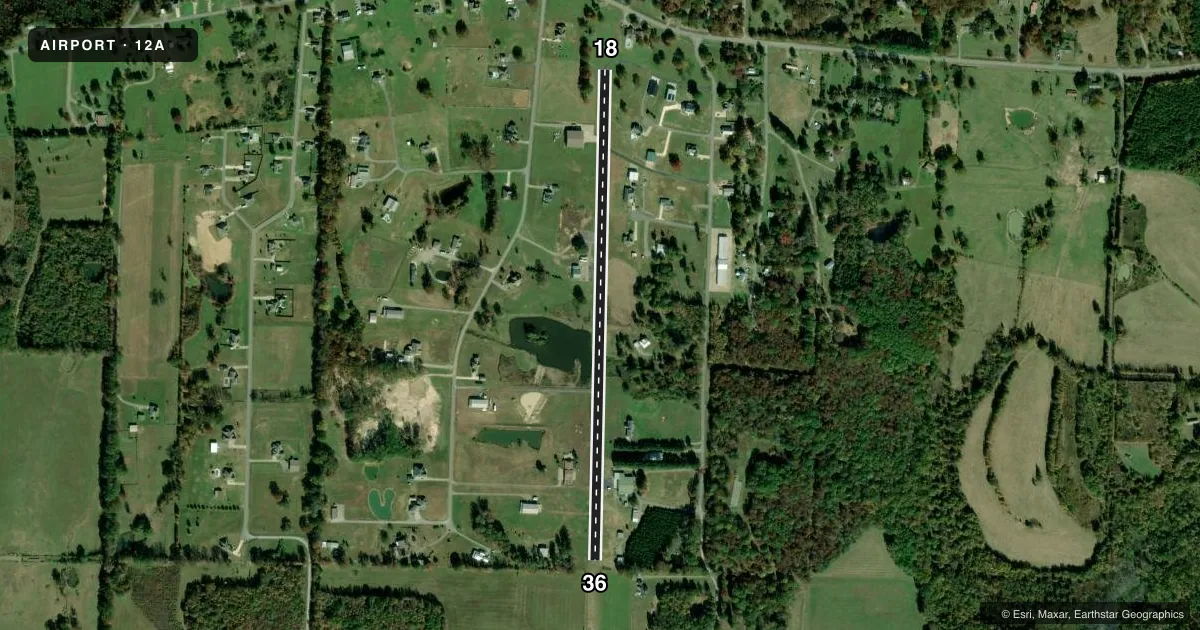
Airport sketch
Runways drawn to scale from FAA survey coordinates, rendered over satellite imagery. Not for navigation.
Approaches & charts
Services on the field
Fuel grades, oxygen, maintenance, ramp storage and lighting — as declared to the FAA by the airport operator.
Fuel & services
- Fuel
- Not available
Ramp & ground
- Transient storage
- Tie-down
- Hangar
- Lighting schedule
- SEE RMK
- Wind indicator
- Yes
- Segmented circle
- No
Fuel & FBOs
Cheapest 100LL and Jet A on the field and nearby. Always confirm with the FBO before taxi.
Airport notes
Surface conditions, obstructions, local procedures, lighting outages and other notes published with each FAA cycle.
General notes
- RISING TERRAIN NORTH END.
- FOR CD CTC LITTLE ROCK APCH 501-379-2908 OR LITTLE ROCK ATCT 501-379-2911.
Lighting notes
- ACTVT MIRL RY 18/36 - CTAF.
Approach & departure obstructions
- 364 FT FENCE 100 FT FM THLD 50 FT L&R.
Other notes
- PRVDD CLEAR 20:1 APCH FOR 5000 FT; CLEAR PRIMARY SURFACE; SUBMIT FORM 7460-1 FOR ANY FUTURE CONSTRUCTION.
- CONTACT WAYNE JAQUES 501 681 4858
VFR map & nearby airports
VFR sectional. Tap any ICAO chip to open that airport.
Key facts · 12A
Answer card- ICAO
- 12A
- Name
- ARKAVALLEY
- Location
- GREENBRIER, ARKANSAS
- Elevation
- 329 ft MSL
- Traffic pattern altitude
- 1,329 ft MSL (1,000 AGL)
- Control tower
- Non-towered (use CTAF)
- Total runways
- 1
- Longest runway
- 18/36 · 3,133 ft
- Published ILS approaches
- 0
- Published frequencies
- 2
- Magnetic variation
- 2°
- Current flight rules
- VFR
- Current wind
- 250° at 8 kt
- Favored runway now
- RWY 18
ARKAVALLEY (12A) is in Greenbrier, Arkansas. Field elevation is 329 ft MSL. The airport has one runway. Runway 18/36 is 3,133 ft long with asphalt surface. There is no control tower. CTAF and UNICOM are both 122.8. No ILS approaches are published here.
Pattern altitude is not published in the facts. Use the standard 1,000 ft AGL pattern for light piston traffic unless the current FAA Chart Supplement says otherwise. The field has rising terrain at the north end. There is also a 4-foot fence about 100 feet from the threshold of runway 36. That is worth keeping in mind on short final. Medium intensity runway lights on 18/36 are activated by CTAF.
No on-field FBOs are listed. Contact the airport operator or the FBO directly by phone before arrival if you need current service details. For clearance delivery, the published remarks point pilots to Little Rock Approach or Little Rock Tower. First-time visitors should also verify any local operating notes in the current FAA Chart Supplement before flying in.