METAR & TAF KMPJ
KMPJ does not publish a METAR.
Showing the nearest reporting station: KBDQ (MORRILTON MUNI) · 9.6 NM away. Conditions at KMPJ may differ.
METAR · KBDQ
Observed 04:15Z
KBDQ 270415Z AUTO 23004KT 10SM CLR 31/22 A2992 RMK AO2
- Wind
- 230° @ 4 kt
- Visibility
- 10 SM
- Temp / Dew
- 31°C / 22°C
- Altimeter
- 29.92 inHg
- Clouds
- CLR
- Density alt
- 3,065 ft
- Ceiling
- Unlimited
- Rules
- VFR
Airport info & contacts
Manager on record, flight service, ARTCC, attendance schedule and pattern altitude — published by the FAA and refreshed every 28 days.
Location
- From city
- 8 NM W
- VFR sectional
- MEMPHIS
- ARTCC
- ZME · MEMPHIS
- NOTAM facility
- JBR (NOTAM-D)
Airport manager
- Name
- JOE BUCKLEY
- Phone
- 501-727-5441
- Address
- 1285 PETIT JEAN MOUNTAIN RD., MORRILTON AR 72110
Flight service · Hours
- FSS JBR
- JONESBORO1-800-WX-BRIEF
- Attendance
- Unattended
Frequencies
Tap any row to copy the frequency to your clipboard.
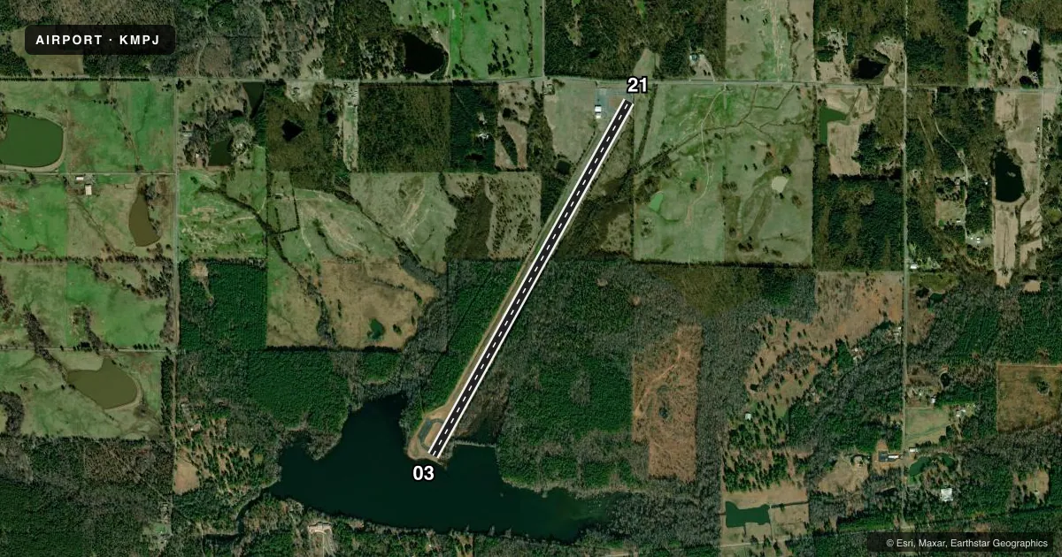
Runways & pattern
Full pagePattern entry · RWY 21
LEFT TRAFFICRunway end performance
| End | TORA | TODA | ASDA | LDA | VGSI | Approach lights | Obstruction |
|---|---|---|---|---|---|---|---|
| 03 | — | — | — | — | PAPI 2-box right(4°) | — | 95', trees, 1530' from thr, 0' R of cntrln, slope 14 |
| 21 | — | — | — | — | PAPI 2-box left(4°) | — | 40', trees, 360' from thr, 200' R of cntrln, slope 4 |
Declared distances in feet. TORA = takeoff run available, TODA = takeoff distance, ASDA = accelerate-stop, LDA = landing distance.
Airport sketch
Runways drawn to scale from FAA survey coordinates, rendered over satellite imagery. Not for navigation.
Approaches & charts
Services on the field
Fuel grades, oxygen, maintenance, ramp storage and lighting — as declared to the FAA by the airport operator.
Fuel & services
- Fuel
- 100LLA
Ramp & ground
- Transient storage
- Tie-down
- Landing fee
- No fee published
- Customs
- Not available
- Lighting schedule
- SEE RMK
- Beacon schedule
- SEE RMK
- Beacon
- White / Green (civil land)(WG)
- Wind indicator
- Yes
- Segmented circle
- No
Fuel & FBOs
Cheapest 100LL and Jet A on the field and nearby. Always confirm with the FBO before taxi.
Airport notes
Surface conditions, obstructions, local procedures, lighting outages and other notes published with each FAA cycle.
General notes
- ULTRALIGHT ACTIVITY ON & INVOF ARPT
- DEER & MIGRATORY BIRDS ON & INVOF ARPT.
- FOR CD CTC MEMPHIS ARTCC AT 901-368-8453/8449.
Lighting notes
- ACTVT ROTG BCN - CTAF. BCN UNAVBL 2200-0400.
- ACTVT PAPI RWY 03 & 21; MIRL RWY 03/21 - CTAF. PAPI RWY 03 & 21 UNAVBL 2200-0400.
Fuel notes
- 100LLSELF SVC FUEL AVBL 24 HR WITH CREDIT CARD (100LL & JET A).
Runway surface & condition
- 03/21MIRL RWY 03/21 OTS INDEFLY.
Approach & departure obstructions
- 033 FT FENCE 50 FT FM RWY END.
- 03RWY 03 NR IS FADED.
- 21RWY 21 NR IS FADED.
- 03PAPI RWY 03/21 OTS INDEFLY.
- 03APCH RATIO 20:1 FM DSPLCD THLD.
- 21APCH RATIO 13:1 FM DSPLCD THLD.
Other notes
- 2FOR SERVICE CALL 501-727-5441
VFR map & nearby airports
VFR sectional. Tap any ICAO chip to open that airport.
Key facts · KMPJ
Answer card- ICAO
- KMPJ
- Name
- PETIT JEAN PARK
- Location
- MORRILTON, ARKANSAS
- Elevation
- 923 ft MSL
- Traffic pattern altitude
- 1,923 ft MSL (1,000 AGL)
- Control tower
- Non-towered (use CTAF)
- Total runways
- 1
- Longest runway
- 03/21 · 5,852 ft
- Published ILS approaches
- 0
- Published frequencies
- 1
- Magnetic variation
- 3°
- Current flight rules
- VFR
- Current wind
- 230° at 4 kt
- Favored runway now
- RWY 21
Petit Jean Park Airport sits near Morrilton, Arkansas. Field elevation is 923 ft MSL. It has one runway, 03/21, which is 5,852 ft long. There is no control tower. CTAF is 122.9.
No ILS approaches are published here. The pattern altitude is not published, so use the standard 1,000 ft AGL for light piston operations unless the current Chart Supplement says otherwise. The published remarks matter here. Runway 03/21 has medium intensity lights that are out of service indefinitely. PAPI on both ends is also out of service indefinitely. The lights and PAPI are activated by CTAF when available. The beacon is also CTAF-activated. It is unavailable from 2200 to 0400.
Self-serve fuel is available 24 hours with credit card for 100LL and Jet A. No on-field FBO is listed, so call the airport operator or the field directly if you need handling or local support. There is also ultralight activity on and near the airport, so keep a sharp scan in the pattern. Runway 03 has a 3 ft fence 50 ft from the runway end. Runway 21 has a published approach clearance slope issue from the displaced threshold. This is a non-towered field with a single asphalt runway, so plan your arrival, monitor CTAF and verify any current lighting or operational changes before you go.