METAR & TAF M19
Current METAR
Observed 17:56Z
KM19 271756Z AUTO 21005KT CLR 34/26 A2991 RMK AO2 SLP137 T03440256 10350 20256 58017 PWINO $
- Wind
- 210° @ 5 kt
- Visibility
- —
- Temp / Dew
- 34°C / 26°C
- Altimeter
- 29.91 inHg
- Clouds
- CLR
- Density alt
- 2,589 ft
- Ceiling
- Unlimited
- Rules
- VFR
Airport info & contacts
Manager on record, flight service, ARTCC, attendance schedule and pattern altitude — published by the FAA and refreshed every 28 days.
Location
- From city
- 5 NM NE
- VFR sectional
- MEMPHIS
- ARTCC
- ZME · MEMPHIS
- NOTAM facility
- M19 (NOTAM-D)
Airport manager
- Name
- THOMAS SANDERS
- Phone
- 870-523-3613
- Address
- 3800 OPERATIONS DRIVE, NEWPORT AR 72112
Flight service · Hours
- FSS JBR
- JONESBORO1-800-WX-BRIEF
- Attendance
- MON-FRI · 0800-1700
- SAT · 0800-1200
Frequencies
Tap any row to copy the frequency to your clipboard.
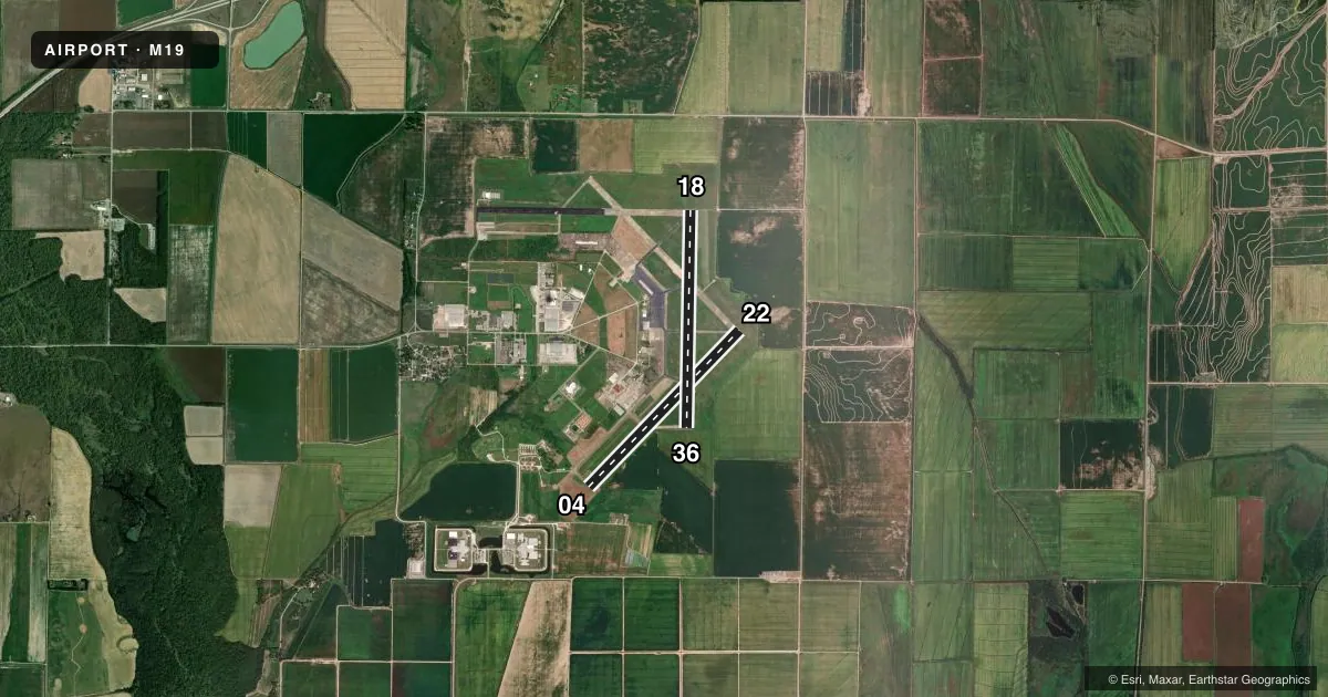
Runways & pattern
Full pagePattern entry · RWY 22
LEFT TRAFFIC| Runway | Heading (°M) | Length | Surface | Traffic |
|---|---|---|---|---|
| 04/22Favored | 44° / 224° | 5,002 ft | CONC | 04 R |
| 18/36 | 181° / 1° | 5,002 ft | CONC | 36 R |
Runway end performance
| End | TORA | TODA | ASDA | LDA | VGSI | Approach lights | Obstruction |
|---|---|---|---|---|---|---|---|
| 18 | — | — | — | — | PAPI 4-box left(3°) | — | 32', pline, 1740' from thr, 0' R of cntrln, slope 48 |
| 36 | — | — | — | — | PAPI 4-box right(3°) | — | — |
Declared distances in feet. TORA = takeoff run available, TODA = takeoff distance, ASDA = accelerate-stop, LDA = landing distance.
Airport sketch
Runways drawn to scale from FAA survey coordinates, rendered over satellite imagery. Not for navigation.
Approaches & charts
Services on the field
Fuel grades, oxygen, maintenance, ramp storage and lighting — as declared to the FAA by the airport operator.
Fuel & services
- Fuel
- 100LLA
- Oxygen (bottled)
- Not available
- Oxygen (bulk)
- Not available
- Airframe repair
- Not available
- Power plant repair
- Not available
- Other services
- AGRI,INSTR
Ramp & ground
- Transient storage
- Tie-down
- Landing fee
- No fee published
- Customs
- Not available
- Lighting schedule
- SEE RMK
- Beacon schedule
- SS-SR
- Beacon
- White / Green (civil land)(WG)
- Wind indicator
- Lighted
- Segmented circle
- No
Fuel & FBOs
Cheapest 100LL and Jet A on the field and nearby. Always confirm with the FBO before taxi.
Airport notes
Surface conditions, obstructions, local procedures, lighting outages and other notes published with each FAA cycle.
General notes
- NUMEROUS AGRICULTURAL OPNS MARCH THRU AUGUST
- FOR CD CTC MEMPHIS ARTCC AT 901-368-8453/8449.
Lighting notes
- DUSK-DAWN. ACTVT MIRL RWY 18/36 - CTAF. REIL RWY 18, RWY 36 OTS TEMPO.
Fuel notes
- 100LLSELF SVC FUEL AVBL AFT HRS WITH CREDIT CARD JET A & 100LL.
Other notes
- PRE DATES THE ACT.
- 1FOR SVC AFT HRS CALL 870-217-1400
VFR map & nearby airports
VFR sectional. Tap any ICAO chip to open that airport.
Key facts · M19
Answer card- ICAO
- M19
- Name
- NEWPORT RGNL
- Location
- NEWPORT, ARKANSAS
- Elevation
- 238.9 ft MSL
- Traffic pattern altitude
- 1,238.9 ft MSL (1,000 AGL)
- Control tower
- Non-towered (use CTAF)
- Total runways
- 2
- Longest runway
- 04/22 · 5,002 ft
- Published ILS approaches
- 0
- Published frequencies
- 2
- Magnetic variation
- 0°
- Current flight rules
- VFR
- Current wind
- 210° at 5 kt
- Favored runway now
- RWY 22
Newport Rgnl sits in Newport, Arkansas. The field elevation is 238.9 ft MSL. It has two runways. Both are 5,002 ft concrete. Runway 04/22 has magnetic headings of 44° and 224°. Runway 18/36 has magnetic headings of 181° and 1°.
There is no control tower. CTAF and UNICOM are both 122.8. No ILS approaches are published. Pattern altitude is not published, so plan on 1,000 ft AGL for light piston traffic unless the current FAA Chart Supplement says otherwise. The airport is in a flat part of Arkansas, so the main local issue is traffic awareness rather than terrain.
Newport Airport Commission is on the field. It carries AVGAS 100LL and Jet A. Call (870) 523-3613 for current service details. Self-service fuel is available after hours with card access for Jet A and 100LL. Lighting runs from dusk to dawn. Medium intensity runway lights are active on runway 18/36 and are controlled by CTAF. The runway end identifier lights on runway 18 and runway 36 are temporarily out of service. Agricultural work is common from March through August, so expect low-level traffic in the area. For clearance delivery, contact Memphis ARTCC before departure.