METAR & TAF KPGR
KPGR does not publish a METAR.
Showing the nearest reporting station: KJBR (JONESBORO MUNI) · 15.4 NM away. Conditions at KPGR may differ.
METAR · KJBR
Observed 16:53Z
KJBR 271653Z AUTO 24007KT 10SM CLR 33/26 A2993 RMK AO2 SLP130 T03330256 PWINO $
- Wind
- 240° @ 7 kt
- Visibility
- 10 SM
- Temp / Dew
- 33°C / 26°C
- Altimeter
- 29.93 inHg
- Clouds
- CLR
- Density alt
- 2,507 ft
- Ceiling
- Unlimited
- Rules
- VFR
Airport info & contacts
Manager on record, flight service, ARTCC, attendance schedule and pattern altitude — published by the FAA and refreshed every 28 days.
Location
- From city
- 1 NM NW
- VFR sectional
- ST LOUIS
- Pattern altitude
- 809 ft AGL · 1,099 ft MSL
- ARTCC
- ZME · MEMPHIS
- NOTAM facility
- JBR (NOTAM-D)
Airport manager
- Name
- ROGER SLAYTON
- Phone
- 870-239-7505
- Address
- 305 AIRPORT ROAD, PARAGOULD AR 72450
Flight service · Hours
- FSS JBR
- JONESBORO1-800-WX-BRIEF
- Attendance
- MON-FRI · 0700-1600
Frequencies
Tap any row to copy the frequency to your clipboard.
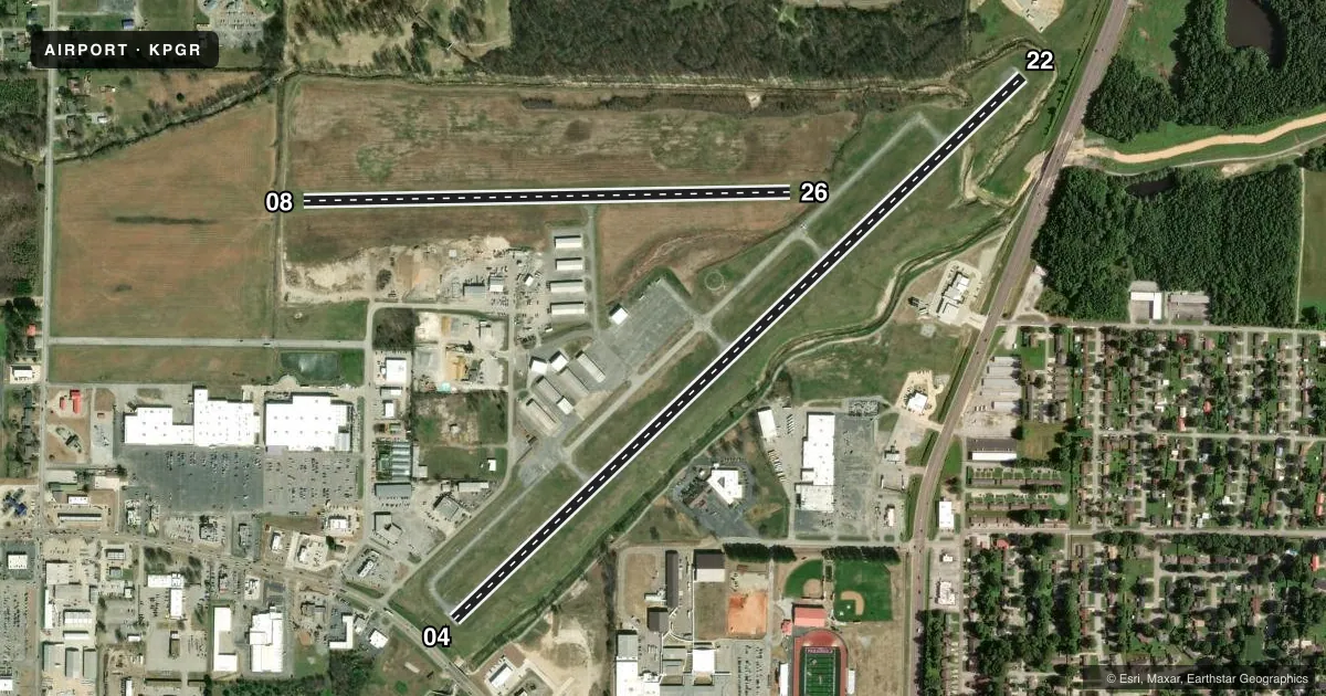
Runways & pattern
Full pagePattern entry · RWY 22
LEFT TRAFFIC| Runway | Heading (°M) | Length | Surface | Traffic |
|---|---|---|---|---|
| 04/22Favored | 45° / 225° | 4,500 ft | ASPH | Standard L |
| 08/26 | 88° / 268° | 2,792 ft | TURF | Standard L |
Runway end performance
| End | TORA | TODA | ASDA | LDA | VGSI | Approach lights | Obstruction |
|---|---|---|---|---|---|---|---|
| 04 | — | — | — | — | PAPI 2-box left(3°) | — | 28', road, 180' from thr, 0' R of cntrln, slope 0 |
| 22 | — | — | — | — | PAPI 2-box left(4°) | — | 13', road, 460' from thr, 200' R of cntrln, slope 20 |
| 08 | — | — | — | — | — | — | 40', pline, 1300' from thr, 50' R of cntrln, slope 32 |
| 26 | — | — | — | — | — | — | 40', trees, 1750' from thr, 0' R of cntrln, slope 43 |
Declared distances in feet. TORA = takeoff run available, TODA = takeoff distance, ASDA = accelerate-stop, LDA = landing distance.
Airport sketch
Runways drawn to scale from FAA survey coordinates, rendered over satellite imagery. Not for navigation.
Approaches & charts
Services on the field
Fuel grades, oxygen, maintenance, ramp storage and lighting — as declared to the FAA by the airport operator.
Fuel & services
- Fuel
- 100LLA
- Oxygen (bottled)
- Not available
- Oxygen (bulk)
- Not available
- Other services
- AMB,INSTR
Ramp & ground
- Transient storage
- Tie-down
- Landing fee
- No fee published
- Customs
- Not available
- Lighting schedule
- SEE RMK
- Beacon schedule
- SS-SR
- Beacon
- White / Green (civil land)(WG)
- Wind indicator
- Lighted
- Segmented circle
- Yes
Fuel & FBOs
Cheapest 100LL and Jet A on the field and nearby. Always confirm with the FBO before taxi.
Airport notes
Surface conditions, obstructions, local procedures, lighting outages and other notes published with each FAA cycle.
General notes
- UNLGTD TOWER 250 FT AGL .17 MILES ESE AER 04.
- WILDLIFE ON & INVOF OF RY AND TWY.
- FOR CD CTC MEMPHIS ARTCC AT 901-368-8453/8449.
Lighting notes
- ACTVT MIRL RY 04/22, REIL & PAPI RYS 04 & 22 - CTAF.
Fuel notes
- 100LL24 HR SELF SVC FUEL AVBL WITH CREDIT CARD (100LL & JET A)
Runway surface & condition
- 08/26SOFT WHEN WET.
Approach & departure obstructions
- 04ROAD 180 FT & EXTENDS INTO RY PROTECTION ZONE.
- 22OPEN DITCH 55 FT WIDE; 10 FT DEEP 138 FT FM THLD CROSSING.
- 04APCH RATIO 23:1 TO DSPLCD THLD.
- 22APCH SLOPE 46:1 TO DSPLD THLD.
Other notes
- THIS AIRPORT HAS BEEN SURVEYED BY THE NATIONAL GEODETIC SURVEY.
- 1FOR SVC AFT HRS CALL 870-450-7599 FEE CHARGED.
VFR map & nearby airports
VFR sectional. Tap any ICAO chip to open that airport.
Key facts · KPGR
Answer card- ICAO
- KPGR
- Name
- KIRK FLD
- Location
- PARAGOULD, ARKANSAS
- Elevation
- 290.2 ft MSL
- Traffic pattern altitude
- 1,099.2 ft MSL (809 AGL)
- Control tower
- Non-towered (use CTAF)
- Total runways
- 2
- Longest runway
- 04/22 · 4,500 ft
- Published ILS approaches
- 0
- Published frequencies
- 2
- Magnetic variation
- 1°
- Current flight rules
- VFR
- Current wind
- 240° at 7 kt
- Favored runway now
- RWY 22
Kirk Fld sits in Paragould, Arkansas. Field elevation is 290.2 ft MSL. The airport has two runways. The longest is 04/22 at 4,500 ft. Runway 08/26 is 2,792 ft of turf. There is no control tower. CTAF and UNICOM are both 122.8.
No ILS approaches are published here. Pattern altitude is 809 ft AGL, which is 1,099.2 ft MSL. The on-field FBO is Paragould Airport. It carries 100LL and Jet A Prist. For after-hours service, the published remarks say to call ahead. A fee is charged. Twenty-four hour self-serve fuel is also available with credit card for 100LL and Jet A.
A first-time pilot should pay attention to the published obstructions and runway notes. There is an unlighted tower east-southeast of the field. Runway 04 has a road in the runway protection zone. Runway 22 has an open ditch near the threshold. Runway 08/26 is soft when wet. Wildlife is also present on and near the runway and taxiway. Medium intensity runway lights are on 04/22. REILs and PAPI are on 04 and 22. They are controlled by CTAF. For clearance delivery, contact Memphis ARTCC. Check the current Chart Supplement before flight for any current operational notes.