METAR & TAF KMXA
KMXA does not publish a METAR.
Showing the nearest reporting station: KHKA (BLYTHEVILLE MUNI) · 16.0 NM away. Conditions at KMXA may differ.
METAR · KHKA
Observed 03:53Z
KHKA 250353Z AUTO 09003KT 10SM CLR 22/21 A3006 RMK AO2 SLP178 T02220206 PWINO $
- Wind
- 090° @ 3 kt
- Visibility
- 10 SM
- Temp / Dew
- 22°C / 21°C
- Altimeter
- 30.06 inHg
- Clouds
- CLR
- Density alt
- 967 ft
- Ceiling
- Unlimited
- Rules
- VFR
Airport info & contacts
Manager on record, flight service, ARTCC, attendance schedule and pattern altitude — published by the FAA and refreshed every 28 days.
Location
- From city
- 2 NM NE
- VFR sectional
- MEMPHIS
- ARTCC
- ZME · MEMPHIS
- NOTAM facility
- JBR (NOTAM-D)
Airport manager
- Name
- JOHN GEARHART
- Phone
- 479-757-0722
- Address
- PO BOX 895, MANILA AR 72442
Flight service · Hours
- FSS JBR
- JONESBORO1-800-WX-BRIEF
- Attendance
- MON-FRI · DALGT
Frequencies
Tap any row to copy the frequency to your clipboard.
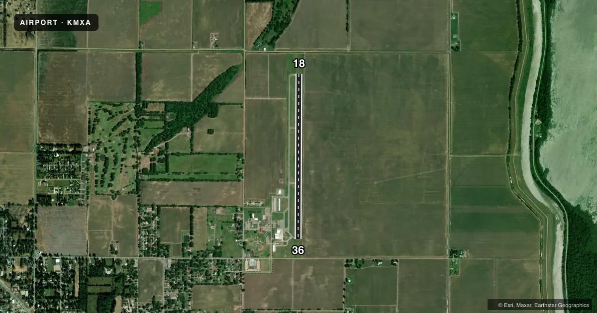
Runways & pattern
Full pagePattern entry · RWY 18
LEFT TRAFFICRunway end performance
| End | TORA | TODA | ASDA | LDA | VGSI | Approach lights | Obstruction |
|---|---|---|---|---|---|---|---|
| 18 | — | — | — | — | PAPI 2-box right(4°) | — | 75', tree, 2300' from thr, 0' R of cntrln, slope 28 |
| 36 | — | — | — | — | PAPI 2-box left(4°) | — | 14', road, 495' from thr, 0' R of cntrln, slope 21 |
Declared distances in feet. TORA = takeoff run available, TODA = takeoff distance, ASDA = accelerate-stop, LDA = landing distance.
Airport sketch
Runways drawn to scale from FAA survey coordinates, rendered over satellite imagery. Not for navigation.
Approaches & charts
Services on the field
Fuel grades, oxygen, maintenance, ramp storage and lighting — as declared to the FAA by the airport operator.
Fuel & services
- Fuel
- 100LLA
- Oxygen (bottled)
- Not available
- Oxygen (bulk)
- Not available
- Airframe repair
- Major
- Power plant repair
- Major
- Other services
- AGRI,INSTR
Ramp & ground
- Transient storage
- Tie-down
- Landing fee
- No fee published
- Customs
- Not available
- Lighting schedule
- SEE RMK
- Beacon schedule
- SS-SR
- Beacon
- White / Green (civil land)(WG)
- Wind indicator
- Lighted
- Segmented circle
- Yes
Fuel & FBOs
Cheapest 100LL and Jet A on the field and nearby. Always confirm with the FBO before taxi.
Airport notes
Surface conditions, obstructions, local procedures, lighting outages and other notes published with each FAA cycle.
General notes
- NUMEROUS AGRICULTURAL ACFT OPNS FM FEB-NOV 500 FT AGL & BLO.
- FOR CD CTC MEMPHIS ARTCC AT 901-368-8453/8449.
Lighting notes
- ACTVT REIL RWYS 18 & 36; MIRL RWY 18/36; AND PAPI RWYS 18 & 36 - CTAF. LOCAL ARPT WX 4 CLICKS
Fuel notes
- 100LLFOR SVC AFT HRS CALL 479-757-0722 NO FEE. FUEL AVBL WITH CREDIT CARD 24 HR.
Approach & departure obstructions
- 36APCH SLOPE 34:1 TO DSPLCD THLD.
Other notes
- 4 CLICKS FOR TEMP, WIND, AND DENSITY ALT.
VFR map & nearby airports
VFR sectional. Tap any ICAO chip to open that airport.
Key facts · KMXA
Answer card- ICAO
- KMXA
- Name
- MANILA MUNI
- Location
- MANILA, ARKANSAS
- Elevation
- 242.7 ft MSL
- Traffic pattern altitude
- 1,242.7 ft MSL (1,000 AGL)
- Control tower
- Non-towered (use CTAF)
- Total runways
- 1
- Longest runway
- 18/36 · 4,201 ft
- Published ILS approaches
- 0
- Published frequencies
- 2
- Magnetic variation
- 1°
- Current flight rules
- VFR
- Current wind
- 090° at 3 kt
- Favored runway now
- RWY 18
Manila Muni sits in Manila, Arkansas. The field elevation is 242.7 ft MSL. It has one runway, 18/36, which is 4,201 ft long and asphalt. There is no control tower. CTAF and UNICOM are both 122.8. No ILS approaches are published here.
The pattern altitude is not published. Use the standard 1,000 ft AGL unless the current Chart Supplement says otherwise. The airport has one on-field FBO, Manila Municipal Airport. It carries AVGAS 100LL. For fuel after hours, the published remarks give a phone number for service. Fuel is available by credit card from 8 a.m. to 5 p.m.
A few operational notes matter here. Runway end identifier lights, medium intensity runway lights and PAPI are all on runway 18/36. They are activated on CTAF. The remarks also note a 34 to 1 approach slope to the displaced threshold on runway 36. Clearance delivery is handled through Memphis ARTCC by phone. The field also sees numerous agricultural aircraft operations from February through November at 500 ft AGL and below. Expect that traffic picture when you plan your arrival.