METAR & TAF M12
M12 does not publish a METAR.
Showing the nearest reporting station: KHKA (BLYTHEVILLE MUNI) · 9.4 NM away. Conditions at M12 may differ.
METAR · KHKA
Observed 07:53Z
KHKA 270753Z AUTO 22004KT 10SM FEW060 28/26 A2988 RMK AO2 SLP115 T02780261 PWINO $
- Wind
- 220° @ 4 kt
- Visibility
- 10 SM
- Temp / Dew
- 28°C / 26°C
- Altimeter
- 29.88 inHg
- Clouds
- FEW
- Density alt
- 1,931 ft
- Ceiling
- Unlimited
- Rules
- VFR
Airport info & contacts
Manager on record, flight service, ARTCC, attendance schedule and pattern altitude — published by the FAA and refreshed every 28 days.
Location
- From city
- 2 NM NW
- VFR sectional
- ST LOUIS
- ARTCC
- ZME · MEMPHIS
- NOTAM facility
- STL (NOTAM-D)
Airport manager
- Name
- MIKE LEE
- Phone
- 573-695-3842
- Address
- 1051 ADMINISTRATION DRIVE, STEELE MO 63877
Flight service · Hours
- FSS STL
- SAINT LOUIS1-800-WX-BRIEF
- Attendance
- MON-FRI · 0700-1700
Frequencies
Tap any row to copy the frequency to your clipboard.
Runways & pattern
Full pagePattern entry · RWY 18
LEFT TRAFFICRunway end performance
| End | TORA | TODA | ASDA | LDA | VGSI | Approach lights | Obstruction |
|---|---|---|---|---|---|---|---|
| 36 | — | — | — | — | — | — | 15', road, 315' from thr, 150' R of cntrln, slope 7 |
Declared distances in feet. TORA = takeoff run available, TODA = takeoff distance, ASDA = accelerate-stop, LDA = landing distance.
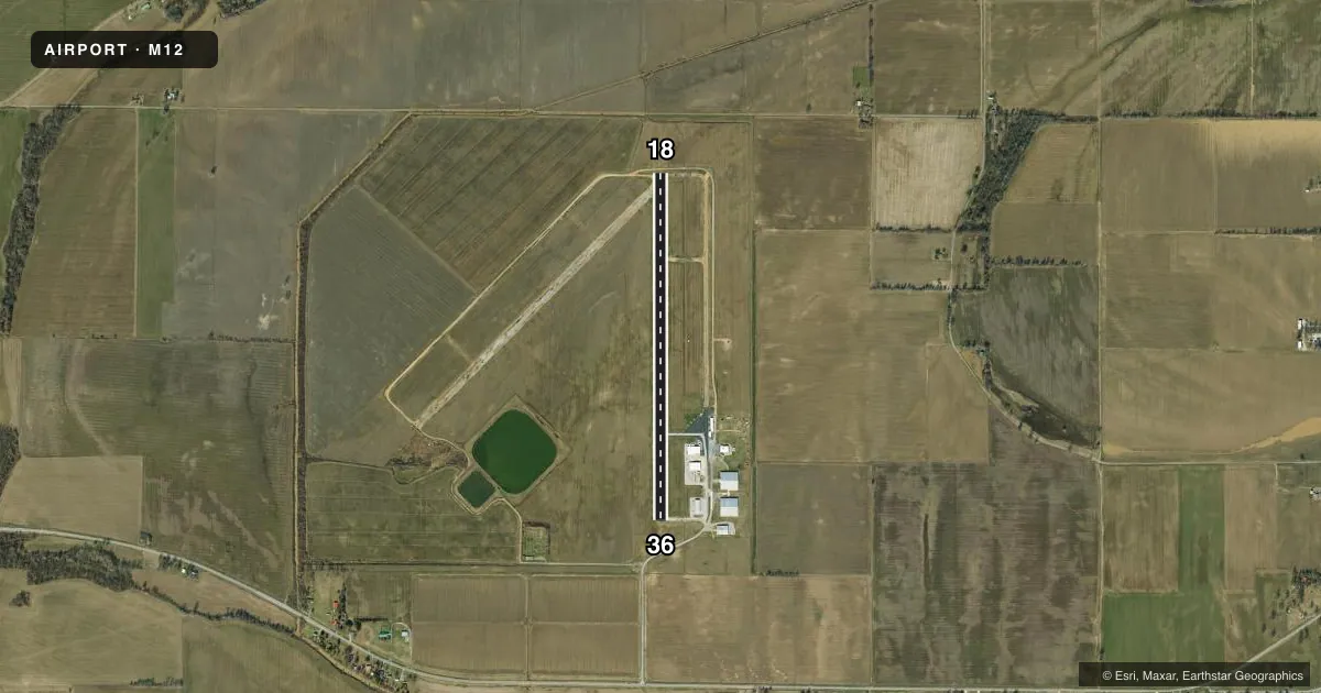
Airport sketch
Runways drawn to scale from FAA survey coordinates, rendered over satellite imagery. Not for navigation.
Approaches & charts
Services on the field
Fuel grades, oxygen, maintenance, ramp storage and lighting — as declared to the FAA by the airport operator.
Fuel & services
- Fuel
- Not available
- Other services
- AGRI
Ramp & ground
- Transient storage
- Tie-down
- Landing fee
- No fee published
- Customs
- Not available
- Lighting schedule
- SEE RMK
- Beacon schedule
- SS-SR
- Beacon
- White / Green (civil land)(WG)
- Wind indicator
- Yes
- Segmented circle
- Yes
Fuel & FBOs
Cheapest 100LL and Jet A on the field and nearby. Always confirm with the FBO before taxi.
Airport notes
Surface conditions, obstructions, local procedures, lighting outages and other notes published with each FAA cycle.
General notes
- CROP DUSTING ACFT ON & INVOF ARPT.
- PARL TWY CLSD AT NORTH END OF APRON
- TWY CONNECTORS CLSD NORTH OF MAIN APRON
- FOR CD CTC MEMPHIS ARTCC AT 901-368-8453/8449.
Lighting notes
- ACTVT MIRL RWY 18/36 - CTAF.
Other notes
- ESTABD PRIOR OCT 1959.
- NSTD SEG CIRCLE - NO SEGMENTATION; SMALL CIRCLE.
VFR map & nearby airports
VFR sectional. Tap any ICAO chip to open that airport.
Key facts · M12
Answer card- ICAO
- M12
- Name
- STEELE MUNI
- Location
- STEELE, MISSOURI
- Elevation
- 259.2 ft MSL
- Traffic pattern altitude
- 1,259.2 ft MSL (1,000 AGL)
- Control tower
- Non-towered (use CTAF)
- Total runways
- 1
- Longest runway
- 18/36 · 3,984 ft
- Published ILS approaches
- 0
- Published frequencies
- 2
- Magnetic variation
- 1°
- Current flight rules
- VFR
- Current wind
- 220° at 4 kt
- Favored runway now
- RWY 18
Steele Muni sits in Steele, Missouri. Field elevation is 259.2 ft MSL. The airport has one runway. Runway 18/36 is 3,984 ft of asphalt, so it is the longest and only landing surface on the field. There is no control tower. CTAF and UNICOM are both 122.8.
No ILS approaches are published here. Pattern altitude is not published, so use the standard 1,000 ft AGL for light piston operations unless the current Chart Supplement says otherwise. The published remarks matter here. Medium intensity runway lights on 18/36 are controlled from the CTAF. Crop dusting aircraft operate on and near the airport. Taxiway connectors are closed north of the main apron. The parallel taxiway is also closed at the north end of the apron. The segmented circle is nonstandard and small, so do not expect a textbook traffic pattern setup.
There are no on-field FBOs listed in the facts. Contact the airport operator directly before arrival if you need service details. For clearance delivery, Memphis ARTCC is the published contact. First-time visitors should plan for an uncontrolled field with ag traffic. Verify runway lighting use before a night arrival. Review the current Chart Supplement for any local procedures.