METAR & TAF 2M8
Current METAR
Observed 12:55Z
K2M8 271255Z AUTO VRB05KT 10SM CLR 27/24 A2998 RMK AO2 T02660238 $
- Wind
- VAR @ 5 kt
- Visibility
- 10 SM
- Temp / Dew
- 27°C / 24°C
- Altimeter
- 29.98 inHg
- Clouds
- CLR
- Density alt
- 1,672 ft
- Ceiling
- Unlimited
- Rules
- VFR
Airport info & contacts
Manager on record, flight service, ARTCC, attendance schedule and pattern altitude — published by the FAA and refreshed every 28 days.
Location
- From city
- 4 NM SW
- VFR sectional
- MEMPHIS
- ARTCC
- ZME · MEMPHIS
- NOTAM facility
- MKL (NOTAM-D)
Airport manager
- Name
- ZACH HAYS
- Phone
- 901-358-0028
- Address
- 2787 NORTH SECOND STREET, MEMPHIS TN 38127
Flight service · Hours
- FSS MKL
- JACKSON1-800-WX-BRIEF
- Attendance
- WED-SAT · 0700-1700
Frequencies
Tap any row to copy the frequency to your clipboard.
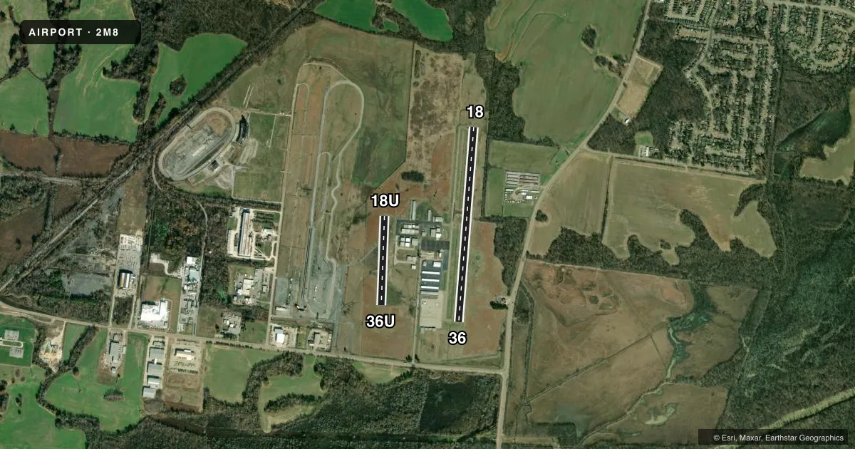
Runways & pattern
Full pagePattern entry · RWY 36U
LEFT TRAFFIC| Runway | Heading (°M) | Length | Surface | Traffic |
|---|---|---|---|---|
| 18/36Favored | 183° / 3° | 3,499 ft | ASPH | 36 R |
| 18U/36U | 181° / 1° | 1,600 ft | ASPH | Standard L |
Runway end performance
| End | TORA | TODA | ASDA | LDA | VGSI | Approach lights | Obstruction |
|---|---|---|---|---|---|---|---|
| 18 | — | — | — | — | PAPI 2-box left(4°) | — | 73', tree, 1408' from thr, 1406' R of cntrln, slope 16 |
| 36 | — | — | — | — | PAPI 2-box left(4°) | — | 55', tree, 981' from thr, 979' R of cntrln, slope 14 |
| 18U | — | — | — | — | — | — | 30', tree, 475' from thr, 87' R of cntrln, slope 9 |
| 36U | — | — | — | — | — | — | 96', trees, 1500' from thr, 217' R of cntrln, slope 13 |
Declared distances in feet. TORA = takeoff run available, TODA = takeoff distance, ASDA = accelerate-stop, LDA = landing distance.
Airport sketch
Runways drawn to scale from FAA survey coordinates, rendered over satellite imagery. Not for navigation.
Approaches & charts
Services on the field
Fuel grades, oxygen, maintenance, ramp storage and lighting — as declared to the FAA by the airport operator.
Fuel & services
- Fuel
- 100LLA+
Ramp & ground
- Transient storage
- Tie-down
- Landing fee
- No fee published
- Customs
- Not available
- Lighting schedule
- SS-SR
- Beacon schedule
- SS-SR
- Beacon
- White / Green (civil land)(WG)
- Wind indicator
- Lighted
- Segmented circle
- Yes
Fuel & FBOs
Cheapest 100LL and Jet A on the field and nearby. Always confirm with the FBO before taxi.
Airport notes
Surface conditions, obstructions, local procedures, lighting outages and other notes published with each FAA cycle.
General notes
- FIXED WING GRASS AREA TKOF OR LNDG NA.
- FOR CD CTC MEMPHIS APCH AT 901-842-8457.
Runway surface & condition
- 18U/36UCLSD INDEF.
Approach & departure obstructions
- 36UPLINE 970 FT FM RWY END; MKD WITH ORANGE BALLS.
Other notes
- VFR ONLY.
- 2UNATNDD THANKSGIVING & CHRISTMAS.
VFR map & nearby airports
VFR sectional. Tap any ICAO chip to open that airport.
Key facts · 2M8
Answer card- ICAO
- 2M8
- Name
- CHARLES W BAKER
- Location
- MILLINGTON, TENNESSEE
- Elevation
- 246.8 ft MSL
- Traffic pattern altitude
- 1,246.8 ft MSL (1,000 AGL)
- Control tower
- Non-towered (use CTAF)
- Total runways
- 2
- Longest runway
- 18/36 · 3,499 ft
- Published ILS approaches
- 0
- Published frequencies
- 6
- Magnetic variation
- 1°
- Current flight rules
- VFR
- Current wind
- 000° at 5 kt
- Favored runway now
- RWY 36
Charles W Baker Airport is in Millington, Tennessee. The field elevation is 246.8 ft MSL. It has two paved runways. The longest is 3,499 ft. Runway 18U/36U is listed at 1,600 ft, but it is closed indefinitely. A power line is marked with orange balls near the 36U end, so pay close attention if you are operating near that side of the airport.
The airport is unattended on Thanksgiving and Christmas. It is VFR only. No ILS approaches are published. The pattern altitude is not published, so use the standard 1,000 ft AGL pattern unless current local guidance says otherwise. For this field, that puts the light piston pattern near 1,247 ft MSL.
There is no control tower. CTAF and UNICOM are both 122.8. Memphis Approach handles departure and approach services. The published remarks say to contact Memphis Approach at 901-842-8457 for clearance delivery. The on-field FBO is Charles W. Baker Airport. It carries 100LL and Jet A. If you are planning a first visit, verify current airport status and any local operating notes with the airport operator or the FBO directly by phone before you go.