METAR & TAF KMAW
Current METAR
Observed 13:35Z
KMAW 271335Z AUTO 20007KT 10SM CLR 27/22 A2997 RMK AO1
- Wind
- 200° @ 7 kt
- Visibility
- 10 SM
- Temp / Dew
- 27°C / 22°C
- Altimeter
- 29.97 inHg
- Clouds
- CLR
- Density alt
- 1,744 ft
- Ceiling
- Unlimited
- Rules
- VFR
Airport info & contacts
Manager on record, flight service, ARTCC, attendance schedule and pattern altitude — published by the FAA and refreshed every 28 days.
Location
- From city
- 3 NM N
- VFR sectional
- ST LOUIS
- ARTCC
- ZME · MEMPHIS
- NOTAM facility
- STL (NOTAM-D)
Airport manager
- Name
- DAVID BLALOCK
- Phone
- 573-276-2279
- Address
- PO BOX 411, MALDEN MO 63863
Flight service · Hours
- FSS STL
- SAINT LOUIS1-800-WX-BRIEF
- Attendance
- MON-FRI · 0800-1700
Frequencies
Tap any row to copy the frequency to your clipboard.
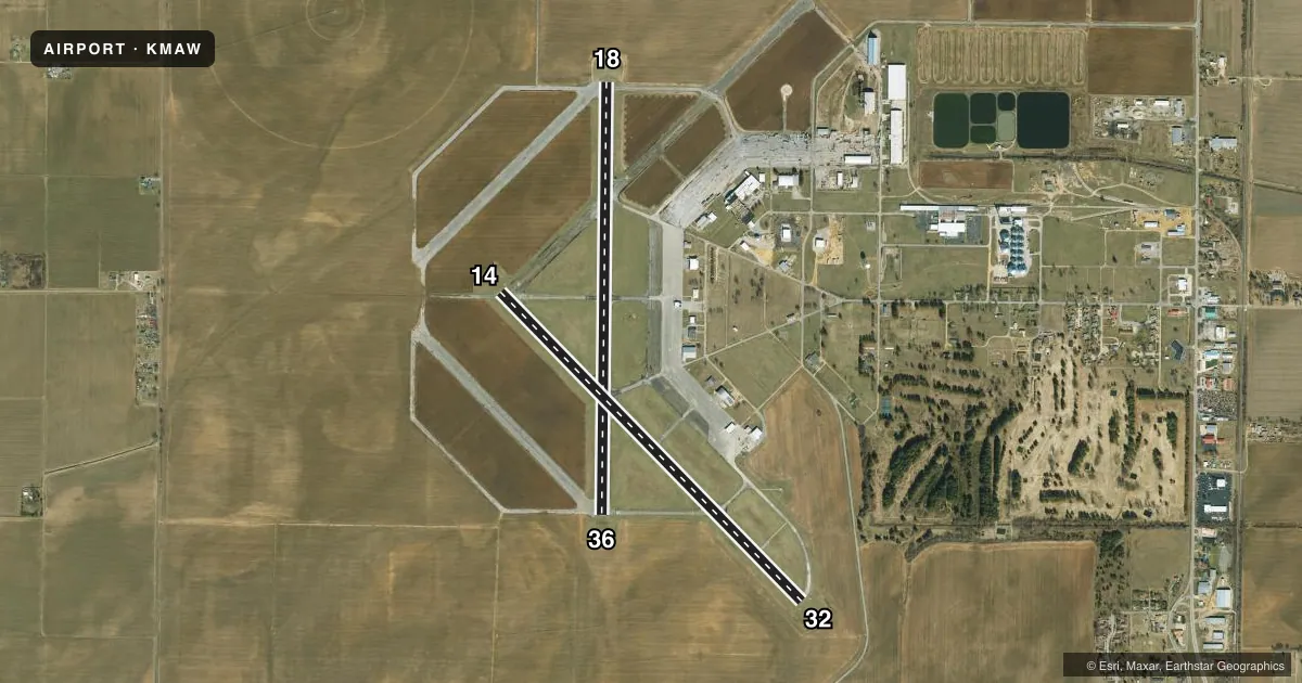
Runways & pattern
Full pagePattern entry · RWY 18
RIGHT TRAFFIC| Runway | Heading (°M) | Length | Surface | Traffic |
|---|---|---|---|---|
| 18/36Favored | 180° / 0° | 5,010 ft | ASPH | 18 R |
| 14/32 | 135° / 315° | 5,001 ft | ASPH | 14 R |
Runway end performance
| End | TORA | TODA | ASDA | LDA | VGSI | Approach lights | Obstruction |
|---|---|---|---|---|---|---|---|
| 18 | — | — | — | — | PAPI 4-box left(3°) | — | — |
| 36 | — | — | — | — | PAPI 4-box right(3°) | — | — |
| 32 | — | — | — | — | PAPI 4-box right(3°) | — | — |
Declared distances in feet. TORA = takeoff run available, TODA = takeoff distance, ASDA = accelerate-stop, LDA = landing distance.
Airport sketch
Runways drawn to scale from FAA survey coordinates, rendered over satellite imagery. Not for navigation.
Approaches & charts
Services on the field
Fuel grades, oxygen, maintenance, ramp storage and lighting — as declared to the FAA by the airport operator.
Fuel & services
- Fuel
- 100LLA1+
- Oxygen (bottled)
- Not available
- Oxygen (bulk)
- Not available
- Airframe repair
- Minor
- Power plant repair
- Minor
Ramp & ground
- Transient storage
- Tie-down
- Hangar
- Landing fee
- No fee published
- Customs
- Not available
- Lighting schedule
- SEE RMK
- Beacon schedule
- SS-SR
- Beacon
- White / Green (civil land)(WG)
- Wind indicator
- Lighted
- Segmented circle
- Yes
Fuel & FBOs
Cheapest 100LL and Jet A on the field and nearby. Always confirm with the FBO before taxi.
Airport notes
Surface conditions, obstructions, local procedures, lighting outages and other notes published with each FAA cycle.
General notes
- CROP DUSTING ACFT ON & INVOF ARPT.
- IRRIGATION SYSTEM MAY BE OPERATING WITHIN 300 FT OF RY 18 AND RY 32 ENDS AND SIDES.
- A/G TEST FLYING.
- 24 HR ACCESS TO PILOTS LOUNGE. ENTER UNICOM ON LOCK FOR ACCESS.
- GCO AVBL ON FREQ 135.075 4 CLICKS TO MEMPHIS CENTER AND 6 CLICKS TO FSS .
- PERM AEROBATIC PRACTICE BOX SFC - 5,000 FT, WEST OF RWYS.
- FOR CD IF UNA VIA GCO CTC MEMPHIS ARTCC AT 901-368-8453/8449.
Lighting notes
- ACTVT REIL RWY 14/32 & 18/36; PAPI RWY 18, 36 & 32; MIRL RWYS 14/32 & 18/36 - CTAF.
Fuel notes
- A1+REGULAR AND AFTER HOURS, CALL IN ADVANCE FOR JET A1 573-776-4406
Approach & departure obstructions
- 32REIL OTS INDEFINITELY.
Other notes
- MANAGERFBO PHONE (573)-776-4406 EMERGENCY CONTACT (573)-281-0059
VFR map & nearby airports
VFR sectional. Tap any ICAO chip to open that airport.
Key facts · KMAW
Answer card- ICAO
- KMAW
- Name
- MALDEN RGNL
- Location
- MALDEN, MISSOURI
- Elevation
- 295.3 ft MSL
- Traffic pattern altitude
- 1,295.3 ft MSL (1,000 AGL)
- Control tower
- Non-towered (use CTAF)
- Total runways
- 2
- Longest runway
- 18/36 · 5,010 ft
- Published ILS approaches
- 0
- Published frequencies
- 2
- Magnetic variation
- 1°
- Current flight rules
- VFR
- Current wind
- 200° at 7 kt
- Favored runway now
- RWY 18
Malden Rgnl is in Malden, Missouri. Field elevation is 295.3 ft MSL. The airport has two asphalt runways. The longest is runway 18/36 at 5,010 ft. There is no control tower. CTAF and UNICOM are both 122.8. No ILS approaches are published.
Pattern altitude is not published. Use the standard 1,000 ft AGL for light piston traffic unless the current FAA Chart Supplement says otherwise. First Flight is on the field. It carries 100LL and Jet A Prist. Call ahead if you need jet fuel after hours. Published remarks also note a permanent aerobatic practice box west of the runways. Air-to-ground test flying occurs. Crop dusting aircraft operate on and near the airport. An irrigation system may be active within 300 ft of the ends and sides of runways 18 and 32.
Runway lighting is pilot controlled through CTAF. REILs are installed on both runways. PAPI is published for runways 18, 36 and 32. REILs on runway 32 are out of service indefinitely. There is 24-hour access to the pilots lounge through the UNICOM lock. For a first arrival, plan for an active non-towered field with mixed local traffic. Check the current FAA Chart Supplement for any changes before you go.