METAR & TAF KPYN
KPYN does not publish a METAR.
Showing the nearest reporting station: KPOF (POPLAR BLUFF RGNL BUSINESS) · 28.2 NM away. Conditions at KPYN may differ.
METAR · KPOF
Observed 16:53Z
KPOF 271653Z AUTO 22011KT 10SM CLR 32/24 A2991 RMK AO2 SLP120 T03170244 $
- Wind
- 220° @ 11 kt
- Visibility
- 10 SM
- Temp / Dew
- 32°C / 24°C
- Altimeter
- 29.91 inHg
- Clouds
- CLR
- Density alt
- 2,631 ft
- Ceiling
- Unlimited
- Rules
- VFR
Airport info & contacts
Manager on record, flight service, ARTCC, attendance schedule and pattern altitude — published by the FAA and refreshed every 28 days.
Location
- From city
- 2 NM SW
- VFR sectional
- KANSAS CITY
- ARTCC
- ZME · MEMPHIS
- NOTAM facility
- STL (NOTAM-D)
Airport manager
- Name
- BILL MCMURRY
- Phone
- 573-223-4528
- Address
- 115 W GREEN ST BOX 25, PIEDMONT MO 63957
Flight service · Hours
- FSS STL
- SAINT LOUIS1-800-WX-BRIEF
- Attendance
- Unattended
Frequencies
Tap any row to copy the frequency to your clipboard.
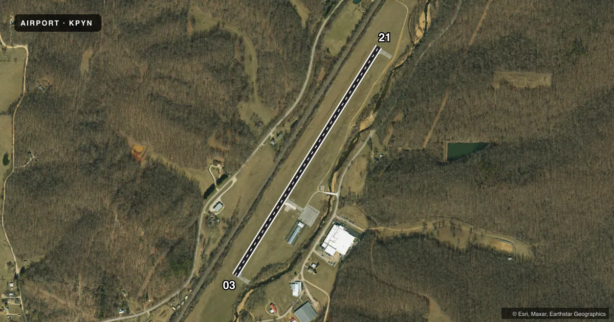
Runways & pattern
Full pagePattern entry · RWY 21
LEFT TRAFFICRunway end performance
| End | TORA | TODA | ASDA | LDA | VGSI | Approach lights | Obstruction |
|---|---|---|---|---|---|---|---|
| 03 | — | — | — | — | — | — | 102', trees, 1360' from thr, 250' R of cntrln, slope 11 |
| 21 | — | — | — | — | — | — | 38', trees, 830' from thr, 12' R of cntrln, slope 16 |
Declared distances in feet. TORA = takeoff run available, TODA = takeoff distance, ASDA = accelerate-stop, LDA = landing distance.
Airport sketch
Runways drawn to scale from FAA survey coordinates, rendered over satellite imagery. Not for navigation.
Approaches & charts
Services on the field
Fuel grades, oxygen, maintenance, ramp storage and lighting — as declared to the FAA by the airport operator.
Fuel & services
- Fuel
- 100LL
- Oxygen (bottled)
- Not available
- Oxygen (bulk)
- Not available
Ramp & ground
- Transient storage
- Tie-down
- Landing fee
- No fee published
- Customs
- Not available
- Lighting schedule
- SEE RMK
- Beacon schedule
- SS-SR
- Beacon
- White / Green (civil land)(WG)
- Wind indicator
- Lighted
- Segmented circle
- No
Fuel & FBOs
Cheapest 100LL and Jet A on the field and nearby. Always confirm with the FBO before taxi.
Airport notes
Surface conditions, obstructions, local procedures, lighting outages and other notes published with each FAA cycle.
General notes
- LAST 35 FT OF TURNAROUND AT SE TWY NOT USBL; PILOTS OF LOW WING ACFT USE CARE.
- BIRDS & WILDLIFE ON & INVOF ARPT.
- FOR CD CTC MEMPHIS ARTCC AT 901-368-8453/8449.
Lighting notes
- MIRL RY 03/21 PRESET ON MED INTST & REIL RYS 03 & 21 OPER DUSK-0200; TO INCR INTST MIRL RY 03/21 ACTVT - CTAF. AFT 0200 ACTVT MIRL RY 03/21 & REIL RYS 03 & 21 - CTAF.
Other notes
- NOT MONITORED.
VFR map & nearby airports
VFR sectional. Tap any ICAO chip to open that airport.
Key facts · KPYN
Answer card- ICAO
- KPYN
- Name
- PIEDMONT MUNI
- Location
- PIEDMONT, MISSOURI
- Elevation
- 466.4 ft MSL
- Traffic pattern altitude
- 1,466.4 ft MSL (1,000 AGL)
- Control tower
- Non-towered (use CTAF)
- Total runways
- 1
- Longest runway
- 03/21 · 3,296 ft
- Published ILS approaches
- 0
- Published frequencies
- 2
- Magnetic variation
- 2°
- Current flight rules
- VFR
- Current wind
- 220° at 11 kt
- Favored runway now
- RWY 21
Piedmont Muni is in Piedmont, Missouri. The field elevation is 466.4 ft MSL. It has one runway. Runway 03/21 is 3,296 ft long with asphalt pavement. There is no control tower. CTAF and UNICOM are both 122.8, though the UNICOM frequency is not monitored.
No ILS approaches are published here. Pattern altitude is not published, so use the standard 1,000 ft AGL for light piston traffic unless current local guidance says otherwise. The on-field FBO is Piedmont Municipal Airport. It carries AVGAS 100LL. Call (573) 223-4528 before arrival if you need current field details.
A few operational points matter here. The last 35 ft of the turnaround at the southeast taxiway is not usable, so low-wing pilots should watch their wing clearance. Runway lights on 03/21 are preset medium intensity. The runway end identifier lights on 03 and 21 operate from dusk to 0200. After 0200, activate the runway lights and REILs on CTAF if you need them. Birds and wildlife are reported on and near the airport, so keep a sharp scan on taxi and final. For clearance delivery, contact Memphis ARTCC directly.