METAR & TAF MO5
MO5 does not publish a METAR.
Showing the nearest reporting station: KPOF (POPLAR BLUFF RGNL BUSINESS) · 35.7 NM away. Conditions at MO5 may differ.
METAR · KPOF
Observed 14:53Z
KPOF 271453Z AUTO 22007KT 10SM CLR 29/23 A2993 RMK AO2 SLP129 T02890233 58017 $
- Wind
- 220° @ 7 kt
- Visibility
- 10 SM
- Temp / Dew
- 29°C / 23°C
- Altimeter
- 29.93 inHg
- Clouds
- CLR
- Density alt
- 2,476 ft
- Ceiling
- Unlimited
- Rules
- VFR
Airport info & contacts
Manager on record, flight service, ARTCC, attendance schedule and pattern altitude — published by the FAA and refreshed every 28 days.
Location
- From city
- 1 NM N
- VFR sectional
- KANSAS CITY
- ARTCC
- ZME · MEMPHIS
- NOTAM facility
- STL (NOTAM-D)
Airport manager
- Name
- RON KEENEY
- Phone
- 573-323-4335
- Address
- PO BOX 40, VAN BUREN MO 63965
Flight service · Hours
- FSS STL
- SAINT LOUIS1-800-WX-BRIEF
- Attendance
- Unattended
Frequencies
Tap any row to copy the frequency to your clipboard.
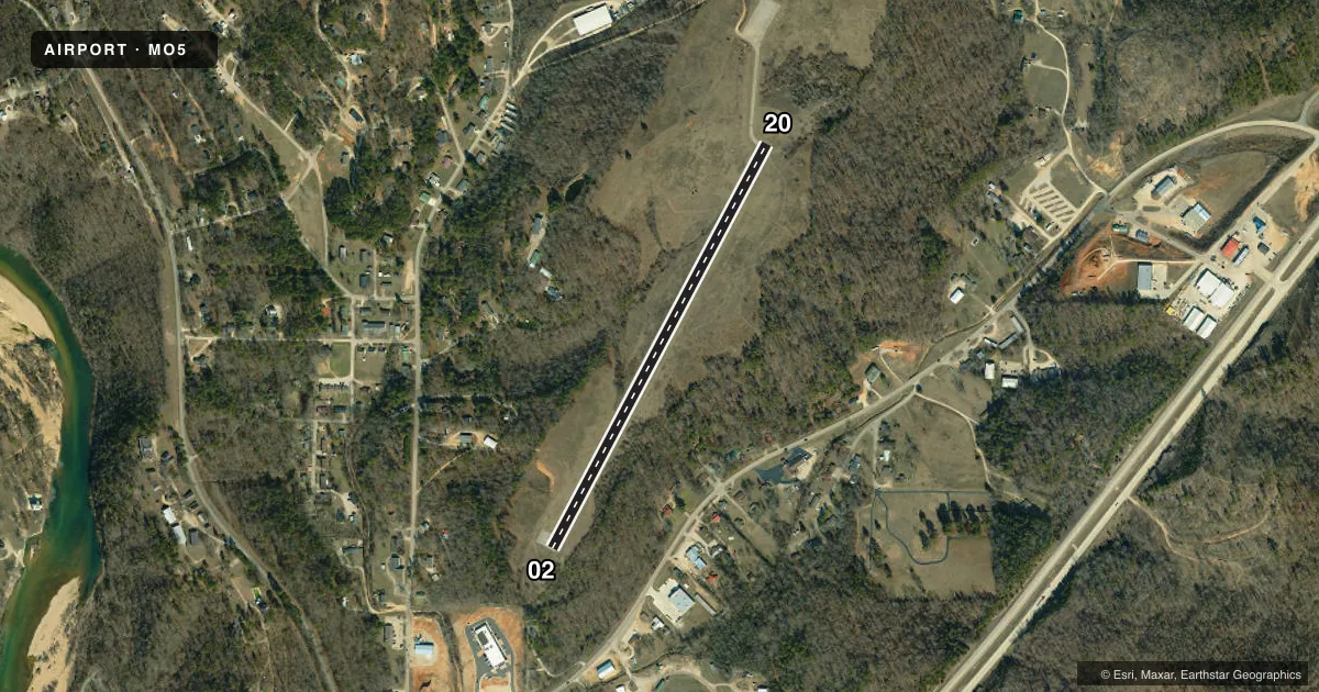
Runways & pattern
Full pagePattern entry · RWY 20
LEFT TRAFFICRunway end performance
| End | TORA | TODA | ASDA | LDA | VGSI | Approach lights | Obstruction |
|---|---|---|---|---|---|---|---|
| 02 | — | — | — | — | — | — | 13', brush, 278' from thr, 70' R of cntrln, slope 6 |
| 20 | — | — | — | — | — | — | 89', trees, 1480' from thr, 250' R of cntrln, slope 14 |
Declared distances in feet. TORA = takeoff run available, TODA = takeoff distance, ASDA = accelerate-stop, LDA = landing distance.
Airport sketch
Runways drawn to scale from FAA survey coordinates, rendered over satellite imagery. Not for navigation.
Approaches & charts
Services on the field
Fuel grades, oxygen, maintenance, ramp storage and lighting — as declared to the FAA by the airport operator.
Fuel & services
- Fuel
- Not available
Ramp & ground
- Transient storage
- Tie-down
- Landing fee
- No fee published
- Beacon schedule
- SEE RMK
- Wind indicator
- No
- Segmented circle
- Yes
Fuel & FBOs
Cheapest 100LL and Jet A on the field and nearby. Always confirm with the FBO before taxi.
Airport notes
Surface conditions, obstructions, local procedures, lighting outages and other notes published with each FAA cycle.
General notes
- DEER & WILDLIFE ON & INVOF ARPT.
- NTSD RWY SAFETY AREA ALG SIDES OF RWY AND BYD RWY 20 END. LRG DROP-OFFS, INCOR TRRN GRADS, BRUSH & TREES.
- FOR CD CTC MEMPHIS ARTCC AT 901-368-8453/8449.
Lighting notes
- BEACON OTS INDEFLY.
Approach & departure obstructions
- 02RWY 02 1-17 FT BRUSH & TREES, TALL WEEDS & HIGH GND, 0-200 FT FM RWY END, L&R.
- 20RWY 20 +1-33 FT BRUSH & TREES 0-75 FT FM RWY END, 100-120 FT L.
- 02RWY 02 MKGS SVRLY FADED.
- 20RWY 20 MKGS SVRLY FADED.
Other notes
- POOR CONDITION
- MANAGERPUBLIC WORKS DIRECTOR.
VFR map & nearby airports
VFR sectional. Tap any ICAO chip to open that airport.
Key facts · MO5
Answer card- ICAO
- MO5
- Name
- BOLLINGER-CRASS MEML
- Location
- VAN BUREN, MISSOURI
- Elevation
- 652 ft MSL
- Traffic pattern altitude
- 1,652 ft MSL (1,000 AGL)
- Control tower
- Non-towered (use CTAF)
- Total runways
- 1
- Longest runway
- 02/20 · 2,600 ft
- Published ILS approaches
- 0
- Published frequencies
- 1
- Magnetic variation
- 3°
- Current flight rules
- VFR
- Current wind
- 220° at 7 kt
- Favored runway now
- RWY 20
Bollinger-Crass Meml (MO5) sits in Van Buren, Missouri. The field elevation is 652 ft MSL. It has one runway, 02/20, which is 2,600 ft long and asphalt. This is an unattended field with no control tower. CTAF is 122.9.
No ILS approaches are published here. Pattern altitude is not published, so verify the current traffic pattern in the FAA Chart Supplement before you go. The published remarks matter here. Runway 02 has brush, trees, tall weeds and rising ground near the departure end. Runway 20 also has brush and trees close to the end. The runway safety area is not standard along the sides of the runway and beyond the Runway 20 end. There are drop-offs, terrain changes, brush and trees in the area. Deer and other wildlife are also reported on and near the airport.
The segmented circle and wind cone are in poor condition. Runway markings on both ends are severely faded. The beacon is reported to be on continuously. No on-field FBOs are listed, so plan on self-sufficiency and verify services with the airport operator before arrival. For clearance delivery, the published contact is Memphis ARTCC. This is a small field in a rural area. A careful look at the runway environment and a current briefing are smart before you launch.