METAR & TAF KMNF
KMNF does not publish a METAR.
Showing the nearest reporting station: KUNO (WEST PLAINS RGNL) · 11.3 NM away. Conditions at KMNF may differ.
METAR · KUNO
Observed 19:53Z
KUNO 271953Z AUTO 24007KT 10SM 34/23 A2989 RMK AO2 SLP105 T03390233
- Wind
- 240° @ 7 kt
- Visibility
- 10 SM
- Temp / Dew
- 34°C / 23°C
- Altimeter
- 29.89 inHg
- Clouds
- Clear
- Density alt
- 3,783 ft
- Ceiling
- Unlimited
- Rules
- VFR
Airport info & contacts
Manager on record, flight service, ARTCC, attendance schedule and pattern altitude — published by the FAA and refreshed every 28 days.
Location
- From city
- 1 NM SW
- VFR sectional
- KANSAS CITY
- ARTCC
- ZKC · KANSAS CITY
- NOTAM facility
- COU (NOTAM-D)
Airport manager
- Name
- WAYLON SCUDDER
- Phone
- 870-316-2241
- Address
- BOX 1090, MOUNTAIN VIEW MO 65548
Flight service · Hours
- FSS COU
- COLUMBIA1-800-WX-BRIEF
- Attendance
- 0800-1700
Frequencies
Tap any row to copy the frequency to your clipboard.
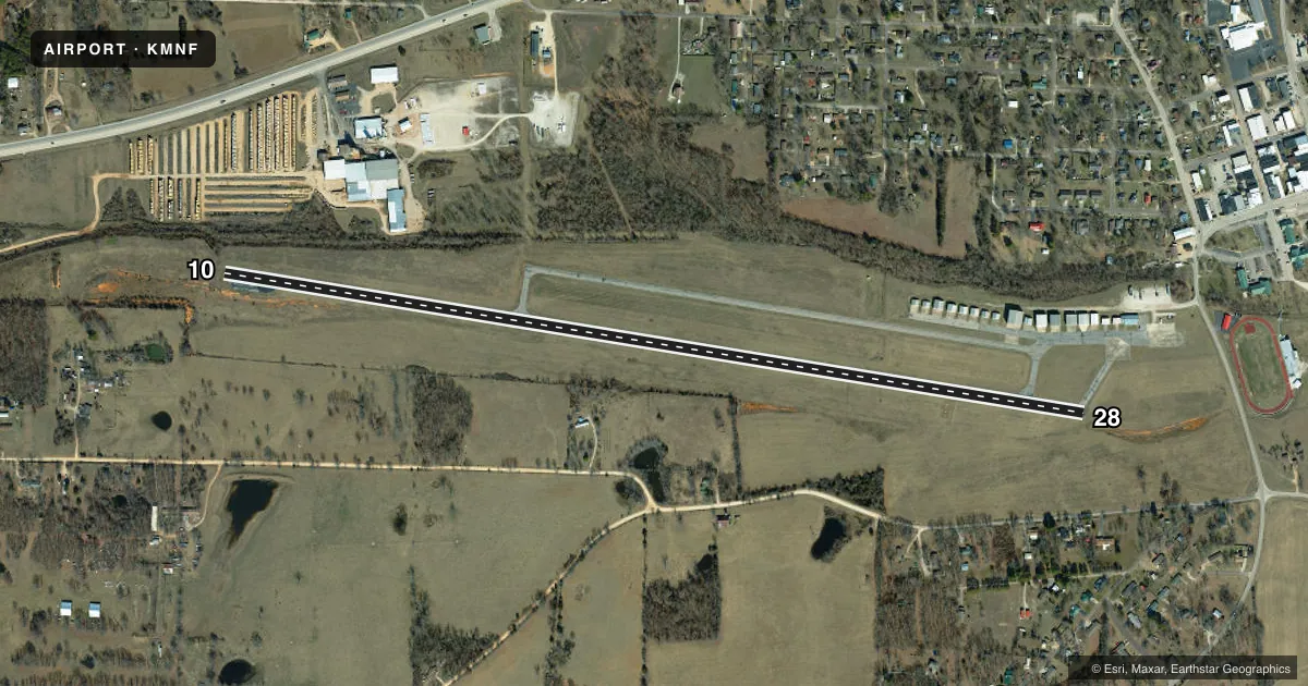
Runways & pattern
Full pagePattern entry · RWY 28
LEFT TRAFFICRunway end performance
| End | TORA | TODA | ASDA | LDA | VGSI | Approach lights | Obstruction |
|---|---|---|---|---|---|---|---|
| 10 | — | — | — | — | — | — | 37', pline, 600' from thr, 197' R of cntrln, slope 10 |
| 28 | — | — | — | — | PAPI 4-box left(3.5°) | — | 45', pole, 980' from thr, 250' R of cntrln, slope 17 |
Declared distances in feet. TORA = takeoff run available, TODA = takeoff distance, ASDA = accelerate-stop, LDA = landing distance.
Airport sketch
Runways drawn to scale from FAA survey coordinates, rendered over satellite imagery. Not for navigation.
Approaches & charts
Services on the field
Fuel grades, oxygen, maintenance, ramp storage and lighting — as declared to the FAA by the airport operator.
Fuel & services
- Fuel
- 100LL
- Oxygen (bottled)
- Not available
- Oxygen (bulk)
- Not available
- Airframe repair
- Not available
- Power plant repair
- Not available
Ramp & ground
- Transient storage
- Tie-down
- Landing fee
- No fee published
- Customs
- Not available
- Lighting schedule
- SEE RMK
- Beacon schedule
- SS-SR
- Beacon
- White / Green (civil land)(WG)
- Wind indicator
- Lighted
- Segmented circle
- Yes
Fuel & FBOs
Cheapest 100LL and Jet A on the field and nearby. Always confirm with the FBO before taxi.
Airport notes
Surface conditions, obstructions, local procedures, lighting outages and other notes published with each FAA cycle.
General notes
- WILDLIFE ON & INVOF ARPT.
- FOR CD CTC KANSAS CITY ARTCC AT 913-254-8508.
Lighting notes
- ACTVT MIRL RY 10/28 AND PAPI RY 28 - 122.8
Fuel notes
- 100LL100LL AVLBL 24 HRS SELF SERVICE
Approach & departure obstructions
- 108-12 FT SMALL TREES AND BRUSH 0-200 FT FROM RWY END 110 FT RIGHT AND 130 FT LEFT
- 10MARKINGS FADED
- 28MARKINGS FADED
- 28PAPI UNUSBL BYD 4 DEG LEFT OF CNTRLN.
Other notes
- 1AFT HRS PHONE NBRS POSTED ON TERMINAL DOOR.
- MANAGER870-316-2241 (MOBILE) AFTER HOURS
VFR map & nearby airports
VFR sectional. Tap any ICAO chip to open that airport.
Key facts · KMNF
Answer card- ICAO
- KMNF
- Name
- MOUNTAIN VIEW
- Location
- MOUNTAIN VIEW, MISSOURI
- Elevation
- 1,182 ft MSL
- Traffic pattern altitude
- 2,182 ft MSL (1,000 AGL)
- Control tower
- Non-towered (use CTAF)
- Total runways
- 1
- Longest runway
- 10/28 · 5,005 ft
- Published ILS approaches
- 0
- Published frequencies
- 2
- Magnetic variation
- 0°
- Current flight rules
- VFR
- Current wind
- 240° at 7 kt
- Favored runway now
- RWY 28
Mountain View Airport sits in Mountain View, Missouri. The field elevation is 1,182 ft MSL. It has one runway, 10/28, at 5,005 ft asphalt. This is an uncontrolled field. CTAF and UNICOM are both 122.8. No ILS approaches are published here. Pattern altitude is not published. Use the standard 1,000 ft AGL pattern unless current local guidance says otherwise.
The on-field FBO is Mountain View Airport. It carries 100LL. 24-hour self-serve fuel is published. The runway lighting is MIRL on 10/28. PAPI is available on runway 28 and is tied to 122.8. A few remarks matter for planning. Runway 10 and runway 28 both have faded markings. Trees and brush sit near the runway 10 end. Wildlife is reported on and near the airport. The PAPI on 28 is unusable more than 4 degrees left of centerline. For clearance delivery, Kansas City ARTCC is listed in the remarks. If you need after-hours help, the airport manager number is posted on the terminal door.