METAR & TAF KTVB
KTVB does not publish a METAR.
Showing the nearest reporting station: KUNO (WEST PLAINS RGNL) · 17.6 NM away. Conditions at KTVB may differ.
METAR · KUNO
Observed 20:53Z
KUNO 272053Z AUTO VRB04KT 10SM 34/23 A2989 RMK AO2 SLP105 T03390233 56021
- Wind
- VAR @ 4 kt
- Visibility
- 10 SM
- Temp / Dew
- 34°C / 23°C
- Altimeter
- 29.89 inHg
- Clouds
- Clear
- Density alt
- 3,830 ft
- Ceiling
- Unlimited
- Rules
- VFR
Airport info & contacts
Manager on record, flight service, ARTCC, attendance schedule and pattern altitude — published by the FAA and refreshed every 28 days.
Location
- From city
- 1 NM NE
- VFR sectional
- KANSAS CITY
- ARTCC
- ZKC · KANSAS CITY
- NOTAM facility
- COU (NOTAM-D)
Airport manager
- Name
- RON SCHEETS
- Phone
- 417-962-3136
- Address
- BOX 710, 618 MAIN ST, CABOOL MO 65689
Flight service · Hours
- FSS COU
- COLUMBIA1-800-WX-BRIEF
- Attendance
- Unattended
Frequencies
Tap any row to copy the frequency to your clipboard.
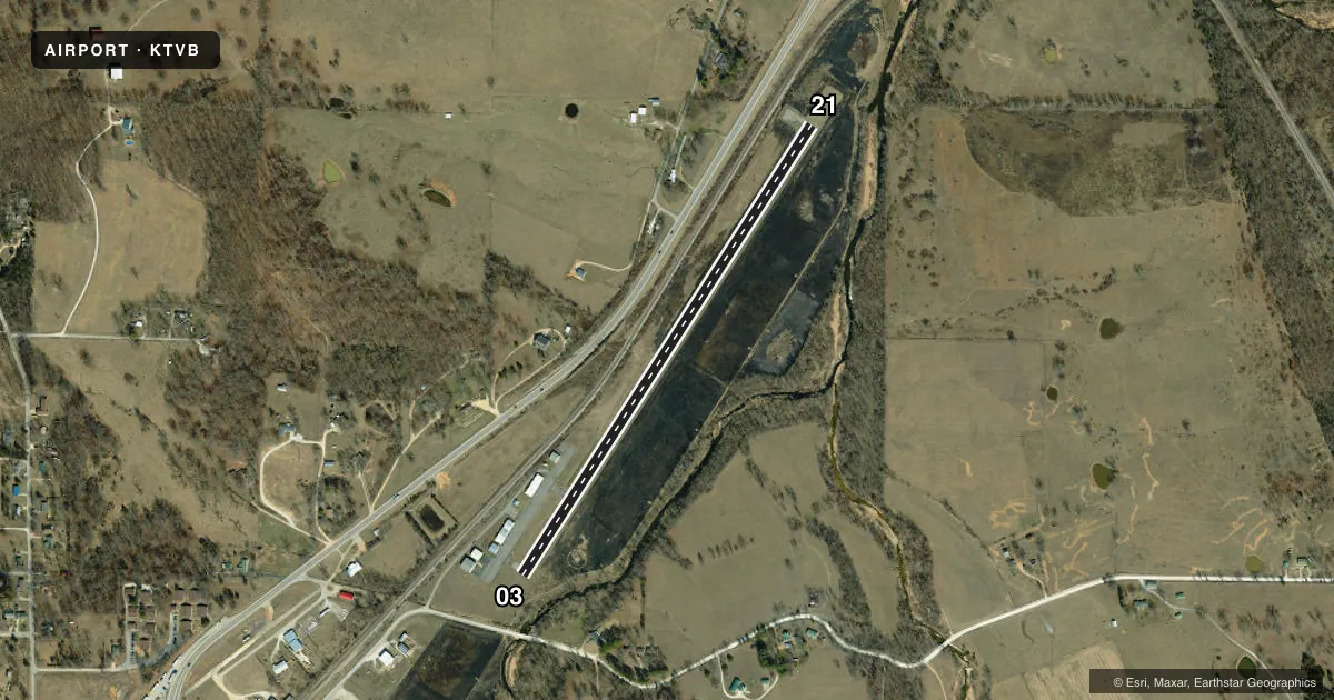
Runways & pattern
Full pagePattern entry · RWY 03
RIGHT TRAFFICRunway end performance
| End | TORA | TODA | ASDA | LDA | VGSI | Approach lights | Obstruction |
|---|---|---|---|---|---|---|---|
| 03 | — | — | — | — | — | — | 15', road, 300' from thr, 250' R of cntrln, slope 6 |
| 21 | — | — | — | — | — | — | 30', trees, 215' from thr, 210' R of cntrln, slope 0 |
Declared distances in feet. TORA = takeoff run available, TODA = takeoff distance, ASDA = accelerate-stop, LDA = landing distance.
Airport sketch
Runways drawn to scale from FAA survey coordinates, rendered over satellite imagery. Not for navigation.
Approaches & charts
Services on the field
Fuel grades, oxygen, maintenance, ramp storage and lighting — as declared to the FAA by the airport operator.
Fuel & services
- Fuel
- Not available
- Oxygen (bottled)
- Not available
- Oxygen (bulk)
- Not available
- Other services
- SALES
Ramp & ground
- Transient storage
- Tie-down
- Landing fee
- No fee published
- Customs
- Not available
- Lighting schedule
- SEE RMK
- Beacon schedule
- SS-SR
- Beacon
- White / Green (civil land)(WG)
- Wind indicator
- Yes
- Segmented circle
- No
Fuel & FBOs
Cheapest 100LL and Jet A on the field and nearby. Always confirm with the FBO before taxi.
Airport notes
Surface conditions, obstructions, local procedures, lighting outages and other notes published with each FAA cycle.
General notes
- BIRDS INVOF RY.
- ULTRALIGHT ACTIVTY ON & INVOF ARPT.
- BCN LOCATED .9 OF MI W/NW OF ARPT ON TOP OF WATER TWR.
- FOR CD CTC KANSAS CITY ARTCC AT 913-254-8508.
Lighting notes
- DUSK-DAWN. ACTVT MIRL RY 03/21 - CTAF.
Approach & departure obstructions
- 03RY 03 +1-27 FT BRUSH & TREES, 120-200 FT FM RY END, 115-150 FT R; +35 FT TREES, 180-200 FT FM RY END 150-250 FT R.
- 21RWY 21 +28 FT TREES 120 FT FM RY END 200-250 FT L; +1-32 FT BRUSH & RR 0-200 FT FM RY END 200-250 FT R.
Other notes
- EXISTED PRIOR TO 1959.
VFR map & nearby airports
VFR sectional. Tap any ICAO chip to open that airport.
Key facts · KTVB
Answer card- ICAO
- KTVB
- Name
- CABOOL MEML
- Location
- CABOOL, MISSOURI
- Elevation
- 1,220.1 ft MSL
- Traffic pattern altitude
- 2,220.1 ft MSL (1,000 AGL)
- Control tower
- Non-towered (use CTAF)
- Total runways
- 1
- Longest runway
- 03/21 · 3,002 ft
- Published ILS approaches
- 0
- Published frequencies
- 1
- Magnetic variation
- 3°
- Current flight rules
- VFR
- Current wind
- 000° at 4 kt
- Favored runway now
- RWY 03
Cabool Meml Airport is in Cabool, Missouri. The field elevation is 1,220.1 ft MSL. It has one runway, 03/21, which is 3,002 ft of asphalt. There is no control tower. CTAF is 122.9. No ILS approaches are published here.
Pattern altitude is not published. Use the standard 1,000 ft AGL pattern unless local procedures or current airport information say otherwise. Medium intensity runway lights on 03/21 are active from dusk to dawn. They are controlled by the CTAF. The airport has no on-field FBOs listed, so verify services with the airport operator or by calling the field before arrival.
This is a small non-towered field with published obstruction notes near both runway ends. Runway 03 has brush and trees near the departure end on the right side. Runway 21 has trees near the departure end on the left side. Brush and a railroad are also noted near the 21 end on the right side. Birds are reported in the vicinity of the runway. Ultralight activity also occurs on and near the airport. For clearance delivery, contact Kansas City ARTCC at 913-254-8508. The beacon is on a water tower west-northwest of the airport. Pilots should review the current FAA Chart Supplement before flying in.