METAR & TAF M48
M48 does not publish a METAR.
Showing the nearest reporting station: KTBN (WAYNESVILLE-ST ROBERT RGNL FORNEY FLD) · 26.0 NM away. Conditions at M48 may differ.
METAR · KTBN
Observed 19:55Z
KTBN 271955Z AUTO 21010G18KT 10SM FEW230 36/23 A2983 RMK AO2 SLP088 T03610226 $
- Wind
- 210° @ 10G18 kt
- Visibility
- 10 SM
- Temp / Dew
- 36°C / 23°C
- Altimeter
- 29.83 inHg
- Clouds
- FEW
- Density alt
- 4,114 ft
- Ceiling
- Unlimited
- Rules
- VFR
Airport info & contacts
Manager on record, flight service, ARTCC, attendance schedule and pattern altitude — published by the FAA and refreshed every 28 days.
Location
- From city
- 1 NM NW
- VFR sectional
- KANSAS CITY
- ARTCC
- ZKC · KANSAS CITY
- NOTAM facility
- COU (NOTAM-D)
Airport manager
- Name
- CITY OF HOUSTON
- Phone
- 417-967-3348
- Address
- 601 S. GRAND AVE., HOUSTON MO 65483
Flight service · Hours
- FSS COU
- COLUMBIA1-800-WX-BRIEF
- Attendance
- IREG
Frequencies
Tap any row to copy the frequency to your clipboard.
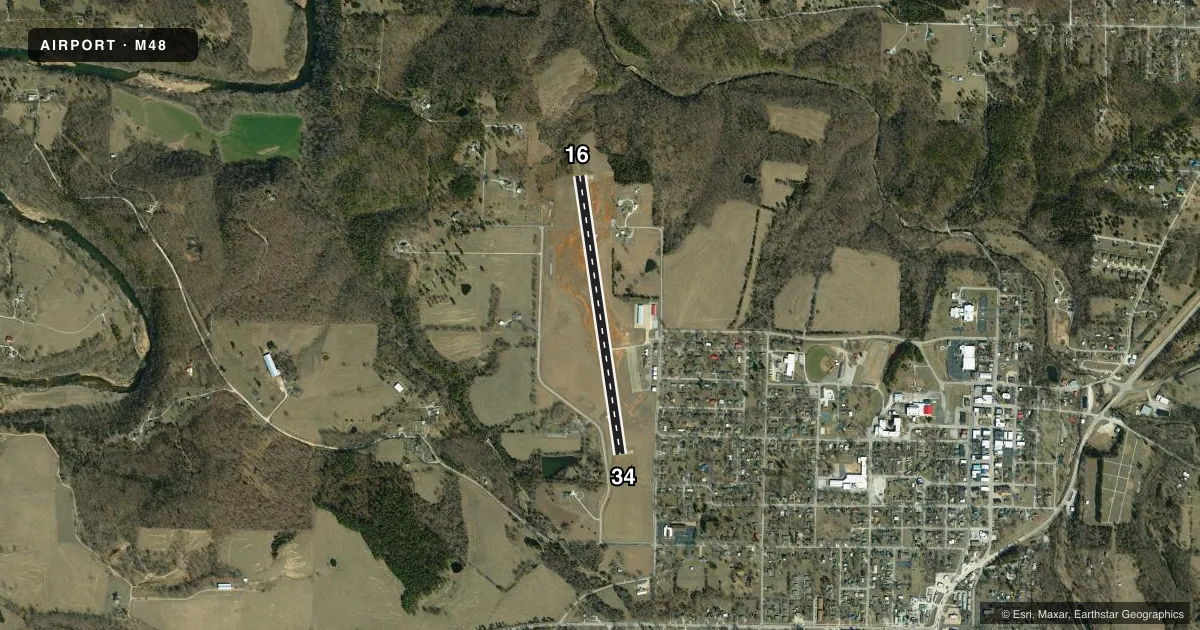
Runways & pattern
Full pagePattern entry · RWY 16
LEFT TRAFFICRunway end performance
| End | TORA | TODA | ASDA | LDA | VGSI | Approach lights | Obstruction |
|---|---|---|---|---|---|---|---|
| 16 | — | — | — | — | PAPI 2-box left(4°) | — | — |
| 34 | — | — | — | — | PAPI 2-box left(4°) | — | 57', tree, 1250' from thr, 195' R of cntrln, slope 18 |
Declared distances in feet. TORA = takeoff run available, TODA = takeoff distance, ASDA = accelerate-stop, LDA = landing distance.
Airport sketch
Runways drawn to scale from FAA survey coordinates, rendered over satellite imagery. Not for navigation.
Approaches & charts
Services on the field
Fuel grades, oxygen, maintenance, ramp storage and lighting — as declared to the FAA by the airport operator.
Fuel & services
- Fuel
- 100LL
- Oxygen (bottled)
- Not available
- Oxygen (bulk)
- Not available
- Airframe repair
- Not available
- Power plant repair
- Not available
- Other services
- AGRI
Ramp & ground
- Transient storage
- Tie-down
- Hangar
- Landing fee
- No fee published
- Customs
- Not available
- Lighting schedule
- SEE RMK
- Beacon schedule
- SS-SR
- Beacon
- White / Green (civil land)(WG)
- Wind indicator
- Lighted
- Segmented circle
- Yes
Fuel & FBOs
Cheapest 100LL and Jet A on the field and nearby. Always confirm with the FBO before taxi.
Airport notes
Surface conditions, obstructions, local procedures, lighting outages and other notes published with each FAA cycle.
General notes
- PUBLIC BUS SVC AVBL MON-FRI 0730-1600.
- CROP DUSTING ACFT & ULTRALIGHT ACTIVITY ON & INVOF ARPT.
- WILDLIFE ON & INVOF ARPT.
- FOR CD CTC KANSAS CITY ARTCC AT 913-254-8508.
Lighting notes
- DUSK-DAWN. MIRL RWY 16/34 PRESET ON LOW INTST TO INCR INTST & ACTVT REIL RWYS 16 & 34; PAPI RWY 16 & 34 - CTAF.
Fuel notes
- 100LLFOR FUEL MON-FRI CALL 417-967-3348; SAT-SUN & EVENINGS CALL 417-967-4165.
Other notes
- EST. PRIOR TO 1959
- 1FOR ATTENDANT FM 0800-1700 CALL (417) 967-3348; AFT 1700 CALL (417) 967-4165.
- MANAGERCITY CLERK
VFR map & nearby airports
VFR sectional. Tap any ICAO chip to open that airport.
Key facts · M48
Answer card- ICAO
- M48
- Name
- HOUSTON MEML
- Location
- HOUSTON, MISSOURI
- Elevation
- 1,195.2 ft MSL
- Traffic pattern altitude
- 2,195.2 ft MSL (1,000 AGL)
- Control tower
- Non-towered (use CTAF)
- Total runways
- 1
- Longest runway
- 16/34 · 3,500 ft
- Published ILS approaches
- 0
- Published frequencies
- 1
- Magnetic variation
- 0°
- Current flight rules
- VFR
- Current wind
- 210° at 10 kt
- Favored runway now
- RWY 16
Houston Memorial Airport (M48) sits in Houston, Missouri. The field elevation is 1,195.2 ft MSL. It has one runway. Runway 16/34 is 3,500 ft long with a concrete surface. There is no control tower. CTAF is 122.9.
No ILS approaches are published here. Pattern altitude is not published, so use the standard 1,000 ft AGL unless local procedures or current chart data say otherwise. The airport lighting runs from dusk to dawn. The runway lights on 16/34 are preset to low intensity. You can increase intensity. You can also turn on runway end identifier lights on runways 16 and 34. The PAPI on both runway ends is controlled by CTAF.
Houston Memorial Airport has one on-field FBO. Houston Memorial Airport carries 100LL. For fuel on Monday through Friday call (417) 967-3348. For Saturday, Sunday and evenings call (417) 967-4165. Wildlife is reported on and near the airport. Crop dusting aircraft and ultralight activity also occur in the area. Keep your scan active in the pattern and on departure. The airport is an older field, established before 1959. If you need clearance delivery, contact Kansas City ARTCC. For any current operating detail not listed here, check the current FAA Chart Supplement or call the airport operator.