METAR & TAF 1MO
1MO does not publish a METAR.
Showing the nearest reporting station: KUNO (WEST PLAINS RGNL) · 24.4 NM away. Conditions at 1MO may differ.
METAR · KUNO
Observed 18:53Z
KUNO 271853Z AUTO 21008KT 10SM 33/23 A2992 RMK AO2 SLP114 T03330233
- Wind
- 210° @ 8 kt
- Visibility
- 10 SM
- Temp / Dew
- 33°C / 23°C
- Altimeter
- 29.92 inHg
- Clouds
- Clear
- Density alt
- 3,991 ft
- Ceiling
- Unlimited
- Rules
- VFR
Airport info & contacts
Manager on record, flight service, ARTCC, attendance schedule and pattern altitude — published by the FAA and refreshed every 28 days.
Location
- From city
- 3 NM SW
- VFR sectional
- KANSAS CITY
- ARTCC
- ZKC · KANSAS CITY
- NOTAM facility
- COU (NOTAM-D)
Airport manager
- Name
- DAVID RICHARDSON
- Phone
- (417) 926-4162
- Address
- 100 E. STATE STREET, MOUNTAIN GROVE MO 65711
Flight service · Hours
- FSS COU
- COLUMBIA1-800-WX-BRIEF
- Attendance
- ALL
Frequencies
Tap any row to copy the frequency to your clipboard.
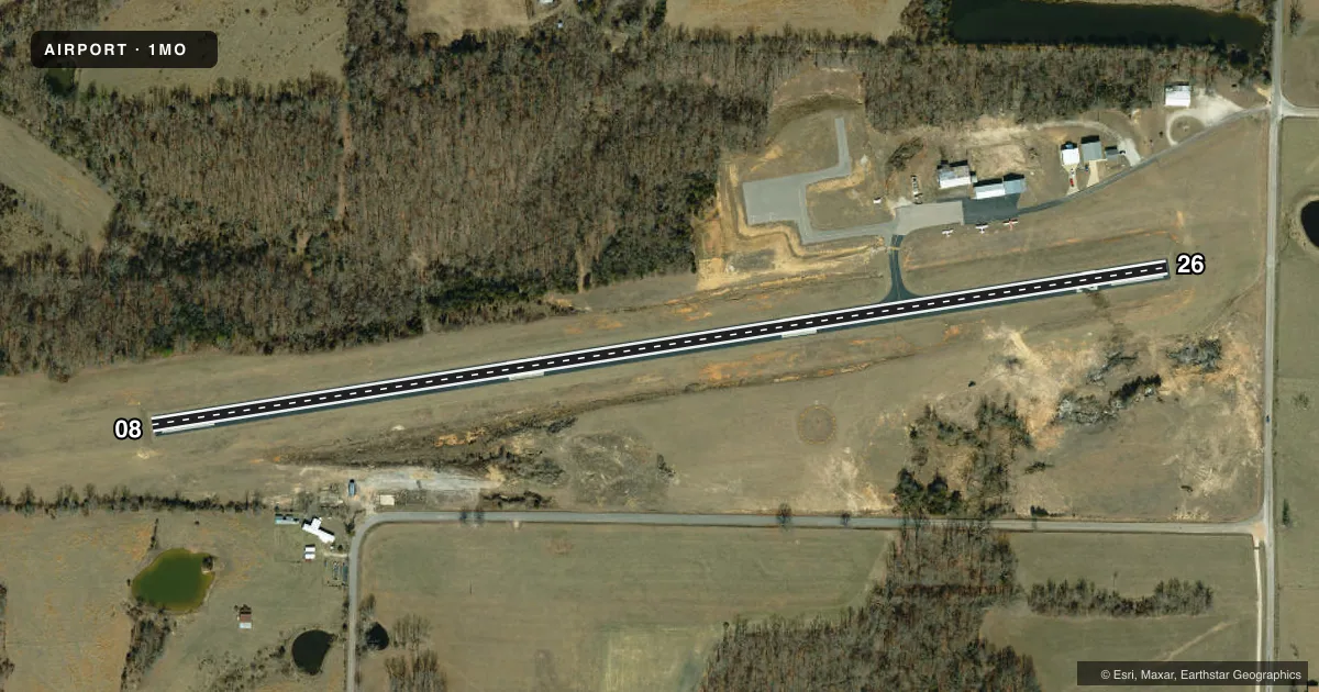
Runways & pattern
Full pagePattern entry · RWY 26
LEFT TRAFFICRunway end performance
| End | TORA | TODA | ASDA | LDA | VGSI | Approach lights | Obstruction |
|---|---|---|---|---|---|---|---|
| 08 | — | — | — | — | PAPI 2-box left(4°) | — | 51', trees, 307' from thr, 150' R of cntrln, slope 2 |
| 26 | — | — | — | — | PAPI 2-box left(4°) | — | 15', road, 285' from thr, 250' R of cntrln, slope 5 |
Declared distances in feet. TORA = takeoff run available, TODA = takeoff distance, ASDA = accelerate-stop, LDA = landing distance.
Airport sketch
Runways drawn to scale from FAA survey coordinates, rendered over satellite imagery. Not for navigation.
Approaches & charts
Services on the field
Fuel grades, oxygen, maintenance, ramp storage and lighting — as declared to the FAA by the airport operator.
Fuel & services
- Fuel
- 100LL
- Airframe repair
- Not available
- Power plant repair
- Not available
- Other services
- AGRI,INSTR,SURV
Ramp & ground
- Transient storage
- Tie-down
- Landing fee
- No fee published
- Lighting schedule
- SEE RMK
- Beacon schedule
- SS-SR
- Beacon
- White / Green (civil land)(WG)
- Wind indicator
- Lighted
- Segmented circle
- Yes
Fuel & FBOs
Cheapest 100LL and Jet A on the field and nearby. Always confirm with the FBO before taxi.
Airport notes
Surface conditions, obstructions, local procedures, lighting outages and other notes published with each FAA cycle.
General notes
- CROP DUSTING ACFT ON & INVOF ARPT.
- FOR CD CTC KANSAS CITY ARTCC AT 913-254-8508.
Lighting notes
- ROTG BCN ON WATER TOWER EAST OF ARPT.
- ACTVT REIL RWY 08 & 26; MIRL RWY 08/26 - CTAF.
- ULTRALIGHT ACTVTY ON & INVOF ARPT.
Approach & departure obstructions
- 08RWY 8 HAS 18-54 FT TREES 0-200 FT FROM RWY END 150-228 FT RIGHT AND 195-200 FT LEFT.
VFR map & nearby airports
VFR sectional. Tap any ICAO chip to open that airport.
Key facts · 1MO
Answer card- ICAO
- 1MO
- Name
- MOUNTAIN GROVE MEML
- Location
- MOUNTAIN GROVE, MISSOURI
- Elevation
- 1,476.4 ft MSL
- Traffic pattern altitude
- 2,476.4 ft MSL (1,000 AGL)
- Control tower
- Non-towered (use CTAF)
- Total runways
- 1
- Longest runway
- 08/26 · 2,922 ft
- Published ILS approaches
- 0
- Published frequencies
- 1
- Magnetic variation
- 1°
- Current flight rules
- VFR
- Current wind
- 210° at 8 kt
- Favored runway now
- RWY 26
Mountain Grove MEML is in Mountain Grove, Missouri. The field elevation is 1,476.4 ft MSL. It has one runway. Runway 08/26 is 2,922 ft long and asphalt. The airport is non-towered. CTAF is 122.9. No ILS approaches are published.
Pattern altitude is not published. Use 1,000 ft AGL for light piston operations unless the current Chart Supplement or local guidance says otherwise. That puts the standard pattern at about 2,476.4 ft MSL based on the listed field elevation. Check the current Chart Supplement before you go.
Published remarks show ultralight activity on and near the airport. Crop dusting aircraft also operate in the area. Runway 8 has trees near the departure end, so pay close attention to the runway environment on takeoff and landing. The rotating beacon is on the water tower east of the airport. Runway end identifier lights are on 08 and 26. Medium intensity runway lights are also on 08 and 26. They are controlled by CTAF.
No on-field FBOs are listed in the facts. Contact the airport operator directly before arrival, or call the field on CTAF for current service and fuel availability. For clearance delivery, contact Kansas City ARTCC at 913-254-8508. If you are planning IFR or night operations, verify current procedures and any local restrictions before departure.