METAR & TAF 03B
03B does not publish a METAR.
Showing the nearest reporting station: KLBO (FLOYD W JONES LEBANON) · 31.3 NM away. Conditions at 03B may differ.
METAR · KLBO
Observed 20:35Z
KLBO 272035Z AUTO 22012KT 10SM CLR 36/21 A2989 RMK AO2
- Wind
- 220° @ 12 kt
- Visibility
- 10 SM
- Temp / Dew
- 36°C / 21°C
- Altimeter
- 29.89 inHg
- Clouds
- CLR
- Density alt
- 4,442 ft
- Ceiling
- Unlimited
- Rules
- VFR
Airport info & contacts
Manager on record, flight service, ARTCC, attendance schedule and pattern altitude — published by the FAA and refreshed every 28 days.
Location
- From city
- 2 NM NW
- VFR sectional
- KANSAS CITY
- ARTCC
- ZKC · KANSAS CITY
- NOTAM facility
- COU (NOTAM-D)
Airport manager
- Name
- RODDY CLARK
- Phone
- 417-250-0358
- Address
- 1588 HWY F, MANSFIELD MO 65704
Flight service · Hours
- FSS COU
- COLUMBIA1-800-WX-BRIEF
- Attendance
- Unattended
Frequencies
Tap any row to copy the frequency to your clipboard.
Runways & pattern
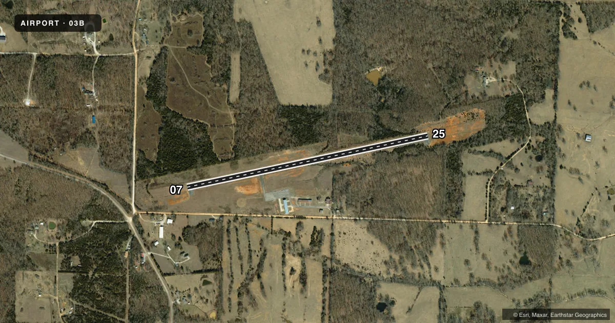
Full pagePattern entry · RWY 25
LEFT TRAFFICRunway end performance
| End | TORA | TODA | ASDA | LDA | VGSI | Approach lights | Obstruction |
|---|---|---|---|---|---|---|---|
| 07 | — | — | — | — | — | — | 45', trees, 650' from thr, 175' R of cntrln, slope 10 |
| 25 | — | — | — | — | — | — | 41', trees, 620' from thr, 120' R of cntrln, slope 10 |
Declared distances in feet. TORA = takeoff run available, TODA = takeoff distance, ASDA = accelerate-stop, LDA = landing distance.
Airport sketch
Runways drawn to scale from FAA survey coordinates, rendered over satellite imagery. Not for navigation.
Approaches & charts
Services on the field
Fuel grades, oxygen, maintenance, ramp storage and lighting — as declared to the FAA by the airport operator.
Fuel & services
- Fuel
- Not available
- Oxygen (bottled)
- Not available
- Oxygen (bulk)
- Not available
Ramp & ground
- Transient storage
- Tie-down
- Hangar
- Landing fee
- No fee published
- Customs
- Not available
- Beacon schedule
- SS-SR
- Beacon
- White / Green (civil land)(WG)
- Wind indicator
- Lighted
- Segmented circle
- Yes
Fuel & FBOs
Cheapest 100LL and Jet A on the field and nearby. Always confirm with the FBO before taxi.
Airport notes
Surface conditions, obstructions, local procedures, lighting outages and other notes published with each FAA cycle.
General notes
- DEER & OTHER WILDLIFE ON & INVOF ARPT.
- FOR CD CTC SPRINGFIELD APCH AT 417-868-5620/5619.
Approach & departure obstructions
- 25+2-7 FT BRUSH, SMALL TREES 0-50 FT FM THLD 55-105 FT L & R; +1-5 FT GND 0-200 FT FM THLD LEFT & RIGHT.
Other notes
- TIEDOWN ROPES NOT PROVIDED.
- MANAGERARPT BOARD CHAIRMAN.
- 07/25SEV DETERIORATION AND CRUMBLING ENTIRE LENGTH OF RWY.
VFR map & nearby airports
VFR sectional. Tap any ICAO chip to open that airport.
Key facts · 03B
Answer card- ICAO
- 03B
- Name
- MANSFIELD MUNI
- Location
- MANSFIELD, MISSOURI
- Elevation
- 1,520 ft MSL
- Traffic pattern altitude
- 2,520 ft MSL (1,000 AGL)
- Control tower
- Non-towered (use CTAF)
- Total runways
- 1
- Longest runway
- 07/25 · 3,000 ft
- Published ILS approaches
- 0
- Published frequencies
- 1
- Magnetic variation
- 3°
- Current flight rules
- VFR
- Current wind
- 220° at 12 kt
- Favored runway now
- RWY 25
Mansfield Muni is in Mansfield, Missouri. The field elevation is 1,520 ft MSL. It has one runway. Runway 07/25 is 3,000 ft long with an asphalt surface. The airport is not towered. CTAF is 122.9.
No ILS approaches are published here. The pattern altitude is not published in the facts, so use the standard 1,000 ft AGL pattern unless the current Chart Supplement says otherwise. There is no on-field FBO listed in the facts. Contact the airport operator directly before arrival. Or call the field on CTAF for current FBO availability.
The published remarks matter here. Deer and other wildlife are reported on and near the airport. There is brush, small trees and uneven ground close to threshold 25. Runway 07/25 also has severe deterioration and crumbling along its full length. Tiedown ropes are not provided. For clearance delivery, contact Springfield Approach at 417-868-5620 or 417-868-5619. If you are planning a first stop here, check the runway surface carefully and expect a quiet non-towered field with no published ILS support.