METAR & TAF 3DW
3DW does not publish a METAR.
Showing the nearest reporting station: KSGF (SPRINGFIELD-BRANSON NTL) · 6.8 NM away. Conditions at 3DW may differ.
METAR · KSGF
Observed 19:52Z
KSGF 271952Z 25012G20KT 10SM CLR 36/20 A2987 RMK AO2 SLP098 T03560200
- Wind
- 250° @ 12G20 kt
- Visibility
- 10 SM
- Temp / Dew
- 36°C / 20°C
- Altimeter
- 29.87 inHg
- Clouds
- CLR
- Density alt
- 4,287 ft
- Ceiling
- Unlimited
- Rules
- VFR
Airport info & contacts
Manager on record, flight service, ARTCC, attendance schedule and pattern altitude — published by the FAA and refreshed every 28 days.
Location
- From city
- 0 NM E
- VFR sectional
- KANSAS CITY
- ARTCC
- ZKC · KANSAS CITY
- NOTAM facility
- COU (NOTAM-D)
Airport manager
- Name
- LAUREN LEA
- Phone
- 417-862-2418
- Address
- 2546 E DIVISION ST, SPRINGFIELD MO 65803
Flight service · Hours
- FSS COU
- COLUMBIA1-800-WX-BRIEF
- Attendance
- MON-FRI · 0730-1800
- SAT · 0900-1600
Frequencies
Tap any row to copy the frequency to your clipboard.
Runways & pattern
Full pagePattern entry · RWY 29
LEFT TRAFFICRunway end performance
| End | TORA | TODA | ASDA | LDA | VGSI | Approach lights | Obstruction |
|---|---|---|---|---|---|---|---|
| 11 | — | — | — | — | — | — | 44', trees, 890' from thr, 116' R of cntrln, slope 15 |
| 29 | — | — | — | — | — | — | 58', trees, 1080' from thr, 130' R of cntrln, slope 15 |
Declared distances in feet. TORA = takeoff run available, TODA = takeoff distance, ASDA = accelerate-stop, LDA = landing distance.
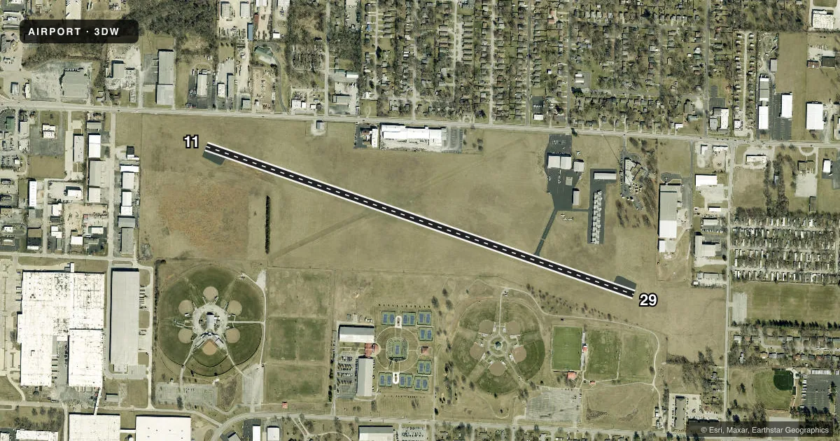
Airport sketch
Runways drawn to scale from FAA survey coordinates, rendered over satellite imagery. Not for navigation.
Approaches & charts
Services on the field
Fuel grades, oxygen, maintenance, ramp storage and lighting — as declared to the FAA by the airport operator.
Fuel & services
- Fuel
- 100LLA
- Oxygen (bottled)
- HIGH/LOW
- Oxygen (bulk)
- Not available
- Airframe repair
- Major
- Power plant repair
- Major
Ramp & ground
- Transient storage
- Tie-down
- Hangar
- Landing fee
- No fee published
- Customs
- Not available
- Lighting schedule
- SEE RMK
- Wind indicator
- Lighted
- Segmented circle
- No
Fuel & FBOs
Cheapest 100LL and Jet A on the field and nearby. Always confirm with the FBO before taxi.
Airport notes
Surface conditions, obstructions, local procedures, lighting outages and other notes published with each FAA cycle.
General notes
- 600 FT LGTD TOWER 950 FT N OF RY 29 THLD.
- NTSD RY SAFETY AREA BYD RY 29 THLD; LARGE SLOPE.
- PEDESTRIAN GATE CODE IS CTAF FREQ.
- FOR CD CTC SPRINGFIELD APCH AT 417-868-5620/5619.
Lighting notes
- ACTVT NSTD MIRL RWY 11/29 - CTAF-THREE CLICKS.
Runway surface & condition
- 11/29NSTD MIRL; 3 THR LGTS EACH RWY, EDGE LGTS SPACED 240 FT APART.
Other notes
- PRVDD APCH SLOPES ARE MAINT FOR 20:1 & TRSNL SFC 7:1.
VFR map & nearby airports
VFR sectional. Tap any ICAO chip to open that airport.
Key facts · 3DW
Answer card- ICAO
- 3DW
- Name
- DOWNTOWN
- Location
- SPRINGFIELD, MISSOURI
- Elevation
- 1,375 ft MSL
- Traffic pattern altitude
- 2,375 ft MSL (1,000 AGL)
- Control tower
- Non-towered (use CTAF)
- Total runways
- 1
- Longest runway
- 11/29 · 4,037 ft
- Published ILS approaches
- 0
- Published frequencies
- 4
- Magnetic variation
- 1°
- Current flight rules
- VFR
- Current wind
- 250° at 12 kt
- Favored runway now
- RWY 29
Downtown Airport (3DW) is in Springfield, Missouri. The field elevation is 1,375 ft MSL. It has one runway. Runway 11/29 is 4,037 ft long and paved with asphalt. There is no control tower, so CTAF and UNICOM are both 122.8. Springfield Approach uses 124.95 and 353.925 for approach and departure work. No ILS approaches are published here.
Pattern altitude is not published. Use 1,000 ft AGL for light piston operations unless the current Chart Supplement says otherwise. That puts the pattern at about 2,375 ft MSL based on the listed field elevation. Springfield Flying Service is on the field. It carries AVGAS 100LL and Jet A. Call them at (417) 862-2418 before you go.
A few operational details matter here. The runway lights are nonstandard medium intensity lights. They are activated by clicking the CTAF three times. There is a 600 ft lighted tower 950 ft north of the Runway 29 threshold. The runway safety area beyond Runway 29 is not standard and has a large slope. Clearance delivery can be handled through Springfield Approach at 417-868-5620 or 417-868-5619. Check the current Chart Supplement for any noise or curfew restrictions before flying into the field.