METAR & TAF MO2
MO2 does not publish a METAR.
Showing the nearest reporting station: KSGF (SPRINGFIELD-BRANSON NTL) · 13.1 NM away. Conditions at MO2 may differ.
METAR · KSGF
Observed 14:52Z
KSGF 271452Z 21008KT 10SM CLR 31/21 A2996 RMK AO2 SLP127 T03110206 58000
- Wind
- 210° @ 8 kt
- Visibility
- 10 SM
- Temp / Dew
- 31°C / 21°C
- Altimeter
- 29.96 inHg
- Clouds
- CLR
- Density alt
- 3,582 ft
- Ceiling
- Unlimited
- Rules
- VFR
Airport info & contacts
Manager on record, flight service, ARTCC, attendance schedule and pattern altitude — published by the FAA and refreshed every 28 days.
Location
- From city
- 8 NM E
- VFR sectional
- KANSAS CITY
- ARTCC
- ZKC · KANSAS CITY
- NOTAM facility
- COU (NOTAM-D)
Airport manager
- Name
- DAVID W. HALL
- Phone
- (417) 886-2677
- Address
- 2204 S FARM RD 225, ROGERSVILLE MO 65742
Flight service · Hours
- FSS COU
- COLUMBIA1-800-WX-BRIEF
- Attendance
- Unattended
Frequencies
Tap any row to copy the frequency to your clipboard.
Runways & pattern
Full pagePattern entry · RWY 24
LEFT TRAFFICRunway end performance
| End | TORA | TODA | ASDA | LDA | VGSI | Approach lights | Obstruction |
|---|---|---|---|---|---|---|---|
| 06 | — | — | — | — | — | — | 60', trees, 15' from thr, 125' R of cntrln, slope 0 |
| 24 | — | — | — | — | — | — | 55', trees, 50' from thr, 125' R of cntrln, slope 0 |
Declared distances in feet. TORA = takeoff run available, TODA = takeoff distance, ASDA = accelerate-stop, LDA = landing distance.
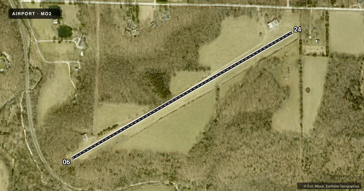
Airport sketch
Runways drawn to scale from FAA survey coordinates, rendered over satellite imagery. Not for navigation.
Approaches & charts
Services on the field
Fuel grades, oxygen, maintenance, ramp storage and lighting — as declared to the FAA by the airport operator.
Fuel & services
- Fuel
- Not available
- Oxygen (bottled)
- Not available
- Oxygen (bulk)
- Not available
Ramp & ground
- Transient storage
- Not published
- Landing fee
- No fee published
- Wind indicator
- Yes
- Segmented circle
- No
Fuel & FBOs
Cheapest 100LL and Jet A on the field and nearby. Always confirm with the FBO before taxi.
Airport notes
Surface conditions, obstructions, local procedures, lighting outages and other notes published with each FAA cycle.
General notes
- WILDLIFE ON & INVOF ARPT.
- AFTER HEAVY RAINS CALL 417-887-5483 FOR RY CONDS.
- LARGE TREES AT NE END OF RY & LARGE TREES ON SIDES OF RY AT SW END.
- OWNER RECOMMENDS LANDING & DEP TO THE SW WINDS PERMITTING.
- NTSD RY SAFETY AREAS BYND EACH RY END & ALONG RY EDGES; INCORRECT TERRAIN GRADES, NO OVERRUN AT EACH END, LARGE DROP OFF AT RY 06 THLD.
- FOR CD CTC SPRINGFIELD APCH AT 417-868-5620/5619.
Other notes
- WIND SOCK LCTD ON TOP OF HANGAR EACH END.
- 06/24ROLLING & UNEVEN
VFR map & nearby airports
VFR sectional. Tap any ICAO chip to open that airport.
Key facts · MO2
Answer card- ICAO
- MO2
- Name
- FLYING BAR H RANCH
- Location
- SPRINGFIELD, MISSOURI
- Elevation
- 1,380 ft MSL
- Traffic pattern altitude
- 2,380 ft MSL (1,000 AGL)
- Control tower
- Non-towered (use CTAF)
- Total runways
- 1
- Longest runway
- 06/24 · 2,640 ft
- Published ILS approaches
- 0
- Published frequencies
- 1
- Magnetic variation
- 4°
- Current flight rules
- VFR
- Current wind
- 210° at 8 kt
- Favored runway now
- RWY 24
Flying Bar H Ranch Airport is in Springfield, Missouri. Field elevation is 1,380 ft MSL. It has one runway, 06/24, which is 2,640 ft long and surfaced with turf. There is no control tower. CTAF is 122.9. No ILS approaches are published.
Pattern altitude is not published. Use 1,000 ft AGL for light piston traffic unless the current Chart Supplement says otherwise. The runway is rolling and uneven. Wildlife is reported on and near the airport. Large trees sit near the northeast end of the runway. Large trees are also on the sides of the runway at the southwest end. The owner recommends landing and departing to the southwest when winds permit. The wind sock is on top of the hangar at each end.
There are no on-field FBOs listed. Check with the airport operator or the FBO directly by phone before arrival if you need fuel or local support. After heavy rain, call for runway conditions before you go in. Clearance delivery is handled through Springfield Approach by phone when needed. This is a small turf field with non-standard runway safety areas. It has no overrun. There is a large drop-off at the 06 threshold. Plan your rollout and departure with that in mind.