METAR & TAF K33
K33 does not publish a METAR.
Showing the nearest reporting station: KTBN (WAYNESVILLE-ST ROBERT RGNL FORNEY FLD) · 26.6 NM away. Conditions at K33 may differ.
METAR · KTBN
Observed 18:55Z
KTBN 271855Z AUTO 21007KT 10SM FEW050 36/24 A2985 RMK AO2 SLP095 T03560235 $
- Wind
- 210° @ 7 kt
- Visibility
- 10 SM
- Temp / Dew
- 36°C / 24°C
- Altimeter
- 29.85 inHg
- Clouds
- FEW
- Density alt
- 4,146 ft
- Ceiling
- Unlimited
- Rules
- VFR
Airport info & contacts
Manager on record, flight service, ARTCC, attendance schedule and pattern altitude — published by the FAA and refreshed every 28 days.
Location
- From city
- 4 NM SW
- VFR sectional
- KANSAS CITY
- Pattern altitude
- 800 ft AGL · 2,041 ft MSL
- ARTCC
- ZKC · KANSAS CITY
- NOTAM facility
- STL (NOTAM-D)
Airport manager
- Name
- BRENT YOUNG
- Phone
- 573-729-5900
- Address
- 400 NORTH IRON STREET, SALEM MO 65560
Flight service · Hours
- FSS STL
- SAINT LOUIS1-800-WX-BRIEF
- Attendance
- Unattended
Frequencies
Tap any row to copy the frequency to your clipboard.
Runways & pattern
Full pagePattern entry · RWY 17
LEFT TRAFFICRunway end performance
| End | TORA | TODA | ASDA | LDA | VGSI | Approach lights | Obstruction |
|---|---|---|---|---|---|---|---|
| 17 | — | — | — | — | PAPI 2-box left(3°) | — | — |
| 35 | — | — | — | — | PAPI 2-box left(3°) | — | — |
Declared distances in feet. TORA = takeoff run available, TODA = takeoff distance, ASDA = accelerate-stop, LDA = landing distance.
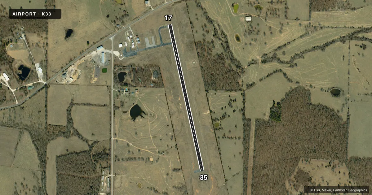
Airport sketch
Runways drawn to scale from FAA survey coordinates, rendered over satellite imagery. Not for navigation.
Approaches & charts
Services on the field
Fuel grades, oxygen, maintenance, ramp storage and lighting — as declared to the FAA by the airport operator.
Fuel & services
- Fuel
- 100LL
Ramp & ground
- Transient storage
- Tie-down
- Landing fee
- No fee published
- Lighting schedule
- SEE RMK
- Beacon schedule
- SS-SR
- Beacon
- White / Green (civil land)(WG)
- Wind indicator
- Lighted
- Segmented circle
- Yes
Fuel & FBOs
Cheapest 100LL and Jet A on the field and nearby. Always confirm with the FBO before taxi.
Airport notes
Surface conditions, obstructions, local procedures, lighting outages and other notes published with each FAA cycle.
General notes
- FOR CD CTC KANSAS CITY ARTCC AT 913-254-8508.
Lighting notes
- ACTVT MIRL RY 17/35 - CTAF; TO INCR INTST & ACTVT REIL RYS 17 & 35 - CTAF
Fuel notes
- 100LLSELF SVC FUEL AVBL 24 HRS.
Other notes
- ESTABD PRIOR TO OCT.1959.
VFR map & nearby airports
VFR sectional. Tap any ICAO chip to open that airport.
Key facts · K33
Answer card- ICAO
- K33
- Name
- SALEM MEML
- Location
- SALEM, MISSOURI
- Elevation
- 1,241.2 ft MSL
- Traffic pattern altitude
- 2,041.2 ft MSL (800 AGL)
- Control tower
- Non-towered (use CTAF)
- Total runways
- 1
- Longest runway
- 17/35 · 2,998 ft
- Published ILS approaches
- 0
- Published frequencies
- 1
- Magnetic variation
- 2°
- Current flight rules
- VFR
- Current wind
- 210° at 7 kt
- Favored runway now
- RWY 17
Salem Memorial Airport is in Salem, Missouri. The field elevation is 1,241.2 ft MSL. It has one runway. Runway 17/35 is 2,998 ft long with an asphalt surface. There is no control tower. CTAF is 122.9. The published pattern altitude is 800 ft AGL, which is 2,041.2 ft MSL.
No ILS approaches are published here. That matters if you are planning an IFR arrival. Check the current FAA Chart Supplement for the latest approach and airport data before you go. The published remarks also note that 100LL self-service fuel is available 24 hours. Runway lights on 17/35 are activated by CTAF. Use CTAF to increase light intensity. It also activates the runway end identifier lights on 17 and 35.
There are no on-field FBOs listed in the facts. FBO options vary. Contact the airport operator directly before arrival, or call the field on CTAF for current FBO availability. The airport is not towered, so expect self-announce traffic and pay close attention in the pattern. Clearance delivery for IFR departures is handled through Kansas City ARTCC at the published number. The field sits at moderate elevation, so performance planning should account for density altitude on warm days.