METAR & TAF KUBX
KUBX does not publish a METAR.
Showing the nearest reporting station: KUUV (SULLIVAN RGNL) · 15.9 NM away. Conditions at KUBX may differ.
METAR · KUUV
Observed 16:15Z
KUUV 271615Z AUTO 21011G14KT 10SM CLR CLR A2996 RMK AO2
- Wind
- 210° @ 11G14 kt
- Visibility
- 10 SM
- Temp / Dew
- —
- Altimeter
- 29.96 inHg
- Clouds
- CLR
- Density alt
- —
- Ceiling
- Unlimited
- Rules
- VFR
Airport info & contacts
Manager on record, flight service, ARTCC, attendance schedule and pattern altitude — published by the FAA and refreshed every 28 days.
Location
- From city
- 1 NM NW
- VFR sectional
- KANSAS CITY
- ARTCC
- ZKC · KANSAS CITY
- NOTAM facility
- STL (NOTAM-D)
Airport manager
- Name
- TRAVIS PRITCHETT
- Phone
- 573-885-2479
- Address
- 1312 HWY DD, CUBA MO 65453
Flight service · Hours
- FSS STL
- SAINT LOUIS1-800-WX-BRIEF
- Attendance
- SUN · 1230-1630
- MON-WED · 0830-1630
- FRI-SAT · 0830-1630
Frequencies
Tap any row to copy the frequency to your clipboard.
Runways & pattern
Full pagePattern entry · RWY 19
LEFT TRAFFICRunway end performance
| End | TORA | TODA | ASDA | LDA | VGSI | Approach lights | Obstruction |
|---|---|---|---|---|---|---|---|
| 01 | — | — | — | — | PAPI 2-box left(3.25°) | — | — |
| 19 | — | — | — | — | PAPI 2-box left(3°) | — | — |
Declared distances in feet. TORA = takeoff run available, TODA = takeoff distance, ASDA = accelerate-stop, LDA = landing distance.
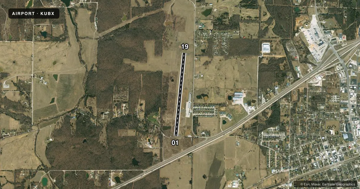
Airport sketch
Runways drawn to scale from FAA survey coordinates, rendered over satellite imagery. Not for navigation.
Approaches & charts
Services on the field
Fuel grades, oxygen, maintenance, ramp storage and lighting — as declared to the FAA by the airport operator.
Fuel & services
- Fuel
- 100LL
- Oxygen (bottled)
- Not available
- Oxygen (bulk)
- Not available
- Airframe repair
- Major
- Power plant repair
- Major
- Other services
- INSTR,RNTL
Ramp & ground
- Transient storage
- Tie-down
- Hangar
- Landing fee
- No fee published
- Customs
- Not available
- Lighting schedule
- SEE RMK
- Beacon schedule
- SS-SR
- Beacon
- White / Green (civil land)(WG)
- Wind indicator
- Lighted
- Segmented circle
- Yes
Fuel & FBOs
Cheapest 100LL and Jet A on the field and nearby. Always confirm with the FBO before taxi.
Airport notes
Surface conditions, obstructions, local procedures, lighting outages and other notes published with each FAA cycle.
General notes
- FOR CD CTC KANSAS CITY ARTCC AT 913-254-8508.
Lighting notes
- ACTVT REIL RWY 01 & 19; PAPI RWY 01 & 19; MIRL RWY 01/19 - CTAF.
Fuel notes
- 100LLSELF SERVICE FUEL AVBL 24 HRS A DAY
Other notes
- UNICOM UNMON.
- MANAGERAFTER HOURS PHONE 573-578-5188
VFR map & nearby airports
VFR sectional. Tap any ICAO chip to open that airport.
Key facts · KUBX
Answer card- ICAO
- KUBX
- Name
- CUBA MUNI
- Location
- CUBA, MISSOURI
- Elevation
- 1,023 ft MSL
- Traffic pattern altitude
- 2,023 ft MSL (1,000 AGL)
- Control tower
- Non-towered (use CTAF)
- Total runways
- 1
- Longest runway
- 01/19 · 3,420 ft
- Published ILS approaches
- 0
- Published frequencies
- 2
- Magnetic variation
- 1°
- Current flight rules
- VFR
- Current wind
- 210° at 11 kt
- Favored runway now
- RWY 19
Cuba Muni sits in Cuba, Missouri. The field elevation is 1,023 ft MSL. It has one runway. Runway 01/19 is 3,420 ft long and asphalt. There is no control tower. CTAF and UNICOM are both 122.8. UNICOM is unmonitored.
No ILS approaches are published here. Pattern altitude is not published, so use the standard 1,000 ft AGL for light piston traffic unless the current Chart Supplement says otherwise. Runway 01 and 19 have runway end identifier lights and PAPI. Medium intensity runway lights are on 01/19. They are controlled by CTAF. Self-serve 100LL is available 24 hours a day at the on-field Cuba Municipal Airport FBO. Clearance delivery for IFR departures goes through Kansas City ARTCC at 913-254-8508. The after-hours phone number listed in the remarks is 573-578-5188.
For a first-time arrival, the main things to plan for are the non-towered pattern, the published lighting setup and the lack of ILS. Verify current runway and lighting status before a night or low-weather arrival. If you need current operational details, call the airport operator or the FBO directly.