METAR & TAF KFYG
Current METAR
Observed 17:15Z
KFYG 261715Z AUTO 00000KT 4SM HZ CLR 34/30 A2993 RMK AO2
- Wind
- 000° @ 0 kt
- Visibility
- 4 SM
- Temp / Dew
- 34°C / 30°C
- Altimeter
- 29.93 inHg
- Clouds
- CLR
- Density alt
- 2,872 ft
- Ceiling
- Unlimited
- Rules
- MVFR
Airport info & contacts
Manager on record, flight service, ARTCC, attendance schedule and pattern altitude — published by the FAA and refreshed every 28 days.
Location
- From city
- 3 NM N
- VFR sectional
- ST LOUIS
- ARTCC
- ZKC · KANSAS CITY
- NOTAM facility
- STL (NOTAM-D)
Airport manager
- Name
- KEVIN HELLMANN
- Phone
- 636-283-4220
- Address
- 405 JEFFERSON ST., WASHINGTON MO 63090
Flight service · Hours
- FSS STL
- SAINT LOUIS1-800-WX-BRIEF
- Attendance
- NOV-MAR · 0800-1700
- APR-OCT · 0800-1800
Frequencies
Tap any row to copy the frequency to your clipboard.
Runways & pattern
Full pagePattern entry · RWY 15
RIGHT TRAFFICRunway end performance
| End | TORA | TODA | ASDA | LDA | VGSI | Approach lights | Obstruction |
|---|---|---|---|---|---|---|---|
| 15 | — | — | — | — | PAPI 4-box left(3°) | — | — |
| 33 | — | — | — | — | PAPI 4-box left(3°) | — | — |
Declared distances in feet. TORA = takeoff run available, TODA = takeoff distance, ASDA = accelerate-stop, LDA = landing distance.
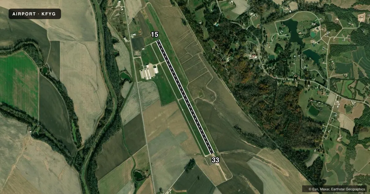
Airport sketch
Runways drawn to scale from FAA survey coordinates, rendered over satellite imagery. Not for navigation.
Approaches & charts
Services on the field
Fuel grades, oxygen, maintenance, ramp storage and lighting — as declared to the FAA by the airport operator.
Fuel & services
- Fuel
- 100LLA+
- Airframe repair
- Major
- Power plant repair
- Major
- Other services
- INSTR
Ramp & ground
- Transient storage
- Tie-down
- Landing fee
- No fee published
- Customs
- Not available
- Lighting schedule
- SEE RMK
- Beacon schedule
- SS-SR
- Beacon
- White / Green (civil land)(WG)
- Wind indicator
- Lighted
- Segmented circle
- Yes
Fuel & FBOs
Cheapest 100LL and Jet A on the field and nearby. Always confirm with the FBO before taxi.
Airport notes
Surface conditions, obstructions, local procedures, lighting outages and other notes published with each FAA cycle.
General notes
- LARGE WATERFOWL AND WILDLIFE ON AND INVOF ARPT
- FOR CD CTC ST LOUIS APCH AT 314-890-1017.
Lighting notes
- MIRL RWY 15/33 PRESET ON MED INTST DUSK TO 0000; TO INCR INTST & ACTVT REIL RWYS 15 & 33 AND MIRL RWY 15/33 - CTAF. PAPI RWYS 15 & 33 OPR CONSLY.
VFR map & nearby airports
VFR sectional. Tap any ICAO chip to open that airport.
Key facts · KFYG
Answer card- ICAO
- KFYG
- Name
- WASHINGTON RGNL
- Location
- WASHINGTON, MISSOURI
- Elevation
- 487.7 ft MSL
- Traffic pattern altitude
- 1,487.7 ft MSL (1,000 AGL)
- Control tower
- Non-towered (use CTAF)
- Total runways
- 1
- Longest runway
- 15/33 · 5,002 ft
- Published ILS approaches
- 0
- Published frequencies
- 4
- Magnetic variation
- 1°
- Current flight rules
- MVFR
- Current wind
- 000° at 0 kt
- Favored runway now
- –
Washington Rgnl is in Washington, Missouri. The field elevation is 487.7 ft MSL. It has one runway. Runway 15/33 is 5,002 ft long and is the longest runway on the field. There is no control tower. CTAF and UNICOM are both 122.8. Approach and departure service is handled by St Louis Approach on 126.5 or 254.3.
No ILS approaches are published here. The pattern altitude is not published in the facts, so use the standard 1,000 ft AGL pattern for light piston operations unless the current Chart Supplement says otherwise. The published remarks also note that medium intensity runway lights on 15/33 are preset from dusk to 0000 hours. You can use the CTAF to increase intensity and to activate the runway end identifier lights. The PAPI on 15 and 33 operates continuously.
Washington Aviation is on the field. It carries 100LL and Jet A. Its phone number is (636) 433-5454. Large waterfowl and wildlife are reported on and near the airport, so keep a sharp scan on arrival and departure. For clearance delivery, contact St Louis Approach at 314-890-1017. Check the current FAA Chart Supplement for any updated operational notes before you fly in.