METAR & TAF 63M
63M does not publish a METAR.
Showing the nearest reporting station: KFYG (WASHINGTON RGNL) · 24.3 NM away. Conditions at 63M may differ.
METAR · KFYG
Observed 12:15Z
KFYG 271215Z AUTO 12008KT 8SM CLR 27/27 A2993 RMK AO2
- Wind
- 120° @ 8 kt
- Visibility
- 8 SM
- Temp / Dew
- 27°C / 27°C
- Altimeter
- 29.93 inHg
- Clouds
- CLR
- Density alt
- 2,057 ft
- Ceiling
- Unlimited
- Rules
- VFR
Airport info & contacts
Manager on record, flight service, ARTCC, attendance schedule and pattern altitude — published by the FAA and refreshed every 28 days.
Location
- From city
- 3 NM NW
- VFR sectional
- KANSAS CITY
- ARTCC
- ZKC · KANSAS CITY
- NOTAM facility
- STL (NOTAM-D)
Airport manager
- Name
- GARY GEISLER
- Phone
- 573-486-3370
- Address
- 228 E. 1ST STREET, HERMANN MO 65041
Flight service · Hours
- FSS STL
- SAINT LOUIS1-800-WX-BRIEF
- Attendance
- Unattended
Frequencies
Tap any row to copy the frequency to your clipboard.
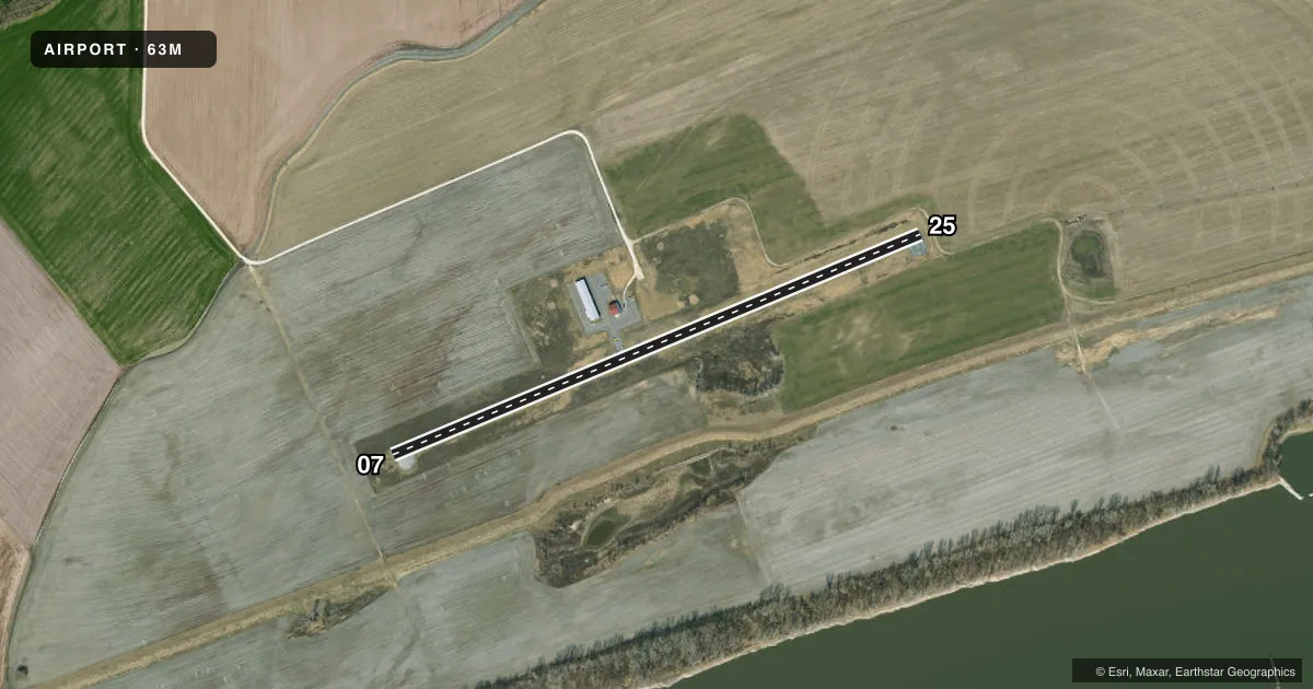
Runways & pattern
Full pagePattern entry · RWY 07
LEFT TRAFFICRunway end performance
| End | TORA | TODA | ASDA | LDA | VGSI | Approach lights | Obstruction |
|---|---|---|---|---|---|---|---|
| 25 | — | — | — | — | PAPI 2-box left(3°) | — | — |
Declared distances in feet. TORA = takeoff run available, TODA = takeoff distance, ASDA = accelerate-stop, LDA = landing distance.
Airport sketch
Runways drawn to scale from FAA survey coordinates, rendered over satellite imagery. Not for navigation.
Approaches & charts
Services on the field
Fuel grades, oxygen, maintenance, ramp storage and lighting — as declared to the FAA by the airport operator.
Fuel & services
- Fuel
- Not available
- Oxygen (bottled)
- Not available
- Oxygen (bulk)
- Not available
- Power plant repair
- Not available
- Other services
- AGRI,CHTR,INSTR
Ramp & ground
- Transient storage
- Tie-down
- Hangar
- Landing fee
- No fee published
- Lighting schedule
- SEE RMK
- Beacon schedule
- SS-SR
- Beacon
- White / Green (civil land)(WG)
- Wind indicator
- Lighted
- Segmented circle
- Yes
Fuel & FBOs
Cheapest 100LL and Jet A on the field and nearby. Always confirm with the FBO before taxi.
Airport notes
Surface conditions, obstructions, local procedures, lighting outages and other notes published with each FAA cycle.
General notes
- BIRDS ON AND IN VICINITY OF ARPT.
- BE ALERT TO LARGE AGRICULTURAL IRRIGATION SYSTEM DURING SPRING AND SUMMER MONTHS, APRX 300-400 FT FM RY 25 END.
- PWR TRANSMISSION LINES AND CATENARY SUPPORT STRUCTURE 2600 FT FM RWY 25 THLD ON EXTENDED RWY CNTRLN.
- USE CTN OPRG ON TWY AND APN - PAVEMENT SEVERELY DTRTD - FOD HAZ.
- FOR CD CTC MIZZOU APCH AT 417-868-5620/5619.
Lighting notes
- ACTIVATE MIRL RY 07/25, PAPI RY 25 - CTAF.
VFR map & nearby airports
VFR sectional. Tap any ICAO chip to open that airport.
Key facts · 63M
Answer card- ICAO
- 63M
- Name
- HERMANN MUNI
- Location
- HERMANN, MISSOURI
- Elevation
- 507.5 ft MSL
- Traffic pattern altitude
- 1,507.5 ft MSL (1,000 AGL)
- Control tower
- Non-towered (use CTAF)
- Total runways
- 1
- Longest runway
- 07/25 · 3,198 ft
- Published ILS approaches
- 0
- Published frequencies
- 1
- Magnetic variation
- 3°
- Current flight rules
- VFR
- Current wind
- 120° at 8 kt
- Favored runway now
- RWY 07
Hermann Muni is in Hermann, Missouri. The field elevation is 507.5 ft MSL. It has one runway, 07/25, which is 3,198 ft of asphalt. There is no control tower. CTAF is 122.9.
No ILS approaches are published here. The pattern altitude is not published, so use the standard 1,000 ft AGL pattern unless the current Chart Supplement says otherwise. The airport has no on-field FBOs listed, so plan ahead and contact the airport operator or the field directly if you need fuel or ramp details.
The published remarks matter here. Be alert for a large agricultural irrigation system near the runway 25 end in spring and summer. Taxiway and apron pavement are severely deteriorated, so watch for foreign object debris. Power transmission lines and a catenary support structure sit on the extended centerline beyond runway 25. Birds are also reported on and near the airport. For lighting, medium intensity runway lights are activated on CTAF for runway 07/25, along with the PAPI for runway 25. This is a non-towered field, so standard self-announce traffic discipline matters. If you need clearance delivery, contact Mizzou Approach by phone before departure.