METAR & TAF 1H3
1H3 does not publish a METAR.
Showing the nearest reporting station: KJEF (JEFFERSON CITY MEML) · 17.5 NM away. Conditions at 1H3 may differ.
METAR · KJEF
Observed 15:53Z
KJEF 271553Z 20009KT 10SM CLR 32/23 A2988 RMK AO2 SLP103 T03220233 $
- Wind
- 200° @ 9 kt
- Visibility
- 10 SM
- Temp / Dew
- 32°C / 23°C
- Altimeter
- 29.88 inHg
- Clouds
- CLR
- Density alt
- 3,271 ft
- Ceiling
- Unlimited
- Rules
- VFR
Airport info & contacts
Manager on record, flight service, ARTCC, attendance schedule and pattern altitude — published by the FAA and refreshed every 28 days.
Location
- From city
- 2 NM SE
- VFR sectional
- KANSAS CITY
- ARTCC
- ZKC · KANSAS CITY
- NOTAM facility
- COU (NOTAM-D)
Airport manager
- Name
- BRAD CREDE
- Phone
- 573-897-5323
- Address
- ONE TECHNOLOGY DR, LINN MO 65051
Flight service · Hours
- FSS COU
- COLUMBIA1-800-WX-BRIEF
- Attendance
- MON-FRI · IREG
Frequencies
Tap any row to copy the frequency to your clipboard.
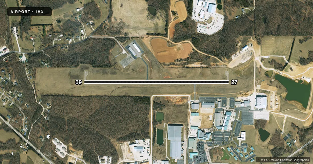
Runways & pattern
Full pagePattern entry · RWY 27
LEFT TRAFFICRunway end performance
| End | TORA | TODA | ASDA | LDA | VGSI | Approach lights | Obstruction |
|---|---|---|---|---|---|---|---|
| 09 | — | — | — | — | PAPI 4-box left(3.3°) | — | — |
| 27 | — | — | — | — | PAPI 4-box left(3°) | — | 33', trees, 726' from thr, 90' R of cntrln, slope 15 |
Declared distances in feet. TORA = takeoff run available, TODA = takeoff distance, ASDA = accelerate-stop, LDA = landing distance.
Airport sketch
Runways drawn to scale from FAA survey coordinates, rendered over satellite imagery. Not for navigation.
Approaches & charts
Services on the field
Fuel grades, oxygen, maintenance, ramp storage and lighting — as declared to the FAA by the airport operator.
Fuel & services
- Fuel
- 100LL
- Airframe repair
- Not available
- Power plant repair
- Not available
Ramp & ground
- Transient storage
- Tie-down
- Lighting schedule
- SEE RMK
- Beacon
- White / Green (civil land)(WG)
- Wind indicator
- Lighted
- Segmented circle
- No
Fuel & FBOs
Cheapest 100LL and Jet A on the field and nearby. Always confirm with the FBO before taxi.
Airport notes
Surface conditions, obstructions, local procedures, lighting outages and other notes published with each FAA cycle.
General notes
- DEER ON & INVOF ARPT.
- WATERFOWL ON & INVOF ARPT.
- FOR CD CTC MIZZOU APCH AT 417-868-5620/5619.
Lighting notes
- DUSK-DAWN. MIRL RY 09/27 PRESET ON MED INTST; TO INCR INTST & ACTVT RYS 09 & 27 REIL, PAPI & WINDSOCK - CTAF.
Fuel notes
- 100LLFUEL SELF SVC 24 HRS.
Approach & departure obstructions
- 27REILS RY 27 OTS INDEFLY.
Other notes
- PRVDD A CLEAR APCH EA RY FOR A 20:1 GLIDE SLOPE & A CLEAR TRANSITIONAL SFC FOR A 7:1 SLOPE.
- MANAGEREXT. 5138
VFR map & nearby airports
VFR sectional. Tap any ICAO chip to open that airport.
Key facts · 1H3
Answer card- ICAO
- 1H3
- Name
- STATE TECHNICAL COLLEGE OF MISSOURI
- Location
- LINN, MISSOURI
- Elevation
- 952.6 ft MSL
- Traffic pattern altitude
- 1,952.6 ft MSL (1,000 AGL)
- Control tower
- Non-towered (use CTAF)
- Total runways
- 1
- Longest runway
- 09/27 · 3,400 ft
- Published ILS approaches
- 0
- Published frequencies
- 1
- Magnetic variation
- 2°
- Current flight rules
- VFR
- Current wind
- 200° at 9 kt
- Favored runway now
- RWY 27
State Technical College of Missouri Airport (1H3) sits in Linn, Missouri. Field elevation is 952.6 ft MSL. The airport has one runway. Runway 09/27 is 3,400 ft long with a concrete surface. The field is non-towered. CTAF 122.9 is the working frequency for local traffic. No ILS approaches are published here.
Pattern altitude is not published. Use 1,000 ft AGL for light piston operations unless the current FAA Chart Supplement says otherwise. The airport publishes a clear approach path for each runway with a 20:1 glide slope. It also has a clear transitional surface for a 7:1 slope. Deer and waterfowl are reported on and near the airport. Keep a sharp scan on arrival and departure. Runway lighting is preset from dusk to dawn. Use the CTAF to increase intensity and to activate runway end identifier lights, PAPI and the windsock. REIL on runway 27 are out of service indefinitely.
State Technical College of Missouri is the on-field FBO. It carries 100LL. Self-serve 100LL is available 24 hours. For clearance delivery, contact Mizzou Approach by phone before departure. First-time pilots should plan for a quiet non-towered field with wildlife on the movement area. Published lighting details matter after dark.