METAR & TAF H57
H57 does not publish a METAR.
Showing the nearest reporting station: KFAM (FARMINGTON RGNL) · 8.9 NM away. Conditions at H57 may differ.
METAR · KFAM
Observed 14:56Z
KFAM 271456Z AUTO 20009KT 10SM CLR 29/23 A2997 RMK AO2 SLP149 T02940228 58009 $
- Wind
- 200° @ 9 kt
- Visibility
- 10 SM
- Temp / Dew
- 29°C / 23°C
- Altimeter
- 29.97 inHg
- Clouds
- CLR
- Density alt
- 2,905 ft
- Ceiling
- Unlimited
- Rules
- VFR
Airport info & contacts
Manager on record, flight service, ARTCC, attendance schedule and pattern altitude — published by the FAA and refreshed every 28 days.
Location
- From city
- 1 NM SE
- VFR sectional
- ST LOUIS
- ARTCC
- ZKC · KANSAS CITY
- NOTAM facility
- STL (NOTAM-D)
Airport manager
- Name
- ALEXANDER BISCHOFF
- Phone
- 415-377-7070
- Address
- P.O. BOX 292, PO BOX 262, BISMARCK MO 63624
Flight service · Hours
- FSS STL
- SAINT LOUIS1-800-WX-BRIEF
- Attendance
- IREG
Frequencies
Tap any row to copy the frequency to your clipboard.
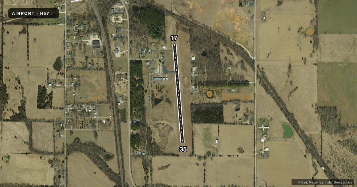
Runways & pattern
Full pagePattern entry · RWY 17
LEFT TRAFFICRunway end performance
| End | TORA | TODA | ASDA | LDA | VGSI | Approach lights | Obstruction |
|---|---|---|---|---|---|---|---|
| 17 | — | — | — | — | — | — | 36', trees, 491' from thr, 141' R of cntrln, slope 8 |
| 35 | — | — | — | — | — | — | 12', tree, 259' from thr, 121' R of cntrln, slope 4 |
Declared distances in feet. TORA = takeoff run available, TODA = takeoff distance, ASDA = accelerate-stop, LDA = landing distance.
Airport sketch
Runways drawn to scale from FAA survey coordinates, rendered over satellite imagery. Not for navigation.
Approaches & charts
Services on the field
Fuel grades, oxygen, maintenance, ramp storage and lighting — as declared to the FAA by the airport operator.
Fuel & services
- Fuel
- Not available
- Oxygen (bottled)
- Not available
- Oxygen (bulk)
- Not available
- Airframe repair
- Not available
- Power plant repair
- Not available
Ramp & ground
- Transient storage
- Tie-down
- Landing fee
- No fee published
- Customs
- Not available
- Lighting schedule
- SS-SR
- Beacon schedule
- SS-SR
- Beacon
- White / Green (civil land)(WG)
- Wind indicator
- Yes
- Segmented circle
- Yes
Fuel & FBOs
Cheapest 100LL and Jet A on the field and nearby. Always confirm with the FBO before taxi.
Airport notes
Surface conditions, obstructions, local procedures, lighting outages and other notes published with each FAA cycle.
General notes
- WILDLIFE ON & INVOF ARPT.
- FOR CD CTC KANSAS CITY ARTCC AT 913-254-8508.
Runway surface & condition
- 17/35NSTD LIRL; 1 THLD LGTS 3-7 FT FROM RY END ON EACH SIDE OF RY AT EACH THLD.
Other notes
- ESTABLISHED PRIOR TO 1959.
- MANAGERJUSTIN KITCHELL (CROSSWIND AVIATION SERVICES)
VFR map & nearby airports
VFR sectional. Tap any ICAO chip to open that airport.
Key facts · H57
Answer card- ICAO
- H57
- Name
- BISMARCK MEML
- Location
- BISMARCK, MISSOURI
- Elevation
- 1,038 ft MSL
- Traffic pattern altitude
- 2,038 ft MSL (1,000 AGL)
- Control tower
- Non-towered (use CTAF)
- Total runways
- 1
- Longest runway
- 17/35 · 2,050 ft
- Published ILS approaches
- 0
- Published frequencies
- 1
- Magnetic variation
- 2°
- Current flight rules
- VFR
- Current wind
- 200° at 9 kt
- Favored runway now
- RWY 17
Bismarck Meml Airport sits in Bismarck, Missouri. The field elevation is 1,038 ft MSL. It has one runway. Runway 17/35 is 2,050 ft of asphalt, so plan for a short-field profile if you are bringing in a heavier airplane. There is no control tower. CTAF is 122.9. No ILS approaches are published here.
Pattern altitude is not published. Use the standard 1,000 ft AGL for light piston traffic unless the current FAA Chart Supplement says otherwise. The airport manager is Justin Kitchell from Crosswind Aviation Services. Runway 17/35 has nonstandard low intensity runway lights. The published remarks also note wildlife on and near the airport. That is worth keeping in mind on taxi, takeoff and landing.
For clearance delivery, the Chart Supplement says to contact Kansas City Air Route Traffic Control Center at 913-254-8508. If you are planning a night arrival, check the lighting setup before you go. If you need current airport details beyond what is published here, verify them with the airport operator or the current FAA Chart Supplement.