METAR & TAF M73
M73 does not publish a METAR.
Showing the nearest reporting station: KSGT (STUTTGART MUNI CARL HUMPHREY FLD) · 12.5 NM away. Conditions at M73 may differ.
METAR · KSGT
Observed 12:56Z
KSGT 271256Z AUTO 24004KT 10SM CLR 28/25 A2997 RMK AO2 SLP147 T02780250 $
- Wind
- 240° @ 4 kt
- Visibility
- 10 SM
- Temp / Dew
- 28°C / 25°C
- Altimeter
- 29.97 inHg
- Clouds
- CLR
- Density alt
- 1,759 ft
- Ceiling
- Unlimited
- Rules
- VFR
Airport info & contacts
Manager on record, flight service, ARTCC, attendance schedule and pattern altitude — published by the FAA and refreshed every 28 days.
Location
- From city
- 3 NM W
- VFR sectional
- MEMPHIS
- ARTCC
- ZME · MEMPHIS
- NOTAM facility
- JBR (NOTAM-D)
Airport manager
- Name
- MARK HARTZ
- Phone
- (870) 830-1231
- Address
- 275 ALMYRA AIRPORT ROAD, ALMYRA AR 72003
Flight service · Hours
- FSS JBR
- JONESBORO1-800-WX-BRIEF
- Attendance
- MON-FRI · 0800-1700
Frequencies
Tap any row to copy the frequency to your clipboard.
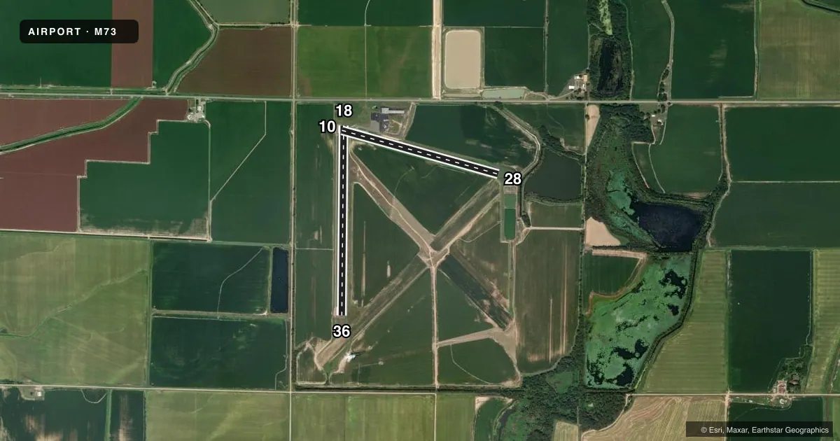
Runways & pattern
Full pagePattern entry · RWY 28
LEFT TRAFFIC| Runway | Heading (°M) | Length | Surface | Traffic |
|---|---|---|---|---|
| 18/36 | 179° / 359° | 3,494 ft | ASPH | Standard L |
| 10/28Favored | 104° / 284° | 3,000 ft | ASPH | Standard L |
Runway end performance
| End | TORA | TODA | ASDA | LDA | VGSI | Approach lights | Obstruction |
|---|---|---|---|---|---|---|---|
| 18 | — | — | — | — | PAPI 2-box right(3°) | — | 15', road, 450' from thr, 0' R of cntrln, slope 16 |
| 36 | — | — | — | — | PAPI 2-box left(3°) | — | — |
| 28 | — | — | — | — | — | — | 20', trees, 540' from thr, 115' R of cntrln, slope 17 |
Declared distances in feet. TORA = takeoff run available, TODA = takeoff distance, ASDA = accelerate-stop, LDA = landing distance.
Airport sketch
Runways drawn to scale from FAA survey coordinates, rendered over satellite imagery. Not for navigation.
Approaches & charts
Services on the field
Fuel grades, oxygen, maintenance, ramp storage and lighting — as declared to the FAA by the airport operator.
Fuel & services
- Fuel
- 100LL
- Oxygen (bottled)
- Not available
- Oxygen (bulk)
- Not available
- Airframe repair
- Minor
- Power plant repair
- Minor
- Other services
- AGRI
Ramp & ground
- Transient storage
- Tie-down
- Landing fee
- No fee published
- Customs
- Not available
- Lighting schedule
- SEE RMK
- Beacon schedule
- SS-SR
- Beacon
- White / Green (civil land)(WG)
- Wind indicator
- Lighted
- Segmented circle
- Yes
Fuel & FBOs
Cheapest 100LL and Jet A on the field and nearby. Always confirm with the FBO before taxi.
Airport notes
Surface conditions, obstructions, local procedures, lighting outages and other notes published with each FAA cycle.
General notes
- MIGRATORY BIRDS ON & INVOF AIRPORT NOV-FEB
- NUMEROUS AGRICULTURAL ACFT OPNS
- FOR CD WHEN UNA VIA FREQ CTC LITTLE ROCK APCH 501-379-2908 OR LITTLE ROCK ATCT 501-379-2911
Lighting notes
- ACTVT MIRL RY 18/36, PAPI RYS 18 & 36 - CTAF.
Fuel notes
- 100LL100 LL SELF SERVE AVBL WITH CREDIT CARD. FOR SVC AFT HRS CALL 870-830-1231.
Runway surface & condition
- 18/36PCR VALUE: 80/F/C/X/T
Approach & departure obstructions
- 1010 FT GRVL ROAD 0 FT FM THLD.
- 18RWY 18 MARKINGS FADED
- 18RWY 18 APCH RATIO FROM DSPLCD THLD 32:1
Other notes
- PRE DATES THE ACT.
VFR map & nearby airports
VFR sectional. Tap any ICAO chip to open that airport.
Key facts · M73
Answer card- ICAO
- M73
- Name
- ALMYRA MUNI
- Location
- ALMYRA, ARKANSAS
- Elevation
- 210.2 ft MSL
- Traffic pattern altitude
- 1,210.2 ft MSL (1,000 AGL)
- Control tower
- Non-towered (use CTAF)
- Total runways
- 2
- Longest runway
- 18/36 · 3,494 ft
- Published ILS approaches
- 0
- Published frequencies
- 5
- Magnetic variation
- 2°
- Current flight rules
- VFR
- Current wind
- 240° at 4 kt
- Favored runway now
- RWY 28
ALMYRA MUNI sits in Almyra, Arkansas. Field elevation is 210.2 ft MSL. The airport has two asphalt runways. The longest is runway 18/36 at 3,494 ft. There is no control tower, so plan for self-announce traffic on CTAF 123.0. No ILS approaches are published here.
Pattern altitude is not published. Use the standard 1,000 ft AGL pattern unless the current FAA Chart Supplement or local traffic calls for something different. The field is in agricultural country, so expect ag aircraft activity. Published remarks also note migratory birds from November through February. That matters on arrival and departure.
Grand Prairie Dusters is on the field. It carries 100LL. Self-serve 100LL is available with credit card. For after-hours service, call the number in the Chart Supplement or the FBO directly. Runway 18 has faded markings. There is also a gravel road close to the threshold of runway 10. Runway 18 has a displaced-threshold approach note, so brief that side before you go in.
This is an uncontrolled airport with Little Rock approach services listed for clearance delivery and approach or departure support. If you need the latest local procedures, check the current FAA Chart Supplement before you launch. The pavement rating on runway 18/36 is published as 80/F/C/X/T.