METAR & TAF 99A
99A does not publish a METAR.
Showing the nearest reporting station: KPBF (PINEBLUFF RGNL/GRIDER FLD) · 14.0 NM away. Conditions at 99A may differ.
METAR · KPBF
Observed 04:53Z
KPBF 270453Z AUTO 23007KT 10SM CLR 29/24 A2994 RMK AO2 SLP133 T02890239 PWINO
- Wind
- 230° @ 7 kt
- Visibility
- 10 SM
- Temp / Dew
- 29°C / 24°C
- Altimeter
- 29.94 inHg
- Clouds
- CLR
- Density alt
- 1,926 ft
- Ceiling
- Unlimited
- Rules
- VFR
Airport info & contacts
Manager on record, flight service, ARTCC, attendance schedule and pattern altitude — published by the FAA and refreshed every 28 days.
Location
- From city
- 1 NM NW
- VFR sectional
- MEMPHIS
- ARTCC
- ZME · MEMPHIS
- NOTAM facility
- JBR (NOTAM-D)
Airport manager
- Name
- BEVERLY A. SMITH
- Phone
- (870) 766-4619
- Address
- 9010 N. HWY 15, SHERRILL AR 72152
Flight service · Hours
- FSS JBR
- JONESBORO1-800-WX-BRIEF
- Attendance
- Unattended
Frequencies
Tap any row to copy the frequency to your clipboard.
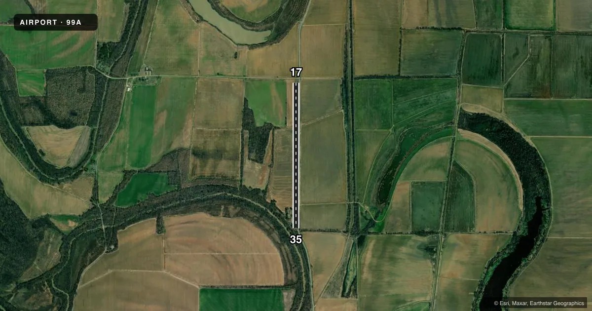
Runways & pattern
Full pagePattern entry · RWY 17
LEFT TRAFFICRunway end performance
| End | TORA | TODA | ASDA | LDA | VGSI | Approach lights | Obstruction |
|---|---|---|---|---|---|---|---|
| 17 | — | — | — | — | — | — | 15', road, 0' from thr, 0' R of cntrln, slope 0 |
| 35 | — | — | — | — | — | — | 50', trees, 0' from thr, slope 0 |
Declared distances in feet. TORA = takeoff run available, TODA = takeoff distance, ASDA = accelerate-stop, LDA = landing distance.
Airport sketch
Runways drawn to scale from FAA survey coordinates, rendered over satellite imagery. Not for navigation.
Approaches & charts
Services on the field
Fuel grades, oxygen, maintenance, ramp storage and lighting — as declared to the FAA by the airport operator.
Fuel & services
- Fuel
- Not available
Ramp & ground
- Transient storage
- Not published
- Wind indicator
- Yes
- Segmented circle
- No
Fuel & FBOs
Cheapest 100LL and Jet A on the field and nearby. Always confirm with the FBO before taxi.
Airport notes
Surface conditions, obstructions, local procedures, lighting outages and other notes published with each FAA cycle.
General notes
- FOR CD CTC LITTLE ROCK APCH 501-379-2908 OR LITTLE ROCK ATCT 501-379-2911.
Other notes
- PRVDD ALL OPNS ARE CONDUCTED IN ACCORDANCE WITH LTR OF AGREEMENT DATED 6/27/91 BTN TOMMY ANDERSON ARPT & SHERRILL FLYING SERVICE ARPT.
VFR map & nearby airports
VFR sectional. Tap any ICAO chip to open that airport.
Key facts · 99A
Answer card- ICAO
- 99A
- Name
- SMITH'S INTL
- Location
- SHERRILL, ARKANSAS
- Elevation
- 218 ft MSL
- Traffic pattern altitude
- 1,218 ft MSL (1,000 AGL)
- Control tower
- Non-towered (use CTAF)
- Total runways
- 1
- Longest runway
- 17/35 · 3,800 ft
- Published ILS approaches
- 0
- Published frequencies
- 1
- Magnetic variation
- 3°
- Current flight rules
- VFR
- Current wind
- 230° at 7 kt
- Favored runway now
- RWY 17
SMITH'S INTL (99A) sits in Sherrill, Arkansas. Field elevation is 218 ft MSL. The airport has one runway. Runway 17/35 is 3,800 ft of turf, so plan for soft-field technique and check the surface before you go. No control tower is listed. CTAF is 122.9.
No ILS approaches are published here. Pattern altitude is not published in the facts, so use standard 1,000 ft AGL for light piston operations unless the current Chart Supplement says otherwise. The field is in a low-elevation area, so density altitude is usually less of a factor than at higher strips, but turf condition and braking action still matter. Published remarks say operations are tied to a letter of agreement dated 6/27/91 between Tommy Anderson Airport and Sherrill Flying Service Airport. For clearance delivery, contact Little Rock Approach or Little Rock Air Traffic Control Tower using the numbers in the current Chart Supplement. If you need current airport details before departure, verify them with the airport operator.