METAR & TAF 9M8
9M8 does not publish a METAR.
Showing the nearest reporting station: KSUZ (SALINE COUNTY RGNL) · 17.0 NM away. Conditions at 9M8 may differ.
METAR · KSUZ
Observed 19:15Z
KSUZ 271915Z AUTO 26010KT 5SM HZ CLR 37/22 A2989 RMK A01
- Wind
- 260° @ 10 kt
- Visibility
- 5 SM
- Temp / Dew
- 37°C / 22°C
- Altimeter
- 29.89 inHg
- Clouds
- CLR
- Density alt
- 2,970 ft
- Ceiling
- Unlimited
- Rules
- MVFR
Airport info & contacts
Manager on record, flight service, ARTCC, attendance schedule and pattern altitude — published by the FAA and refreshed every 28 days.
Location
- From city
- 3 NM E
- VFR sectional
- MEMPHIS
- ARTCC
- ZME · MEMPHIS
- NOTAM facility
- JBR (NOTAM-D)
Airport manager
- Name
- KEVIN RUTHERFORD
- Phone
- 870-941-9595
- Address
- 233 AIRPORT ROAD, SHERIDAN AR 72150
Flight service · Hours
- FSS JBR
- JONESBORO1-800-WX-BRIEF
- Attendance
- Unattended
Frequencies
Tap any row to copy the frequency to your clipboard.
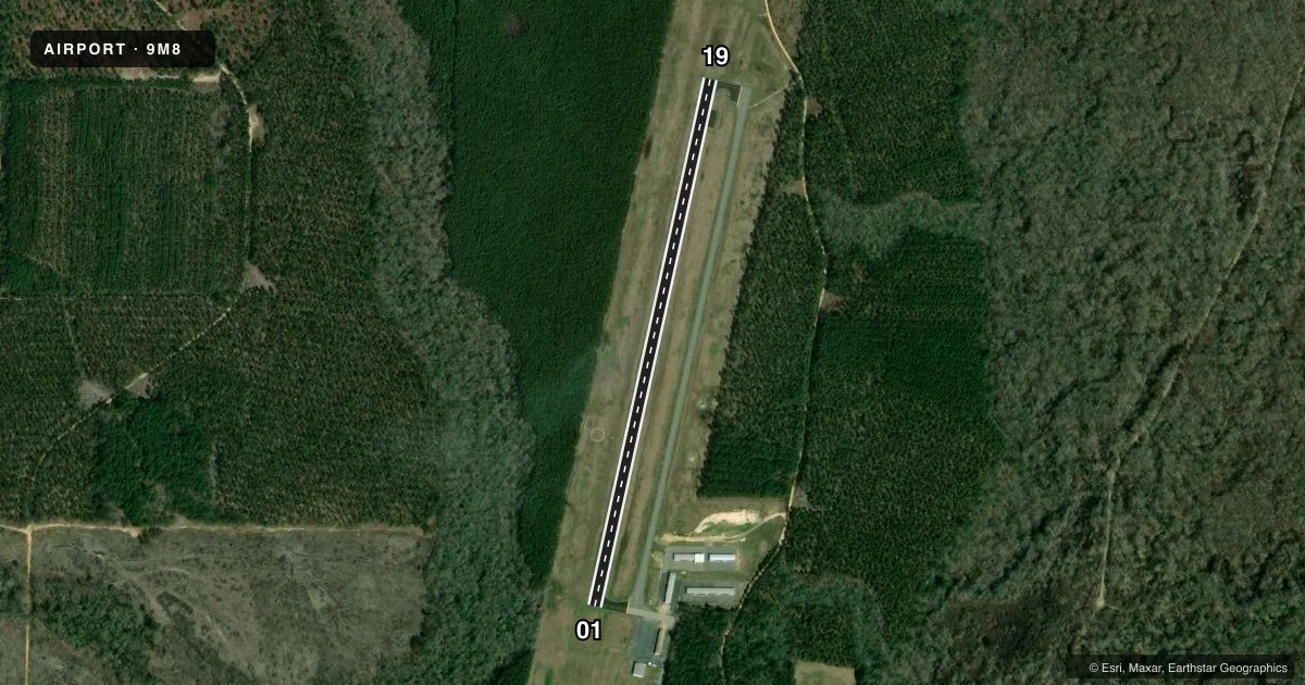
Runways & pattern
Full pagePattern entry · RWY 19
LEFT TRAFFICRunway end performance
| End | TORA | TODA | ASDA | LDA | VGSI | Approach lights | Obstruction |
|---|---|---|---|---|---|---|---|
| 01 | — | — | — | — | PAPI 2-box left(3.75°) | — | 60', trees, 1500' from thr, 0' R of cntrln, slope 21 |
| 19 | — | — | — | — | PAPI 2-box left(3.25°) | — | 30', trees, 1350' from thr, 0' R of cntrln, slope 38 |
Declared distances in feet. TORA = takeoff run available, TODA = takeoff distance, ASDA = accelerate-stop, LDA = landing distance.
Airport sketch
Runways drawn to scale from FAA survey coordinates, rendered over satellite imagery. Not for navigation.
Approaches & charts
Services on the field
Fuel grades, oxygen, maintenance, ramp storage and lighting — as declared to the FAA by the airport operator.
Fuel & services
- Fuel
- 100LL
- Airframe repair
- Not available
- Power plant repair
- Not available
Ramp & ground
- Transient storage
- Tie-down
- Landing fee
- No fee published
- Lighting schedule
- SEE RMK
- Beacon schedule
- SS-SR
- Beacon
- White / Green (civil land)(WG)
- Wind indicator
- Lighted
- Segmented circle
- Yes
Fuel & FBOs
Cheapest 100LL and Jet A on the field and nearby. Always confirm with the FBO before taxi.
Airport notes
Surface conditions, obstructions, local procedures, lighting outages and other notes published with each FAA cycle.
General notes
- FOR CD CTC LITTLE ROCK APCH 501-379-2908 OR LITTLE ROCK ATCT 501-379-2911.
Lighting notes
- ACTVT PAPI RWYS 01 & 19; MIRL RWY 01/19 - CTAF.
Fuel notes
- 100LLSELF SERVICE FUEL AVBL 24 HRS WITH CREDIT CARD.
Approach & departure obstructions
- 01RWY 01 PAPI UNUSBL BYD 6 DEG LEFT OF CNTRLN.
VFR map & nearby airports
VFR sectional. Tap any ICAO chip to open that airport.
Key facts · 9M8
Answer card- ICAO
- 9M8
- Name
- SHERIDAN-GRANT COUNTY RGNL
- Location
- SHERIDAN, ARKANSAS
- Elevation
- 236 ft MSL
- Traffic pattern altitude
- 1,236 ft MSL (1,000 AGL)
- Control tower
- Non-towered (use CTAF)
- Total runways
- 1
- Longest runway
- 01/19 · 3,202 ft
- Published ILS approaches
- 0
- Published frequencies
- 4
- Magnetic variation
- 0°
- Current flight rules
- MVFR
- Current wind
- 260° at 10 kt
- Favored runway now
- RWY 19
Sheridan-Grant County Rgnl Airport sits in Sheridan, Arkansas. Field elevation is 236 ft MSL. The airport has one runway. Runway 01/19 is 3,202 ft long with an asphalt surface. There is no control tower. CTAF and UNICOM are both 122.8. Little Rock Approach handles approach and departure services on 135.4 and 353.6.
No ILS approaches are published here. Pattern altitude is not published in the facts, so use the standard 1,000 ft AGL for light piston operations unless the current Chart Supplement says otherwise. The on-field FBO is Sheridan-Grant County Airport. It carries AVGAS 100LL. Self-service fuel is available 24 hours with credit card.
A few operational notes matter here. PAPI is activated for runways 01 and 19. The runway lights are medium intensity and are activated on CTAF. The published remarks also say the runway 01 PAPI is unusable beyond 6 degrees left of centerline. That is worth keeping in mind on final to 01. If you need clearance delivery, contact Little Rock Approach at 501-379-2908 or Little Rock Tower at 501-379-2911. For any current noise, curfew, or other local restrictions, check the current FAA Chart Supplement before you go.