METAR & TAF KSUZ
Current METAR
Observed 18:15Z
KSUZ 271815Z AUTO 22008KT 6SM HZ CLR 36/21 A2992 RMK A01
- Wind
- 220° @ 8 kt
- Visibility
- 6 SM
- Temp / Dew
- 36°C / 21°C
- Altimeter
- 29.92 inHg
- Clouds
- CLR
- Density alt
- 3,003 ft
- Ceiling
- Unlimited
- Rules
- VFR
Airport info & contacts
Manager on record, flight service, ARTCC, attendance schedule and pattern altitude — published by the FAA and refreshed every 28 days.
Location
- From city
- 5 NM E
- VFR sectional
- MEMPHIS
- ARTCC
- ZME · MEMPHIS
- NOTAM facility
- JBR (NOTAM-D)
Airport manager
- Name
- AJ AMBORT
- Phone
- (501) 672-9809
- Address
- 1100 HILL FARM ROAD, BRYANT AR 72022
Flight service · Hours
- FSS JBR
- JONESBORO1-800-WX-BRIEF
- Attendance
- MON-FRI · 0800-1630
Frequencies
Tap any row to copy the frequency to your clipboard.
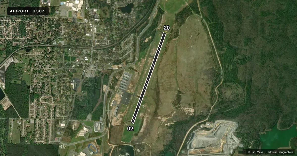
Runways & pattern
Full pagePattern entry · RWY 20
LEFT TRAFFICRunway end performance
| End | TORA | TODA | ASDA | LDA | VGSI | Approach lights | Obstruction |
|---|---|---|---|---|---|---|---|
| 02 | — | — | — | — | PAPI 4-box left(3°) | — | 38', trees, 1650' from thr, 0' R of cntrln, slope 38 |
| 20 | — | — | — | — | PAPI 4-box left(3°) | — | 30', tree, 980' from thr, 575' R of cntrln, slope 26 |
Declared distances in feet. TORA = takeoff run available, TODA = takeoff distance, ASDA = accelerate-stop, LDA = landing distance.
Airport sketch
Runways drawn to scale from FAA survey coordinates, rendered over satellite imagery. Not for navigation.
Approaches & charts
ILS · 1
Services on the field
Fuel grades, oxygen, maintenance, ramp storage and lighting — as declared to the FAA by the airport operator.
Fuel & services
- Fuel
- 100LLA+
- Airframe repair
- Minor
- Power plant repair
- Major
- Other services
- INSTR,RNTL
Ramp & ground
- Transient storage
- Tie-down
- Lighting schedule
- SEE RMK
- Beacon schedule
- SS-SR
- Beacon
- White / Green (civil land)(WG)
- Wind indicator
- Lighted
- Segmented circle
- Yes
Fuel & FBOs
Cheapest 100LL and Jet A on the field and nearby. Always confirm with the FBO before taxi.
Airport notes
Surface conditions, obstructions, local procedures, lighting outages and other notes published with each FAA cycle.
General notes
- COURTESY CAR AVBL. AFT HRS, CTC AMGR FOR TRML BLDG ENTRY CODE.
- FOR CD CTC LITTLE ROCK APCH 501-379-2908 OR LITTLE ROCK ATCT 501-379-2911.
Lighting notes
- ACTVT REIL RWYS 02 & 20; MIRL RWY 02/20 - CTAF.
Fuel notes
- 100LLSELF SVC FUEL AVBL 24 HRS WITH CREDIT CARD.
Other notes
- PRVDD RY ORIENTATION IS 02/20; STANDARD TFC PAT IS TO THE WEST; POST SIGNAGE WITH PILOT INFO; COORDINATE IAPS WITH LITTLE ROCK ATCT; OBTAIN FUTURE WAAS; INSTALL NEW RCO; INSTALL AWOS OR ASOS; PROMOTE PILOT SAFETY PROGRAM.
- 1SELF SERVE 100LL & JET A AVBL 24/7, FOR SVC AFTER HOURS CALL 501-672-9809 CALL OUT FEE
VFR map & nearby airports
VFR sectional. Tap any ICAO chip to open that airport.
Key facts · KSUZ
Answer card- ICAO
- KSUZ
- Name
- SALINE COUNTY RGNL
- Location
- BENTON, ARKANSAS
- Elevation
- 389.4 ft MSL
- Traffic pattern altitude
- 1,389.4 ft MSL (1,000 AGL)
- Control tower
- Non-towered (use CTAF)
- Total runways
- 1
- Longest runway
- 02/20 · 5,002 ft
- Published ILS approaches
- 1
- Published frequencies
- 4
- Magnetic variation
- 1°
- Current flight rules
- VFR
- Current wind
- 220° at 8 kt
- Favored runway now
- RWY 20
Saline County Regional Airport sits in Benton, Arkansas. Field elevation is 389.4 ft MSL. The airport has one runway. Runway 02/20 is 5,002 ft long with asphalt pavement. There is no control tower. The published traffic pattern is not listed, so use the current Chart Supplement and coordinate as needed. For light piston traffic, plan on the standard 1,000 ft AGL pattern unless local procedures say otherwise.
KSUZ has one ILS approach, published for runway 02. Approach and departure services are handled by Little Rock on 119.5 and 306.2. CTAF and UNICOM are both 122.8. The on-field FBO is Saline County Regional Airport. It carries 100LL and Jet A. Self-serve fuel is available 24 hours a day with a credit card. After hours, call the airport number if you need fuel service. A courtesy car is also available.
For lighting, runway end identifier lights are on runways 02 and 20. Medium intensity runway lights are on 02/20 and are controlled by CTAF. The standard traffic pattern is to the west. If you are new to the field, pay attention to the runway lighting setup and the instrument approach coordination with Little Rock ATC. The airport is close enough to the Little Rock area that you should be ready for controlled-airspace procedures and normal radio discipline.