METAR & TAF KHOT
Current METAR
Observed 12:53Z
KHOT 271253Z AUTO 00000KT 10SM CLR 28/22 A2998 RMK AO2 SLP143 T02830222
- Wind
- 000° @ 0 kt
- Visibility
- 10 SM
- Temp / Dew
- 28°C / 22°C
- Altimeter
- 29.98 inHg
- Clouds
- CLR
- Density alt
- 2,156 ft
- Ceiling
- Unlimited
- Rules
- VFR
Airport info & contacts
Manager on record, flight service, ARTCC, attendance schedule and pattern altitude — published by the FAA and refreshed every 28 days.
Location
- From city
- 3 NM SW
- VFR sectional
- MEMPHIS
- ARTCC
- ZME · MEMPHIS
- NOTAM facility
- HOT (NOTAM-D)
Airport manager
- Name
- DON ROWLETT
- Phone
- 501-321-6750
- Address
- 525 AIRPORT ROAD, HOT SPRINGS AR 71913
Flight service · Hours
- FSS JBR
- JONESBORO1-800-WX-BRIEF
- Attendance
- 0500-2200
Frequencies
Tap any row to copy the frequency to your clipboard.
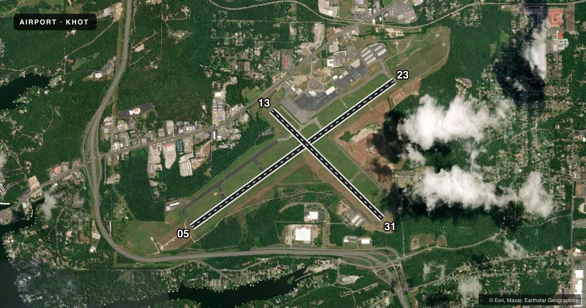
Runways & pattern
Full pagePattern entry · RWY 05
RIGHT TRAFFIC| Runway | Heading (°M) | Length | Surface | Traffic |
|---|---|---|---|---|
| 05/23 | 53° / 233° | 6,595 ft | ASPH | 05 R |
| 13/31 | 133° / 313° | 4,098 ft | ASPH | 13 R |
Runway end performance
| End | TORA | TODA | ASDA | LDA | VGSI | Approach lights | Obstruction |
|---|---|---|---|---|---|---|---|
| 05 | 6,595' | 6,595' | 6,595' | 6,595' | — | MALSR | — |
| 23 | 6,595' | 6,595' | 6,235' | 6,235' | PAPI 4-box left(3°) | — | 78', pole, 1800' from thr, 650' R of cntrln, slope 20 |
| 13 | 3,210' | 4,098' | 4,098' | 4,098' | — | — | 40', trees, 600' from thr, 150' R of cntrln, slope 10 |
| 31 | 4,098' | 4,098' | 4,098' | 3,210' | — | — | 121', pole, 3200' from thr, 300' R of cntrln, slope 24 |
Declared distances in feet. TORA = takeoff run available, TODA = takeoff distance, ASDA = accelerate-stop, LDA = landing distance.
Airport sketch
Runways drawn to scale from FAA survey coordinates, rendered over satellite imagery. Not for navigation.
Approaches & charts
ILS · 1
Services on the field
Fuel grades, oxygen, maintenance, ramp storage and lighting — as declared to the FAA by the airport operator.
Fuel & services
- Fuel
- 100LLA
- Oxygen (bottled)
- Not available
- Oxygen (bulk)
- Not available
- Airframe repair
- Major
- Power plant repair
- Major
- Other services
- AFRT,AMB,AVNCS,CHTR,INSTR,RNTL,SALES
Ramp & ground
- Transient storage
- Tie-down
- Hangar
- Landing fee
- No fee published
- Customs
- Not available
- Lighting schedule
- SEE RMK
- Beacon schedule
- SS-SR
- Beacon
- White / Green (civil land)(WG)
- Wind indicator
- Lighted
- Segmented circle
- Yes
Fuel & FBOs
Cheapest 100LL and Jet A on the field and nearby. Always confirm with the FBO before taxi.
Airport notes
Surface conditions, obstructions, local procedures, lighting outages and other notes published with each FAA cycle.
General notes
- FOR CD CTC MEMPHIS ARTCC AT 901-368-8453.
Lighting notes
- ACTVT HIRL RY 05/23; MIRL RY 13/31; MALSR RY 05; PAPI RY 23 & REIL RY 13 - CTAF.
Fuel notes
- 100LLFOR FUEL AFT HRS CALL 501-617-0324.
Runway surface & condition
- 05/23PCR VALUE: 370/F/B/X/U
- 13/31PCR VALUE: 28/F/B/Y/U
Approach & departure obstructions
- 23RWY 23 PAPI UNUSBL BYD 6 DEGS RIGHT OF CNTRLN.
VFR map & nearby airports
VFR sectional. Tap any ICAO chip to open that airport.
Key facts · KHOT
Answer card- ICAO
- KHOT
- Name
- MEML FLD
- Location
- HOT SPRINGS, ARKANSAS
- Elevation
- 540.3 ft MSL
- Traffic pattern altitude
- 1,540.3 ft MSL (1,000 AGL)
- Control tower
- Non-towered (use CTAF)
- Total runways
- 2
- Longest runway
- 05/23 · 6,595 ft
- Published ILS approaches
- 1
- Published frequencies
- 2
- Magnetic variation
- 1°
- Current flight rules
- VFR
- Current wind
- 000° at 0 kt
- Favored runway now
- –
MEML FLD is in Hot Springs, Arkansas. Field elevation is 540.3 ft MSL. The airport has two asphalt runways. The longest is runway 05/23 at 6,595 ft. This is an uncontrolled field. CTAF and UNICOM are both 123.0. Pattern altitude is not published, so use the standard 1,000 ft AGL for light piston traffic unless the current Chart Supplement says otherwise.
There is one ILS approach on runway 05. That matters here because runway 05 also has medium intensity approach lighting with runway alignment indicator lights. Runway 05/23 has high intensity runway lights. Runway 13/31 has medium intensity runway lights. The published remarks also note that the PAPI on runway 23 is unusable beyond 6 degrees right of centerline. Keep that in mind if you are planning a visual to 23.
Hot Springs Memorial Field is the on-field FBO. It carries 100LL and Jet A. For fuel after hours, the published remark gives a phone number to call. Clearance delivery is handled through Memphis ARTCC. If you need that service, verify the current procedure before departure. With two runways and a published ILS, this is a practical stop for piston and turbine traffic. Still brief the lighting, runway 23 PAPI note and current remarks before arrival.