METAR & TAF 7M3
7M3 does not publish a METAR.
Showing the nearest reporting station: KHOT (MEML FLD) · 21.7 NM away. Conditions at 7M3 may differ.
METAR · KHOT
Observed 11:53Z
KHOT 271153Z AUTO 00000KT 5SM HZ CLR 26/22 A2996 RMK AO2 SLP138 T02610222 10294 20250 53010
- Wind
- 000° @ 0 kt
- Visibility
- 5 SM
- Temp / Dew
- 26°C / 22°C
- Altimeter
- 29.96 inHg
- Clouds
- CLR
- Density alt
- 2,069 ft
- Ceiling
- Unlimited
- Rules
- MVFR
Airport info & contacts
Manager on record, flight service, ARTCC, attendance schedule and pattern altitude — published by the FAA and refreshed every 28 days.
Location
- From city
- 5 NM E
- VFR sectional
- MEMPHIS
- ARTCC
- ZME · MEMPHIS
- NOTAM facility
- JBR (NOTAM-D)
Airport manager
- Name
- LEON TURNAGE
- Phone
- 817-999-3310
- Address
- P.O. BOX 631, WEATHERFORD TX 76086
Flight service · Hours
- FSS JBR
- JONESBORO1-800-WX-BRIEF
- Attendance
- Unattended
Frequencies
Tap any row to copy the frequency to your clipboard.
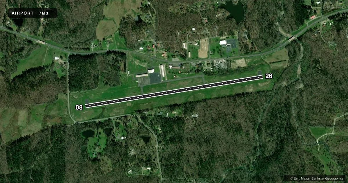
Runways & pattern
Full pagePattern entry · RWY 08
LEFT TRAFFICRunway end performance
| End | TORA | TODA | ASDA | LDA | VGSI | Approach lights | Obstruction |
|---|---|---|---|---|---|---|---|
| 08 | — | — | — | — | PAPI 2-box right(4°) | — | 70', tree, 1300' from thr, 135' R of cntrln, slope 15 |
| 26 | — | — | — | — | PAPI 2-box right(4°) | — | 38', trees, 470' from thr, 55' R of cntrln, slope 7 |
Declared distances in feet. TORA = takeoff run available, TODA = takeoff distance, ASDA = accelerate-stop, LDA = landing distance.
Airport sketch
Runways drawn to scale from FAA survey coordinates, rendered over satellite imagery. Not for navigation.
Approaches & charts
Services on the field
Fuel grades, oxygen, maintenance, ramp storage and lighting — as declared to the FAA by the airport operator.
Fuel & services
- Fuel
- 100LLA
- Oxygen (bottled)
- Not available
- Oxygen (bulk)
- Not available
Ramp & ground
- Transient storage
- Tie-down
- Hangar
- Landing fee
- No fee published
- Customs
- Not available
- Lighting schedule
- SEE RMK
- Beacon schedule
- SS-SR
- Beacon
- White / Green (civil land)(WG)
- Wind indicator
- Lighted
- Segmented circle
- No
Fuel & FBOs
Cheapest 100LL and Jet A on the field and nearby. Always confirm with the FBO before taxi.
Airport notes
Surface conditions, obstructions, local procedures, lighting outages and other notes published with each FAA cycle.
General notes
- DEER & COYOTES ON & INVOF ARPT
- FOR CD CTC MEMPHIS ARTCC AT 901-368-8453/8449.
Lighting notes
- ACTVT PAPI RWY 08 & RWY 26; MIRL RWY 08/26 - CTAF.
Fuel notes
- 100LLSELF SERVICE FUEL AVBL 24 HRS WITH CREDIT CARD (JET A & 100LL)
Approach & departure obstructions
- 08PAPI UNUSBL BYD 8 DEGS LEFT AND BYD 5 DEGS RIGHT OF CNTRLN.
- 26PAPI UNUSBL BYD 8 DEGS RIGHT OF CNTRLN.
- 26APCH SLOPE 17:1 TO DSPLCD THLD.
Other notes
- MANAGER100LL/JET A AVBL 24/7 CALL 817-999-4479 OR 817-999-3310 FOR SERV
VFR map & nearby airports
VFR sectional. Tap any ICAO chip to open that airport.
Key facts · 7M3
Answer card- ICAO
- 7M3
- Name
- BEARCE
- Location
- MOUNT IDA, ARKANSAS
- Elevation
- 644.4 ft MSL
- Traffic pattern altitude
- 1,644.4 ft MSL (1,000 AGL)
- Control tower
- Non-towered (use CTAF)
- Total runways
- 1
- Longest runway
- 08/26 · 4,000 ft
- Published ILS approaches
- 0
- Published frequencies
- 1
- Magnetic variation
- 5°
- Current flight rules
- MVFR
- Current wind
- 000° at 0 kt
- Favored runway now
- –
BEARCE is in Mount Ida, Arkansas. The field elevation is 644.4 ft MSL. It has one runway. Runway 08/26 is 4,000 ft of asphalt, which is the longest runway on the field. There is no control tower, so plan for CTAF operations on 122.9.
No ILS approaches are published here. The published pattern altitude is not listed, so use the standard 1,000 ft AGL for light piston traffic unless the current FAA Chart Supplement says otherwise. The airport sits in a rural area, so watch for deer and coyotes on or near the movement area. That matters here more than it would at a busier field.
Turnage Farms is on the field. It carries AVGAS 100LL, Jet A and Jet A Prist. Fuel is available 24 hours a day with self-service credit card access for 100LL and Jet A. The published remarks also note that runway 08 and 26 PAPI and the medium intensity runway lights are activated on CTAF. For runway 26, the approach slope to the displaced threshold is steep. The PAPI is unusable well right of centerline. For runway 08, the PAPI is unusable well left and right of centerline. If you need clearance delivery, contact Memphis ARTCC before departure.