METAR & TAF 5M4
5M4 does not publish a METAR.
Showing the nearest reporting station: KCDH (HARRELL FLD) · 24.0 NM away. Conditions at 5M4 may differ.
METAR · KCDH
Observed 16:35Z
KCDH 271635Z AUTO 30009KT 10SM CLR 33/23 A2996 RMK AO2 T03330231 $
- Wind
- 300° @ 9 kt
- Visibility
- 10 SM
- Temp / Dew
- 33°C / 23°C
- Altimeter
- 29.96 inHg
- Clouds
- CLR
- Density alt
- 2,350 ft
- Ceiling
- Unlimited
- Rules
- VFR
Airport info & contacts
Manager on record, flight service, ARTCC, attendance schedule and pattern altitude — published by the FAA and refreshed every 28 days.
Location
- From city
- 3 NM NE
- VFR sectional
- MEMPHIS
- ARTCC
- ZME · MEMPHIS
- NOTAM facility
- JBR (NOTAM-D)
Airport manager
- Name
- JAMES H SMITH
- Phone
- 870-313-2870
- Address
- PO BOX 132, FORDYCE AR 71742
Flight service · Hours
- FSS JBR
- JONESBORO1-800-WX-BRIEF
- Attendance
- Unattended
Frequencies
Tap any row to copy the frequency to your clipboard.
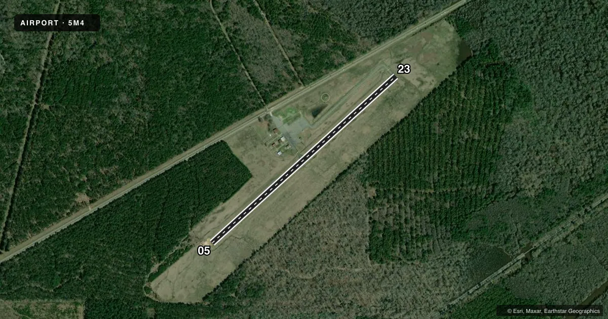
Runways & pattern
Full pagePattern entry · RWY 23
LEFT TRAFFICRunway end performance
| End | TORA | TODA | ASDA | LDA | VGSI | Approach lights | Obstruction |
|---|---|---|---|---|---|---|---|
| 05 | — | — | — | — | — | — | 60', trees, 1100' from thr, 0' R of cntrln, slope 15 |
| 23 | — | — | — | — | — | — | 65', trees, 850' from thr, 315' R of cntrln, slope 10 |
Declared distances in feet. TORA = takeoff run available, TODA = takeoff distance, ASDA = accelerate-stop, LDA = landing distance.
Airport sketch
Runways drawn to scale from FAA survey coordinates, rendered over satellite imagery. Not for navigation.
Approaches & charts
Services on the field
Fuel grades, oxygen, maintenance, ramp storage and lighting — as declared to the FAA by the airport operator.
Fuel & services
- Fuel
- 100LL
- Oxygen (bottled)
- Not available
- Oxygen (bulk)
- Not available
- Airframe repair
- Not available
- Power plant repair
- Not available
Ramp & ground
- Transient storage
- Tie-down
- Landing fee
- No fee published
- Customs
- Not available
- Lighting schedule
- SEE RMK
- Beacon schedule
- SEE RMK
- Beacon
- White / Green (civil land)(WG)
- Wind indicator
- Lighted
- Segmented circle
- Yes
Fuel & FBOs
Cheapest 100LL and Jet A on the field and nearby. Always confirm with the FBO before taxi.
Airport notes
Surface conditions, obstructions, local procedures, lighting outages and other notes published with each FAA cycle.
General notes
- DEER & MIGRATORY BIRDS ON & INVOF ARPT.
- FOR CD CTC MEMPHIS ARTCC AT 901-368-8453/8449.
Lighting notes
- BCN OPRS DUSK-0100.
- RWY 05/23 MIRL OPRS DUSK-0100.
Fuel notes
- 100LLFUEL AVBL 24 HR SELF SERVICE WITH CREDIT CARD.
VFR map & nearby airports
VFR sectional. Tap any ICAO chip to open that airport.
Key facts · 5M4
Answer card- ICAO
- 5M4
- Name
- FORDYCE MUNI
- Location
- FORDYCE, ARKANSAS
- Elevation
- 193 ft MSL
- Traffic pattern altitude
- 1,193 ft MSL (1,000 AGL)
- Control tower
- Non-towered (use CTAF)
- Total runways
- 1
- Longest runway
- 05/23 · 3,183 ft
- Published ILS approaches
- 0
- Published frequencies
- 1
- Magnetic variation
- 4°
- Current flight rules
- VFR
- Current wind
- 300° at 9 kt
- Favored runway now
- RWY 23
Fordyce Muni sits in Fordyce, Arkansas. Field elevation is 193 ft MSL. The airport has one runway. Runway 05/23 is 3,183 ft long with an asphalt surface. There is no control tower. CTAF is 122.9.
No ILS approaches are published here. Pattern altitude is not published, so use the current Chart Supplement before you go. For light piston traffic, the usual starting point is 1,000 ft AGL unless local guidance says otherwise.
The on-field FBO is Fordyce Municipal Airport. Fuel grades are not reported in the facts block. Published remarks say 100LL is available 24 hours self service with credit card. The beacon and runway lights operate from dusk to 0100. Deer and migratory birds are reported on and near the airport, so keep a sharp scan on arrival and departure. Clearance delivery is handled through Memphis ARTCC by phone when needed. For any current procedure, check the current FAA Chart Supplement or call the airport operator or the FBO directly by phone.