METAR & TAF 0M0
0M0 does not publish a METAR.
Showing the nearest reporting station: KLLQ (MONTICELLO MUNI/ELLIS FLD) · 18.3 NM away. Conditions at 0M0 may differ.
METAR · KLLQ
Observed 15:53Z
KLLQ 271553Z AUTO 26008KT 10SM CLR 34/21 A2996 RMK AO2 SLP141 T03440211
- Wind
- 260° @ 8 kt
- Visibility
- 10 SM
- Temp / Dew
- 34°C / 21°C
- Altimeter
- 29.96 inHg
- Clouds
- CLR
- Density alt
- 2,434 ft
- Ceiling
- Unlimited
- Rules
- VFR
Airport info & contacts
Manager on record, flight service, ARTCC, attendance schedule and pattern altitude — published by the FAA and refreshed every 28 days.
Location
- From city
- 2 NM W
- VFR sectional
- MEMPHIS
- ARTCC
- ZME · MEMPHIS
- NOTAM facility
- JBR (NOTAM-D)
Airport manager
- Name
- BRANNON WEST
- Phone
- 870-382-2216
- Address
- 202 BURNS RD, DUMAS AR 71639
Flight service · Hours
- FSS JBR
- JONESBORO1-800-WX-BRIEF
- Attendance
- MON-FRI · 0800-1700
Frequencies
Tap any row to copy the frequency to your clipboard.
Runways & pattern
Full pagePattern entry · RWY 18
LEFT TRAFFICRunway end performance
| End | TORA | TODA | ASDA | LDA | VGSI | Approach lights | Obstruction |
|---|---|---|---|---|---|---|---|
| 36 | — | — | — | — | PAPI 2-box left(3°) | — | — |
Declared distances in feet. TORA = takeoff run available, TODA = takeoff distance, ASDA = accelerate-stop, LDA = landing distance.
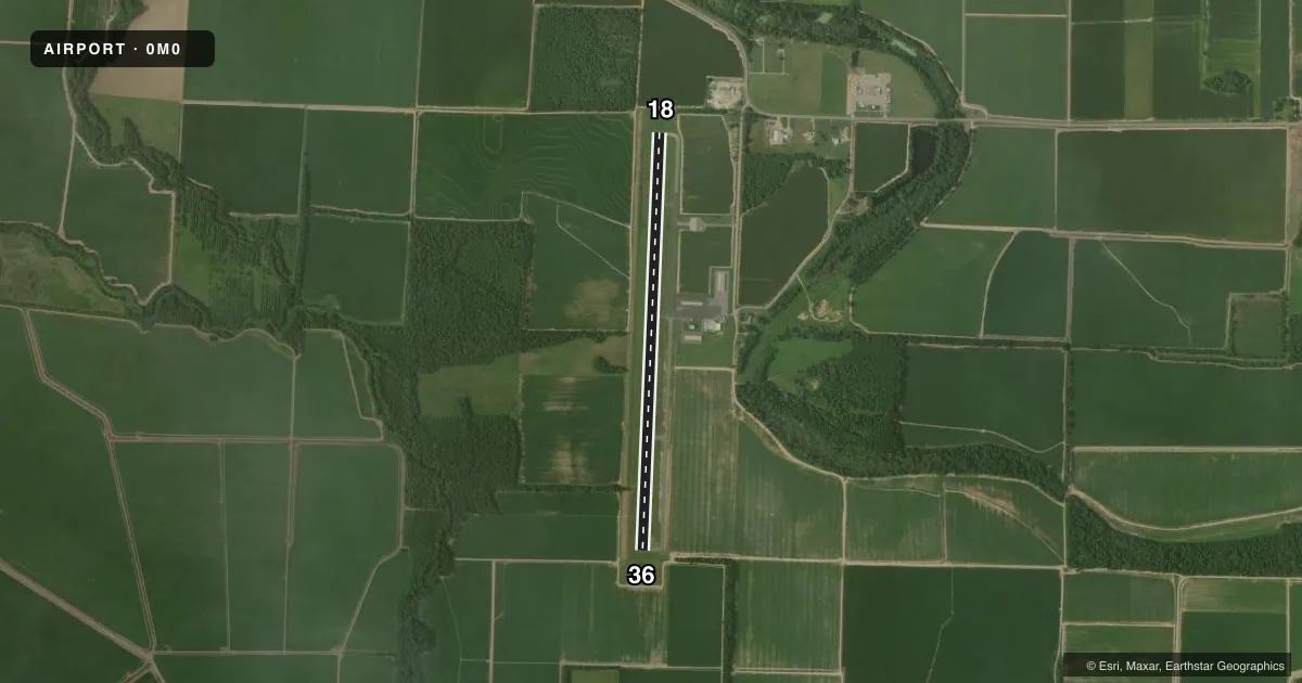
Airport sketch
Runways drawn to scale from FAA survey coordinates, rendered over satellite imagery. Not for navigation.
Approaches & charts
Services on the field
Fuel grades, oxygen, maintenance, ramp storage and lighting — as declared to the FAA by the airport operator.
Fuel & services
- Fuel
- 100LLA
- Airframe repair
- Major
- Power plant repair
- Major
- Other services
- AGRI
Ramp & ground
- Transient storage
- Tie-down
- Hangar
- Landing fee
- No fee published
- Lighting schedule
- SEE RMK
- Beacon schedule
- SS-SR
- Beacon
- White / Green (civil land)(WG)
- Wind indicator
- Lighted
- Segmented circle
- Yes
Fuel & FBOs
Cheapest 100LL and Jet A on the field and nearby. Always confirm with the FBO before taxi.
Airport notes
Surface conditions, obstructions, local procedures, lighting outages and other notes published with each FAA cycle.
General notes
- MIGRATORY BIRDS ON AND INVOF ARPT NOV-FEB.
- FOR CD CTC MEMPHIS ARTCC AT 901-368-8453/8449.
Lighting notes
- BCN TEMP OTS
- ACTVT PAPI RWY 36; MIRL RWY 18/36 - CTAF.
Fuel notes
- 100LLSELF SVC FUEL AVBL 24 HRS WITH CREDIT CARD (100LL & JET A)
Other notes
- 1FOR ARPT ATTENDANT AFT HRS CALL 870-299-3861.
VFR map & nearby airports
VFR sectional. Tap any ICAO chip to open that airport.
Key facts · 0M0
Answer card- ICAO
- 0M0
- Name
- BILLY FREE MUNI
- Location
- DUMAS, ARKANSAS
- Elevation
- 164.2 ft MSL
- Traffic pattern altitude
- 1,164.2 ft MSL (1,000 AGL)
- Control tower
- Non-towered (use CTAF)
- Total runways
- 1
- Longest runway
- 18/36 · 5,003 ft
- Published ILS approaches
- 0
- Published frequencies
- 2
- Magnetic variation
- 1°
- Current flight rules
- VFR
- Current wind
- 260° at 8 kt
- Favored runway now
- RWY 18
Billy Free Muni is in Dumas, Arkansas. The field elevation is 164.2 ft MSL. It has one runway, 18/36, at 5,003 ft. There is no control tower. CTAF and UNICOM are both 122.8. No ILS approaches are published here, so plan with the current chart and your normal nonprecision setup.
The published pattern altitude is not listed. Use 1,000 ft AGL for light piston traffic unless local procedures or the current Chart Supplement say otherwise. Runway 36 has a PAPI. Medium intensity runway lights are available on 18 and 36. The airport beacon is temporarily out of service.
J. B. West Aviation is on the field. It carries 100LL and Jet A Prist. Self-serve fuel is available 24 hours with a credit card. If you need the airport attendant after hours, call the number in the Chart Supplement. Memphis ARTCC handles clearance delivery by phone.
Watch for migratory birds from November through February. That matters here, especially on arrival and departure. The runway is long enough for a lot of piston and light turbine traffic. Still, this is an uncontrolled field, so make your calls early and keep an eye out for traffic on 122.8.