METAR & TAF 4M5
4M5 does not publish a METAR.
Showing the nearest reporting station: KLLQ (MONTICELLO MUNI/ELLIS FLD) · 17.9 NM away. Conditions at 4M5 may differ.
METAR · KLLQ
Observed 04:53Z
KLLQ 270453Z AUTO 24006KT 10SM CLR 29/23 A2995 RMK AO2 SLP139 T02940233
- Wind
- 240° @ 6 kt
- Visibility
- 10 SM
- Temp / Dew
- 29°C / 23°C
- Altimeter
- 29.95 inHg
- Clouds
- CLR
- Density alt
- 1,810 ft
- Ceiling
- Unlimited
- Rules
- VFR
Airport info & contacts
Manager on record, flight service, ARTCC, attendance schedule and pattern altitude — published by the FAA and refreshed every 28 days.
Location
- From city
- 3 NM SW
- VFR sectional
- MEMPHIS
- ARTCC
- ZME · MEMPHIS
- NOTAM facility
- JBR (NOTAM-D)
Airport manager
- Name
- PHILLIP BAUGH
- Phone
- 870-866-5203
- Address
- 2509 HWY 165 S, DERMOTT AR 71638
Flight service · Hours
- FSS JBR
- JONESBORO1-800-WX-BRIEF
- Attendance
- UNATTENDED
Frequencies
Tap any row to copy the frequency to your clipboard.
Runways & pattern
Full pagePattern entry · RWY 19
LEFT TRAFFICRunway end performance
| End | TORA | TODA | ASDA | LDA | VGSI | Approach lights | Obstruction |
|---|---|---|---|---|---|---|---|
| 01 | — | — | — | — | — | — | 15', tree, 240' from thr, 100' R of cntrln, slope 2 |
Declared distances in feet. TORA = takeoff run available, TODA = takeoff distance, ASDA = accelerate-stop, LDA = landing distance.
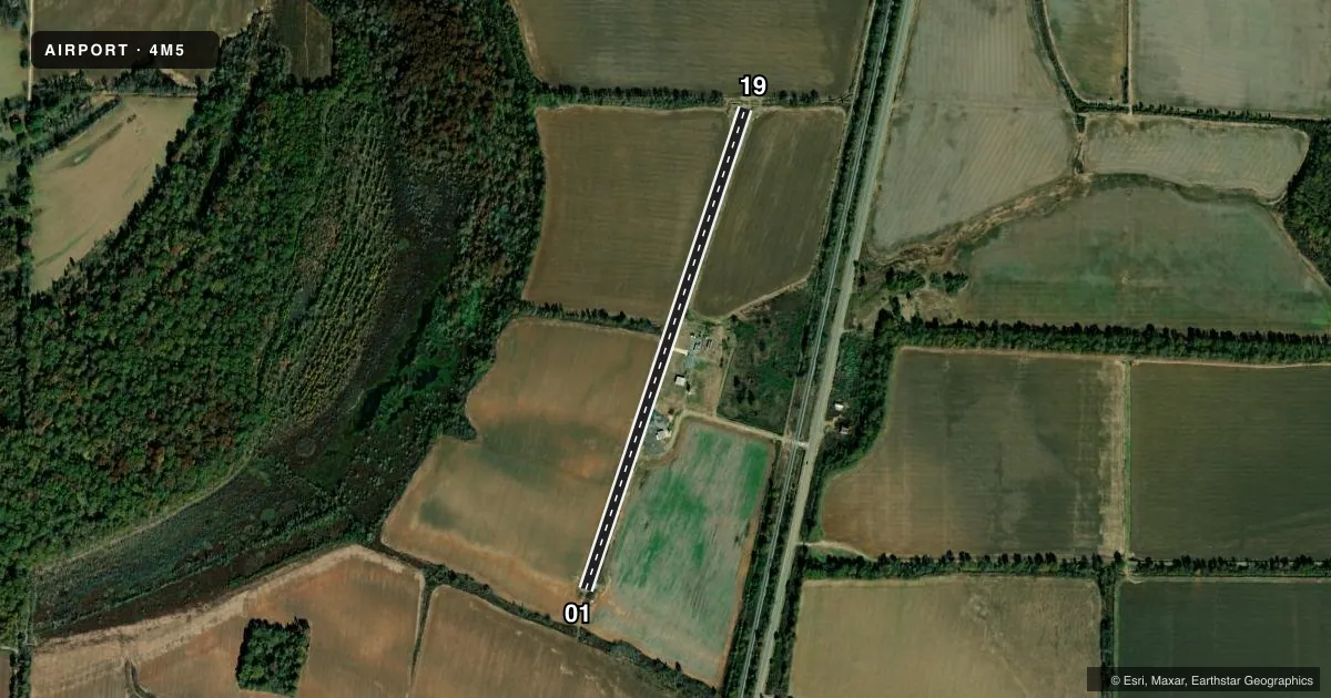
Airport sketch
Runways drawn to scale from FAA survey coordinates, rendered over satellite imagery. Not for navigation.
Approaches & charts
Services on the field
Fuel grades, oxygen, maintenance, ramp storage and lighting — as declared to the FAA by the airport operator.
Fuel & services
- Fuel
- Not available
- Oxygen (bottled)
- Not available
- Oxygen (bulk)
- Not available
- Airframe repair
- Not available
- Power plant repair
- Not available
- Other services
- AGRI
Ramp & ground
- Transient storage
- Tie-down
- Landing fee
- No fee published
- Beacon schedule
- SS-SR
- Beacon
- White / Green (civil land)(WG)
- Wind indicator
- Yes
- Segmented circle
- No
Fuel & FBOs
Cheapest 100LL and Jet A on the field and nearby. Always confirm with the FBO before taxi.
Airport notes
Surface conditions, obstructions, local procedures, lighting outages and other notes published with each FAA cycle.
General notes
- NMRS AGRICULTURAL ACFT OPS FEB-NOV 500 FT AGL AND BLO.
- FOR CD CTC MEMPHIS ARTCC AT 901-368-8453/8449.
Lighting notes
- ROTG BCN OTS INDEFLY.
Approach & departure obstructions
- 19+20 FT TREES/BRUSH 50 FT FM RY END 80 FT L & 100 FT R.
- 01MARKINGS FADED.
- 19MARKINGS FADED.
Other notes
- 01/19NMRS CRACKS, AND CRUMBLING THRUT RWY.
VFR map & nearby airports
VFR sectional. Tap any ICAO chip to open that airport.
Key facts · 4M5
Answer card- ICAO
- 4M5
- Name
- DERMOTT MUNI
- Location
- DERMOTT, ARKANSAS
- Elevation
- 135 ft MSL
- Traffic pattern altitude
- 1,135 ft MSL (1,000 AGL)
- Control tower
- Non-towered (use CTAF)
- Total runways
- 1
- Longest runway
- 01/19 · 2,980 ft
- Published ILS approaches
- 0
- Published frequencies
- 1
- Magnetic variation
- 3°
- Current flight rules
- VFR
- Current wind
- 240° at 6 kt
- Favored runway now
- RWY 19
Dermott Muni sits in Dermott, Arkansas. Field elevation is 135 ft MSL. The airport has one runway. Runway 01/19 is 2,980 ft long with an asphalt surface. There is no control tower. CTAF is 122.9.
No ILS approaches are published for 4M5. The pattern altitude is not published in the facts, so use the standard 1,000 ft AGL for light piston traffic unless the current Chart Supplement says otherwise. The field is small and simple, but the published remarks matter. Runway markings on both ends are faded. The rotating beacon is out of service indefinitely. There are also 20-foot trees and brush near the runway 19 end. Agricultural aircraft operate here from February through November at 500 ft AGL and below. Expect that traffic to be part of the picture.
There are no on-field FBOs listed in the facts. Contact the airport operator directly before arrival, or call the field on CTAF for current FBO availability. For clearance delivery, Memphis ARTCC is the published contact. If you are planning IFR or need current operational details, verify the latest information in the current FAA Chart Supplement before you go.