METAR & TAF M32
M32 does not publish a METAR.
Showing the nearest reporting station: KGLH (GREENVILLE MID-DELTA) · 18.6 NM away. Conditions at M32 may differ.
METAR · KGLH
Observed 07:53Z
KGLH 270753Z AUTO 25005KT 10SM CLR 28/23 A2992 RMK AO2 SLP135 T02830228
- Wind
- 250° @ 5 kt
- Visibility
- 10 SM
- Temp / Dew
- 28°C / 23°C
- Altimeter
- 29.92 inHg
- Clouds
- CLR
- Density alt
- 1,716 ft
- Ceiling
- Unlimited
- Rules
- VFR
Airport info & contacts
Manager on record, flight service, ARTCC, attendance schedule and pattern altitude — published by the FAA and refreshed every 28 days.
Location
- From city
- 2 NM W
- VFR sectional
- MEMPHIS
- ARTCC
- ZME · MEMPHIS
- NOTAM facility
- JBR (NOTAM-D)
Airport manager
- Name
- REAGAN CLARK
- Phone
- 870-265-2723
- Address
- 925 HIGHWAY 65 & 82, LAKE VILLAGE AR 71653
Flight service · Hours
- FSS JBR
- JONESBORO1-800-WX-BRIEF
- Attendance
- MON-FRI · 0700-1700
- SAT · 0700-1200
Frequencies
Tap any row to copy the frequency to your clipboard.
Runways & pattern
Full pagePattern entry · RWY 19
LEFT TRAFFICRunway end performance
| End | TORA | TODA | ASDA | LDA | VGSI | Approach lights | Obstruction |
|---|---|---|---|---|---|---|---|
| 01 | — | — | — | — | PAPI 2-box left(3°) | — | 25', trees, 1050' from thr, 200' R of cntrln, slope 34 |
| 19 | — | — | — | — | PAPI 2-box left(3°) | — | 21', trees, 625' from thr, 235' R of cntrln, slope 20 |
Declared distances in feet. TORA = takeoff run available, TODA = takeoff distance, ASDA = accelerate-stop, LDA = landing distance.
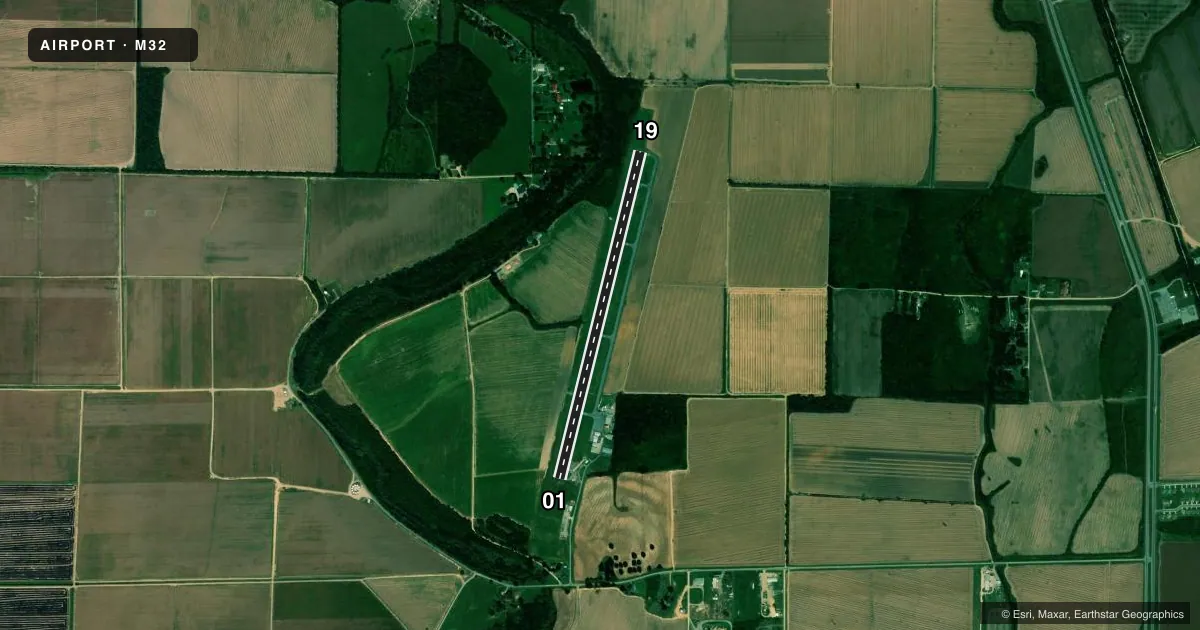
Airport sketch
Runways drawn to scale from FAA survey coordinates, rendered over satellite imagery. Not for navigation.
Approaches & charts
Services on the field
Fuel grades, oxygen, maintenance, ramp storage and lighting — as declared to the FAA by the airport operator.
Fuel & services
- Fuel
- 100LLA
- Oxygen (bottled)
- Not available
- Oxygen (bulk)
- Not available
- Airframe repair
- Not available
- Power plant repair
- Not available
- Other services
- AGRI
Ramp & ground
- Transient storage
- Tie-down
- Customs
- Not available
- Lighting schedule
- SEE RMK
- Beacon schedule
- SS-SR
- Beacon
- White / Green (civil land)(WG)
- Wind indicator
- Lighted
- Segmented circle
- Yes
Fuel & FBOs
Cheapest 100LL and Jet A on the field and nearby. Always confirm with the FBO before taxi.
Airport notes
Surface conditions, obstructions, local procedures, lighting outages and other notes published with each FAA cycle.
General notes
- NUMEROUS AGRICULTURAL OPNS FEB-OCT BELOW 500 FT.
- FOR CD CTC MEMPHIS ARTCC AT 901-368-8453/8449.
Lighting notes
- ACTVT MIRL RWY 01/19, PAPI RWY 01 & 19 - CTAF.
VFR map & nearby airports
VFR sectional. Tap any ICAO chip to open that airport.
Key facts · M32
Answer card- ICAO
- M32
- Name
- LAKE VILLAGE MUNI
- Location
- LAKE VILLAGE, ARKANSAS
- Elevation
- 126.1 ft MSL
- Traffic pattern altitude
- 1,126.1 ft MSL (1,000 AGL)
- Control tower
- Non-towered (use CTAF)
- Total runways
- 1
- Longest runway
- 01/19 · 4,400 ft
- Published ILS approaches
- 0
- Published frequencies
- 1
- Magnetic variation
- 1°
- Current flight rules
- VFR
- Current wind
- 250° at 5 kt
- Favored runway now
- RWY 19
Lake Village Muni sits in Lake Village, Arkansas. Field elevation is 126.1 ft MSL. The airport has one runway, 01/19, which is 4,400 ft long with an asphalt surface. There is no control tower. CTAF is 122.9.
No ILS approaches are published here. The pattern altitude is not published, so use the standard 1,000 ft AGL for light piston traffic unless the current FAA Chart Supplement says otherwise. The runway lights on 01/19 are medium intensity. The PAPI on runways 01 and 19 is controlled from CTAF. That is useful after dark because you will need to key the radio for lighting.
No on-field FBOs are listed in the facts, so verify fuel and services with the airport operator or the field on CTAF before you go. Clearance delivery is handled through Memphis ARTCC using the published phone numbers in the Chart Supplement. One operational item to keep in mind is the agricultural traffic. Numerous ag operations occur from February through October below 500 ft. Expect low-level activity in the area. This is a small non-towered field with simple runway geometry. You still want to brief the CTAF, lighting and local traffic picture before arrival.