METAR & TAF 14M
14M does not publish a METAR.
Showing the nearest reporting station: KGLH (GREENVILLE MID-DELTA) · 19.7 NM away. Conditions at 14M may differ.
METAR · KGLH
Observed 12:53Z
KGLH 271253Z 25006KT 10SM CLR 29/23 A2997 RMK AO2 SLP153 T02890228
- Wind
- 250° @ 6 kt
- Visibility
- 10 SM
- Temp / Dew
- 29°C / 23°C
- Altimeter
- 29.97 inHg
- Clouds
- CLR
- Density alt
- 1,759 ft
- Ceiling
- Unlimited
- Rules
- VFR
Airport info & contacts
Manager on record, flight service, ARTCC, attendance schedule and pattern altitude — published by the FAA and refreshed every 28 days.
Location
- From city
- 2 NM NE
- VFR sectional
- MEMPHIS
- ARTCC
- ZME · MEMPHIS
- NOTAM facility
- GWO (NOTAM-D)
Airport manager
- Name
- MICHAEL MAYBELL
- Phone
- 662-827-2241
- Address
- PO BOX 395, HOLLANDALE MS 38748
Flight service · Hours
- FSS GWO
- GREENWOOD1-800-WX-BRIEF
- Attendance
- Unattended
Frequencies
Tap any row to copy the frequency to your clipboard.
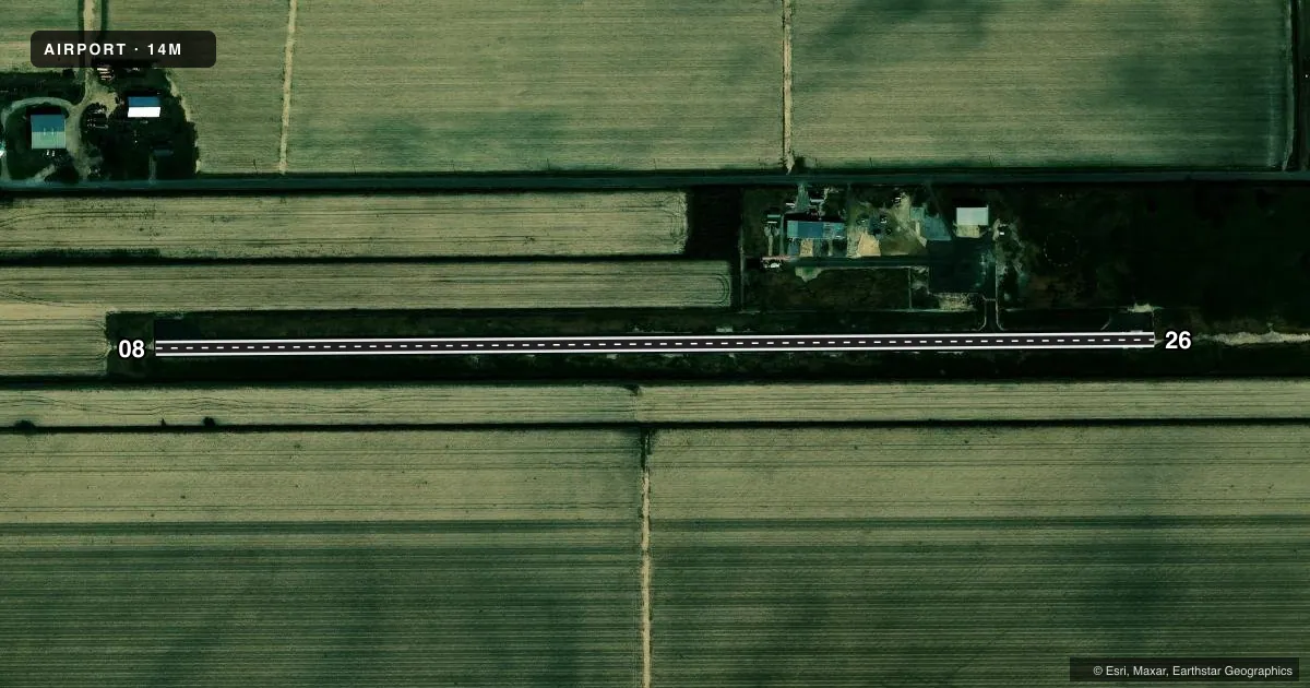
Runways & pattern
Full pagePattern entry · RWY 26
LEFT TRAFFICRunway end performance
| End | TORA | TODA | ASDA | LDA | VGSI | Approach lights | Obstruction |
|---|---|---|---|---|---|---|---|
| 08 | — | — | — | — | PAPI 2-box left(3°) | — | — |
| 26 | — | — | — | — | PAPI 2-box left(3°) | — | — |
Declared distances in feet. TORA = takeoff run available, TODA = takeoff distance, ASDA = accelerate-stop, LDA = landing distance.
Airport sketch
Runways drawn to scale from FAA survey coordinates, rendered over satellite imagery. Not for navigation.
Approaches & charts
Services on the field
Fuel grades, oxygen, maintenance, ramp storage and lighting — as declared to the FAA by the airport operator.
Fuel & services
- Fuel
- Not available
- Oxygen (bottled)
- Not available
- Oxygen (bulk)
- Not available
- Airframe repair
- Not available
- Power plant repair
- Not available
- Other services
- AGRI
Ramp & ground
- Transient storage
- Tie-down
- Landing fee
- No fee published
- Customs
- Not available
- Lighting schedule
- SEE RMK
- Beacon schedule
- SS-SR
- Beacon
- White / Green (civil land)(WG)
- Wind indicator
- Lighted
- Segmented circle
- Yes
Fuel & FBOs
Cheapest 100LL and Jet A on the field and nearby. Always confirm with the FBO before taxi.
Airport notes
Surface conditions, obstructions, local procedures, lighting outages and other notes published with each FAA cycle.
General notes
- FOR CD CTC MEMPHIS ARTCC AT 901-368-8453/8449.
Lighting notes
- OTS INDEFLY.
- OPS 1700-2200; AFT 2200 ACTVT MIRL RWY 08/26 - CTAF.
Approach & departure obstructions
- 08PAPI OTS INDEFLY.
- 26PAPI OTS INDEFLY.
Other notes
- PILOTS MUST PRVD THEIR OWN TIEDOWN ROPES.
- MANAGERMAYOR OF HOLLANDALE - HONORABLE MICHAEL MAYBELL.
- MANAGERPOLICE STATION FOR AFT HRS 601-827-2212.
VFR map & nearby airports
VFR sectional. Tap any ICAO chip to open that airport.
Key facts · 14M
Answer card- ICAO
- 14M
- Name
- HOLLANDALE MUNI
- Location
- HOLLANDALE, MISSISSIPPI
- Elevation
- 113.5 ft MSL
- Traffic pattern altitude
- 1,113.5 ft MSL (1,000 AGL)
- Control tower
- Non-towered (use CTAF)
- Total runways
- 1
- Longest runway
- 08/26 · 3,000 ft
- Published ILS approaches
- 0
- Published frequencies
- 1
- Magnetic variation
- 3°
- Current flight rules
- VFR
- Current wind
- 250° at 6 kt
- Favored runway now
- RWY 26
Hollandale Muni sits in Hollandale, Mississippi. The field elevation is 113.5 ft MSL. It has one runway. Runway 08/26 is 3,000 ft of asphalt. There is no control tower. CTAF is 122.9.
No ILS approaches are published here. The pattern altitude is not published, so use the standard 1,000 ft AGL for light piston traffic unless the current Chart Supplement says otherwise. That puts the traffic pattern at about 1,113.5 ft MSL based on the field elevation, but verify the published pattern before you fly it.
The published remarks matter here. Operations are listed from 1700 to 2200. After 2200, medium intensity runway lights on 08/26 are activated through the common traffic advisory frequency. The PAPI on both runway ends is out of service indefinitely. Pilots also need to bring their own tiedown ropes. There is no on-field FBO listed in the facts, so plan fuel and services with the airport operator or the FBO directly by phone before arrival. For clearance delivery, Memphis ARTCC is the published contact. If you are planning a night arrival or a first visit, check the current Chart Supplement for any changes before you go.